Datei:Sir Bani Yas Island, United Arab Emirates.jpg
Zur Navigation springen
Zur Suche springen

Größe dieser Vorschau: 398 × 599 Pixel. Weitere Auflösungen: 159 × 240 Pixel | 319 × 480 Pixel | 510 × 768 Pixel | 680 × 1.024 Pixel | 1.360 × 2.048 Pixel | 4.016 × 6.048 Pixel
Originaldatei (4.016 × 6.048 Pixel, Dateigröße: 3,34 MB, MIME-Typ: image/jpeg)
![]()
Diese Datei und die Informationen unter dem roten Trennstrich werden aus dem zentralen Medienarchiv Wikimedia Commons eingebunden.
![]()
Beschreibung
| Beschreibung |
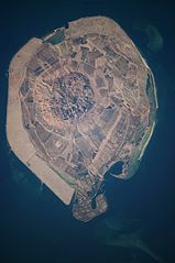
English: This astronaut photograph illustrates the varying character of surfaces on Sir Bani Yas. The central mountains of Jebel Wahid (image centre) mark the location of the Sir Bani Yas salt dome. The dome has breached the surface but exposed salt, primarily gypsum, is eroded, leaving a rugged, insoluble cap made of fragments of the overlaying sedimentary and volcanic rocks. Sand and silt derived from the Jebel Wahid and surrounding gravel-covered areas form beaches along the outer edge of the island. Tan graded areas along the western and north-eastern coast of the island (image bottom and image left) may be re-vegetated with additional plots or developed for other land uses. |
| Datum | |
| Quelle | NASA Earth Observatory |
| Urheber | Image taken by the NASA Expedition 22 crew. |
Image provided by the ISS Crew Earth Observations experiment and Image Science & Analysis Laboratory, Johnson Space Center.
Lizenz
| Diese Datei ist gemeinfrei (public domain), da sie von der NASA erstellt worden ist. Die NASA-Urheberrechtsrichtlinie besagt, dass „NASA-Material nicht durch Urheberrecht geschützt ist, wenn es nicht anders angegeben ist“. (NASA-Urheberrechtsrichtlinie-Seite oder JPL Image Use Policy). | ||
 |
Warnung:
|
| Bildnotizen | Diese Datei ist annotiert: Betrachte diese auf Commons. |
Dateiversionen
Klicke auf einen Zeitpunkt, um diese Version zu laden.
| Version vom | Vorschaubild | Maße | Benutzer | Kommentar | |
|---|---|---|---|---|---|
| aktuell | 11:16, 29. Mär. 2012 | | 4.016 × 6.048 (3,34 MB) | Rotatebot | Bot: Image rotated by 90° |
| 13:51, 15. Mär. 2010 |  | 6.048 × 4.026 (3,35 MB) | Originalwana | {{Information |Description={{en|1=This astronaut photograph illustrates the varying character of surfaces on Sir Bani Yas. The central mountains of Jebel Wahid (image centre) mark the location of the Sir Bani Yas salt dome. The do |
Dateiverwendung
Die folgende Seite verwendet diese Datei:
Globale Dateiverwendung
Die nachfolgenden anderen Wikis verwenden diese Datei:
- Verwendung auf en.wikipedia.org
- Verwendung auf en.wikivoyage.org
- Verwendung auf fa.wikipedia.org
- Verwendung auf fi.wikipedia.org
- Verwendung auf fr.wikipedia.org
- Verwendung auf it.wikipedia.org
- Verwendung auf ja.wikipedia.org
- Verwendung auf pl.wikipedia.org
- Verwendung auf tr.wikipedia.org
- Verwendung auf www.wikidata.org