Datei:City Lights at Night along the France-Italy Border.JPG
Zur Navigation springen
Zur Suche springen

Größe dieser Vorschau: 800 × 529 Pixel. Weitere Auflösungen: 320 × 212 Pixel | 640 × 423 Pixel | 1.024 × 678 Pixel | 1.280 × 847 Pixel | 2.560 × 1.694 Pixel | 4.256 × 2.816 Pixel
Originaldatei (4.256 × 2.816 Pixel, Dateigröße: 8,87 MB, MIME-Typ: image/jpeg)
![]()
Diese Datei und die Informationen unter dem roten Trennstrich werden aus dem zentralen Medienarchiv Wikimedia Commons eingebunden.
![]()
Beschreibung
| Beschreibung |
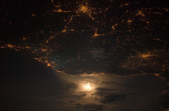
English: The brightly lit metropolitan areas of Torino (Italy), Lyon, and Marseille (both in France) stand out amidst numerous smaller urban areas in this dramatic astronaut photograph. The image captures the nighttime appearance of the France-Italy border. The southwestern end of the Alps Mountains separates the two countries. The island of Corsica is visible in the Ligurian Sea to the south (image top). The full moon reflects brightly on the water surface and also illuminates the tops of low patchy clouds over the border (image centre). This image was taken by an International Space Station (ISS) astronaut at approximately 11:55 p.m. local time, when the ISS was located over the France-Belgium border near Luxembourg. |
| Datum | |
| Quelle | NASA Earth Observatory |
| Urheber | NASA Expedition 23 crew |
| Kameraposition | | Dieses und weitere Bilder auf OpenStreetMap |
|---|
Diese Mediendatei wurde vom Johnson Space Center der US-amerikanischen National Aeronautics and Space Administration (NASA) unter der Datei-ID ISS023-E-29061 kategorisiert. Diese Markierung zeigt nicht den Urheberrechtsstatus des zugehörigen Werks an. Es ist in jedem Falle zusätzlich eine normale Lizenzvorlage erforderlich. Siehe Commons:Lizenzen für weitere Informationen. Sprachen:
|
The astronaut observer was looking towards the south-east at an oblique viewing angle at the time the image was taken; in other words, looking outwards from the ISS, not straight down towards the Earth. Image acquired with a Nikon D3 digital camera, and is provided by the ISS Crew Earth Observations experiment and Image Science & Analysis Laboratory, Johnson Space Center.
Lizenz
| Diese Datei ist gemeinfrei (public domain), da sie von der NASA erstellt worden ist. Die NASA-Urheberrechtsrichtlinie besagt, dass „NASA-Material nicht durch Urheberrecht geschützt ist, wenn es nicht anders angegeben ist“. (NASA-Urheberrechtsrichtlinie-Seite oder JPL Image Use Policy). | ||
 |
Warnung:
|
| Bildnotizen | Diese Datei ist annotiert: Betrachte diese auf Commons. |
Dateiversionen
Klicke auf einen Zeitpunkt, um diese Version zu laden.
| Version vom | Vorschaubild | Maße | Benutzer | Kommentar | |
|---|---|---|---|---|---|
| aktuell | 10:02, 22. Mai 2019 | | 4.256 × 2.816 (8,87 MB) | SteinsplitterBot | Bot: Image rotated by 180° |
| 13:13, 31. Mai 2010 |  | 4.256 × 2.821 (7,84 MB) | Originalwana | {{Information |Description={{en|1=The brightly lit metropolitan areas of Torino (Italy), Lyon, and Marseille (both in France) stand out amidst numerous smaller urban areas in this dramatic astronaut pho |
Dateiverwendung
Keine Seiten verwenden diese Datei.
Globale Dateiverwendung
Die nachfolgenden anderen Wikis verwenden diese Datei:
- Verwendung auf bn.wikipedia.org
- Verwendung auf ca.wikipedia.org
- Verwendung auf en.wikipedia.org
- Verwendung auf it.wikipedia.org
- Verwendung auf nl.wikipedia.org
- Verwendung auf pa.wikipedia.org
- Verwendung auf tt.wikipedia.org
- Verwendung auf uk.wikipedia.org
- Verwendung auf vi.wikipedia.org
- Verwendung auf zh.wikipedia.org