Datei:Carte TGV.svg
Zur Navigation springen
Zur Suche springen

Größe der PNG-Vorschau dieser SVG-Datei: 568 × 600 Pixel. Weitere aus SVG automatisch erzeugte PNG-Grafiken in verschiedenen Auflösungen: 227 × 240 Pixel | 455 × 480 Pixel | 727 × 768 Pixel | 970 × 1.024 Pixel | 1.939 × 2.048 Pixel | 1.000 × 1.056 Pixel
Originaldatei (SVG-Datei, Basisgröße: 1.000 × 1.056 Pixel, Dateigröße: 992 KB)
![]()
Diese Datei und die Informationen unter dem roten Trennstrich werden aus dem zentralen Medienarchiv Wikimedia Commons eingebunden.
![]()
Beschreibung

|
Diese Datei könnte aktualisiert werden, um neue Informationen zu berücksichtigen. Falls die Verwendung einer bestimmten, nicht aktualisierten Version der Datei gewünscht wird, sollte die gewünschte Version separat hochgeladen werden. |
| Beschreibung |
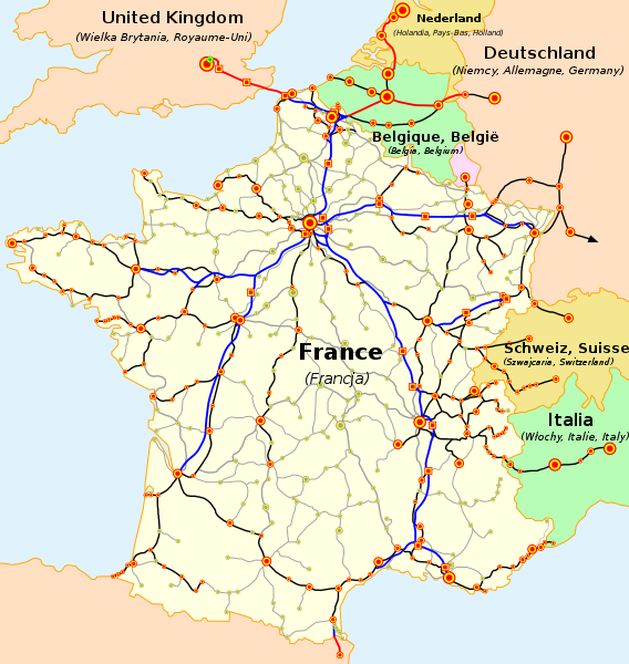
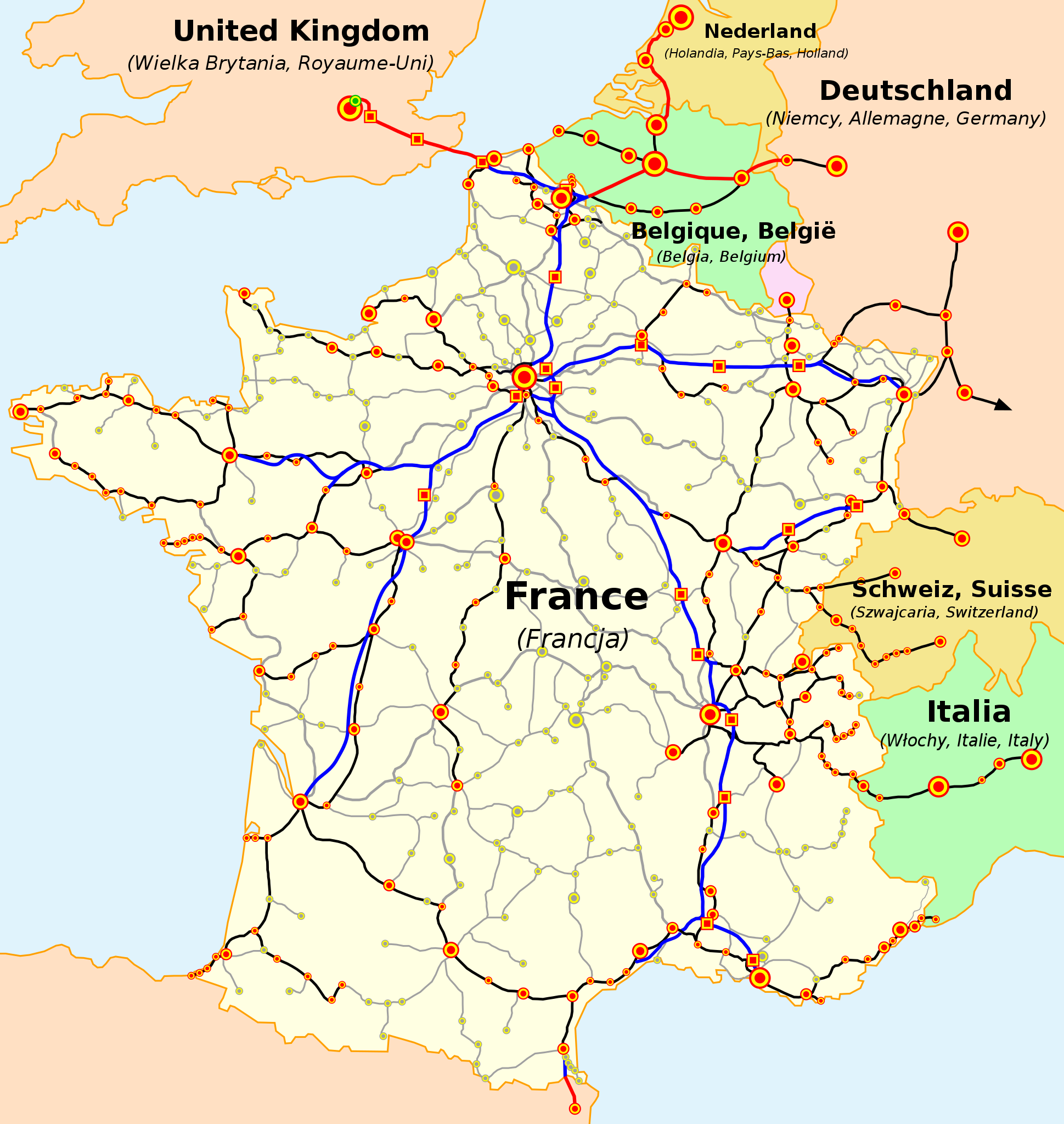
Français : La carte du réseau voyageurs de la SNCF, les TGV internationaux inclus
English: The map of French railways (SNCF) passengers service, including international TGV high-speed trains
Deutsch: Karte der französischen Eisenbahn (SNCF) mit TGV Hochgeschwindigkeitsnetz
Español: Mapa de las líneas de ferrocarril de la SNCF, incluidas las líneas de TGV (alta velocidad)
Čeština: Mapa tratí francouzských železnic (SNCF) s přepravou cestujících včetně mezinárodních spojení TGV
Nederlands: Kaart van de Franse Spoorwegen (SNCF), inclusief internationale TGV hogesnelheidstreinen
Polski: Mapa sieci połączeń pasażerskich kolei francuskich (SNCF), uwzlędniająca międzynarodowe połączenia pociągami TGV
Русский: Карта пассажирского железнодорожного транспорта Франции, включая международные скоростные поезда TGV
Slovenčina: Mapa tratí francúzskych železníc (SNCF) s prepravou cestujúcich a medzinárodných spojení TGV
Català: La xarxa TGV: -en blau i en vermell: línies d'alta velocitat, -en negre: línies clàssiques per on circulen trens TGV, -puntejat: línies en projecte (TGV Est)
(cs) Vysvětlivky
Velikost značek označuje přibližně velikost měst (de) Legende
(es) Leyenda
(en) Legend
(fr) Légende
(nl) Legenda
(pl) Legenda
(sk) Vysvetlivky
|
| Quelle | Map based on SNCF map published on its web site. Travail basé sur la carte du réseau publiée par la SNCF sur son site internet. Praca oparta na mapie opublikowanej na stronie internetowej firmy SNCF. Mapa je vytvorené na základe mapy SNCF publikovanej na tejto web stránke. |
| Urheber |
(en) Own work, author: madcap. |
| Andere Versionen |
Abgeleitete Werke dieser Datei: |
Lizenz

|
Es ist erlaubt, die Datei unter den Bedingungen der GNU-Lizenz für freie Dokumentation, Version 1.2 oder einer späteren Version, veröffentlicht von der Free Software Foundation, zu kopieren, zu verbreiten und/oder zu modifizieren; es gibt keine unveränderlichen Abschnitte, keinen vorderen und keinen hinteren Umschlagtext.
Der vollständige Text der Lizenz ist im Kapitel GNU-Lizenz für freie Dokumentation verfügbar. |
| Diese Datei ist unter der Creative-Commons-Lizenz „Namensnennung – Weitergabe unter gleichen Bedingungen 3.0 nicht portiert“ lizenziert. | ||
| ||
| Diese Lizenzmarkierung wurde auf Grund der GFDL-Lizenzaktualisierung hinzugefügt. |
Dateiversionen
Klicke auf einen Zeitpunkt, um diese Version zu laden.
| Version vom | Vorschaubild | Maße | Benutzer | Kommentar | |
|---|---|---|---|---|---|
| aktuell | 21:25, 5. Jan. 2023 | | 1.000 × 1.056 (992 KB) | Lojwe | Without frame |
| 16:52, 28. Apr. 2021 |  | 1.000 × 1.056 (994 KB) | Bech | Prolongement LGV mediterranée jusqu'à l'est de Montpellier | |
| 11:21, 2. Jul. 2017 |  | 1.000 × 1.056 (790 KB) | Clicgauche | Finalisation LGV Est le 11 décembre 2016 | |
| 11:16, 2. Jul. 2017 |  | 1.000 × 1.056 (791 KB) | Clicgauche | Ouverture LGV Bretagne-Pays de la Loire et LGV Sud Europe Atlantique le 2 juillet 2017 | |
| 17:17, 17. Apr. 2016 |  | 1.000 × 1.056 (1.019 KB) | Jack ma | correction Angoulême and Poitiers: no station directly on the new line between Tours and Bordeaux | |
| 09:22, 1. Jan. 2016 |  | 1.000 × 1.056 (1.021 KB) | Jack ma | correction Angoulême | |
| 02:06, 25. Jan. 2015 |  | 1.000 × 1.056 (1,05 MB) | Muselaar | ajout du barreau manquant entre Manheim et Karlsruhe, emprunté quotidiennement par les TGV Frankfurt-Marseille | |
| 15:49, 15. Okt. 2012 |  | 1.000 × 1.056 (1,04 MB) | Benjism89 | - phase 2 de la LGV Rhin-Rhône (pas encore en construction), + phase LGV Est, LGV SEA et LGV BPL (en construction) | |
| 13:22, 18. Dez. 2011 |  | 1.000 × 1.056 (960 KB) | Pic-Sou | update, fix | |
| 22:13, 3. Aug. 2010 |  | 1.000 × 1.056 (949 KB) | Uwe Dedering | layers to separate text from the rest | |
| 22:01, 3. Aug. 2010 |  | 1.000 × 1.056 (1,12 MB) | Uwe Dedering | better font | |
| 23:33, 5. Jan. 2010 |  | 1.000 × 1.056 (1,12 MB) | Madcap | - (change) colors changed; - (change) font changed to Trebuchet; - (change) Thalys service now on HSL Zuid (Netherland) and LGV 4 (Belgium), classic line not used by the TGV between Antwerp and Schiphol; - (change) The Hague is no longer served by Thalys; | |
| 21:09, 3. Sep. 2009 |  | 1.000 × 1.056 (1,03 MB) | Benjism89 | + liège - aix-la-chapelle, bourg - bellegarde | |
| 10:39, 31. Aug. 2009 |  | 1.000 × 1.056 (1,03 MB) | Benjism89 | + le havre - strasbourg, - lausanne - berne - zurich | |
| 16:46, 3. Jul. 2009 |  | 1.000 × 1.056 (1,03 MB) | Benjism89 | ajout cherbourg - dijon, paris - les sables d'olonne | |
| 00:13, 25. Mär. 2008 |  | 1.000 × 1.056 (990 KB) | Madcap | Maybe this time it will work... | |
| 02:46, 24. Mär. 2008 |  | 1.000 × 1.056 (990 KB) | Madcap | Reverted to version as of 00:40, 24 March 2008 | |
| 02:45, 24. Mär. 2008 |  | 1.000 × 1.056 (990 KB) | Madcap | Old version mistakenly uploaded | |
| 02:40, 24. Mär. 2008 |  | 1.000 × 1.056 (990 KB) | Madcap | (pl) Liczne poprawki mapki: * Zmiana kolorow * Linia High Speed 1 (Wielka Wrytania): ** drugi odcinek linii otwarty, ** dodano dwa dworce: Stratford International (jescze nie obslugiwany, zaznaczony jako "w budowie") oraz Ebbsfleet International (obecnie | |
| 09:48, 19. Jun. 2007 |  | 1.000 × 1.056 (977 KB) | Andrew pmk~commonswiki | update map to show that LGV Est is now open; correct spelling error | |
| 01:11, 10. Jun. 2007 |  | 1.000 × 1.056 (1.004 KB) | PemFR | {{French TGV network map |Description= |Source= |Date= |Author= |Permission= |other_versions= }} | |
| 00:37, 10. Jun. 2007 |  | 1.000 × 1.056 (1.004 KB) | PemFR | {{Information |Description=French TGV network map |Source= |Date= |Author= |Permission= |other_versions= }} | |
| 14:57, 17. Sep. 2006 |  | 1.000 × 1.056 (1.004 KB) | Steff | == Summary == (en) The map of French railways (SNCF) passengers service, including internationnal TGV high-speed trains.<br> (fr) La carte du réseau voyageurs de la SNCF, les TGV internationaux inclus.<br> (pl) Mapa sieci połączeń pasażerskich kolei | |
| 07:53, 24. Mär. 2006 |  | 1.000 × 1.056 (1,01 MB) | Madcap | (en) The map of French railways (SNCF) passengers service, including internationnal TGV high-speed trains.<br> (fr) La carte du réseau voyageurs de la SNCF, les TGV internationaux inclus.<br> (pl) Mapa sieci połączeń pasażerskich kolei francuskich (S |
Dateiverwendung
Die folgenden 9 Seiten verwenden diese Datei:
Globale Dateiverwendung
Die nachfolgenden anderen Wikis verwenden diese Datei:
- Verwendung auf ar.wikipedia.org
- Verwendung auf ca.wikipedia.org
- Verwendung auf cs.wikipedia.org
- Verwendung auf da.wikipedia.org
- Verwendung auf en.wikipedia.org
- Verwendung auf es.wikipedia.org
- Verwendung auf es.wikivoyage.org
- Verwendung auf fi.wikipedia.org
- Verwendung auf fr.wikipedia.org
- Verwendung auf fr.wikivoyage.org
- Verwendung auf he.wikipedia.org
- Verwendung auf ja.wikipedia.org
- Verwendung auf ko.wikipedia.org
- Verwendung auf lb.wikipedia.org
- Verwendung auf mk.wikipedia.org
- Verwendung auf ms.wikipedia.org
- Verwendung auf nl.wikipedia.org
- Verwendung auf oc.wikipedia.org
- Verwendung auf pl.wikipedia.org
- Verwendung auf pnb.wikipedia.org
- Verwendung auf ro.wikipedia.org
- Verwendung auf sh.wikipedia.org
- Verwendung auf simple.wikipedia.org
- Verwendung auf sk.wikipedia.org
- Verwendung auf th.wikipedia.org
- Verwendung auf tr.wikipedia.org
- Verwendung auf uk.wikipedia.org
- Verwendung auf ur.wikipedia.org
- Verwendung auf www.wikidata.org
- Verwendung auf zh.wikipedia.org