Datei:New-Map-Francophone World.PNG
Zur Navigation springen
Zur Suche springen

Größe dieser Vorschau: 800 × 441 Pixel. Weitere Auflösungen: 320 × 176 Pixel | 640 × 353 Pixel | 1.024 × 564 Pixel | 1.280 × 705 Pixel | 2.664 × 1.468 Pixel
Originaldatei (2.664 × 1.468 Pixel, Dateigröße: 93 KB, MIME-Typ: image/png)
![]()
Diese Datei und die Informationen unter dem roten Trennstrich werden aus dem zentralen Medienarchiv Wikimedia Commons eingebunden.
![]()
Beschreibung
| Beschreibung |
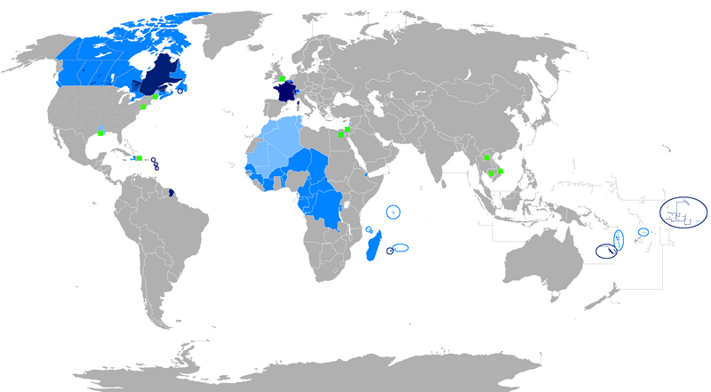
English: The French language and French creoles in the world
Regions where French or a French creole is the main language
Regions where it is an official language
Regions where it is a second language
Regions where it is a minority language
The following things have been changed from the old "Map-Francophone World.PNG":
To be modified :
Français : La langue française dans le monde
Langue maternelle
Langue officielle
Deuxième langue
Minorités francophones
Les choses suivantes ont été modifiées de l'ancien "Map-Frncophone World.PNG":
Proposition de modification : L'usage de la langue française est divers dans les pays d'Afrique subsaharienne. Par exemple, le français n'est pas la langue utilisée par défaut dans les rues sénégalaises. Tout au contraire, prétendre que le français n'est pas la langue maternelle des Gabonais reviendrait à dire que le français n'était rien de plus qu'une langue officielle dans la Bretagne des années cinquante. Ne connaissant pas la situation des autres pays, je laisse le soin à toute personne motivée de corriger cette erreur.
Català: La llengua francesa al món
Llengua materna
Llengua oficial
Segona Llengua
Minories francòfones |
| Datum | |
| Quelle | Eigenes Werk |
| Urheber | aaker |

|
File:New-Map-Francophone World.svg ist eine vektorisierte Version dieses Bildes. Diese sollte an Stelle des Rasterbildes verwendet werden, sofern sie nicht schlechter ist.
File:New-Map-Francophone World.PNG → File:New-Map-Francophone World.svg
Für weitere Informationen siehe Help:SVG. |
 |
Lizenz
| Ich, der Urheberrechtsinhaber dieses Werkes, veröffentliche es als gemeinfrei. Dies gilt weltweit. In manchen Staaten könnte dies rechtlich nicht möglich sein. Sofern dies der Fall ist: Ich gewähre jedem das bedingungslose Recht, dieses Werk für jedweden Zweck zu nutzen, es sei denn, Bedingungen sind gesetzlich erforderlich. |
Dateiversionen
Klicke auf einen Zeitpunkt, um diese Version zu laden.
| Version vom | Vorschaubild | Maße | Benutzer | Kommentar | |
|---|---|---|---|---|---|
| aktuell | 02:15, 30. Jul. 2023 | | 2.664 × 1.468 (93 KB) | Riad Salih | Western Sahara is an old Spanish colony, and French is not commonly used there. |
| 02:10, 30. Jul. 2023 |  | 2.664 × 1.468 (93 KB) | Riad Salih | Since July 2023, French is no longer an official language in Mali, but a language of work. | |
| 08:49, 30. Apr. 2023 |  | 2.664 × 1.468 (205 KB) | Moalli | Remove green square in middle of Mediterranean, no country located there | |
| 00:50, 16. Mär. 2023 |  | 2.664 × 1.468 (105 KB) | Kwamikagami | update some per WP-en article, though this map not used much anymore | |
| 12:21, 9. Aug. 2019 |  | 2.664 × 1.468 (120 KB) | Benderban01 | Reverted to version as of 15:28, 17 July 2018 (UTC) | |
| 11:07, 6. Aug. 2019 |  | 2.664 × 1.468 (119 KB) | Benderban01 | Removed the small thing on ontario. | |
| 11:01, 6. Aug. 2019 |  | 2.664 × 1.468 (119 KB) | Benderban01 | Removed 8 provinces where french is not the official language, there 3 territorries which will spoke minority. | |
| 17:28, 17. Jul. 2018 |  | 2.664 × 1.468 (120 KB) | Maphobbyist | Reverted to version as of 18:46, 4 January 2018 (UTC) | |
| 11:53, 27. Jun. 2018 |  | 2.664 × 1.468 (100 KB) | Motiss | ||
| 11:50, 27. Jun. 2018 |  | 2.664 × 1.468 (120 KB) | Motiss | Reverted to version as of 18:46, 4 January 2018 (UTC) | |
| 11:48, 27. Jun. 2018 |  | 2.664 × 1.468 (14,94 MB) | Motiss | ||
| 20:46, 4. Jan. 2018 |  | 2.664 × 1.468 (120 KB) | Maphobbyist | Sticking to sources. French is not the majority mother language in New Caledonia, French Polynesia and some Western African cities. | |
| 11:44, 3. Jan. 2018 |  | 2.664 × 1.468 (124 KB) | Julienbch | Back to previous version. French is clearly the main language in New Caledonia, in F. Polynesia and in some cities of western and central Africa. | |
| 13:41, 25. Dez. 2017 |  | 2.664 × 1.468 (120 KB) | Maphobbyist | Update | |
| 14:31, 11. Jun. 2017 |  | 2.664 × 1.468 (124 KB) | Zorion | Canada: Carte plus réaliste pour l'Ontario, minorités de langues maternelles françaises dans le reste du Canada. Changement de couleur pour le Luxembourg car 6% de langue maternelle et 90% de langue seconde française | |
| 21:10, 11. Mär. 2017 |  | 2.664 × 1.468 (122 KB) | Fobos92 | Canadá francesa | |
| 02:01, 10. Okt. 2016 |  | 2.664 × 1.468 (100 KB) | फ़िलप्रो | remove India | |
| 14:02, 30. Aug. 2016 |  | 2.664 × 1.468 (119 KB) | Zorion | De Hearst jusqu'à la frontière du Québec, c'est une zone majoritairement francophone, ainsi que les Comtés unis de Prescott et Russell | |
| 03:52, 14. Aug. 2016 |  | 2.664 × 1.468 (94 KB) | TitaniumCarbide | remove arbitrary blob of francophone ontario - while there is a high density of francophone communities in this corridor, only census division in Ontario with a majority of mother-tongue Francophones is Prescott and Russell (area East of Ottawa) | |
| 16:21, 23. Jul. 2016 |  | 2.664 × 1.468 (102 KB) | Jejesga06 | Correction d'une erreur qui m'avait échappée. La Sarre n'a pas le français comme langue officiel mais comme seconde langue avec une importance de la langue et l'État de Sarre souhaite devenir bilingue. | |
| 16:06, 23. Jul. 2016 |  | 2.664 × 1.468 (102 KB) | Jejesga06 | Bonjour, voici mes apports: - Modification de "2ème langue" pour la Syrie en langue minoritaire. - Seconde langue du français dans l'État de la Sarre (Allemagne) (qui possède beaucoup de francophones et qui souhaite devenir bilingue). - Langue mate... | |
| 04:02, 11. Mai 2016 |  | 2.664 × 1.468 (119 KB) | Zorion | From Hearst, Ontario to Abitibi, it's a francophone area | |
| 17:38, 12. Mär. 2016 |  | 2.664 × 1.468 (197 KB) | Julienbch | FR / Correction de quelques erreurs par rapport à ma précédente version et cercle plus grand dans les Antilles et à Saint-Pierre et Miquelon pour une meilleure lisibilité. EN / Correction of mistakes in my previous version + bigger circles for a b... | |
| 17:32, 11. Mär. 2016 |  | 2.664 × 1.468 (197 KB) | Julienbch | Color change : Northern Belgium, eastern Switzerland, Reunion island, New Caledonia (French is the 1st language of the majority of the population) and French Polynesia (where french is used as 1st language at home by 75% of the population). New territo... | |
| 00:05, 18. Feb. 2016 |  | 2.664 × 1.468 (118 KB) | Fobos92 | . | |
| 13:05, 12. Feb. 2016 |  | 2.664 × 1.468 (118 KB) | Fobos92 | . | |
| 12:47, 2. Okt. 2015 |  | 1.357 × 631 (38 KB) | Zorion | Dans la région Nord-du-Québec (44% francophone en 2006), la Jamesie est francophone. Dans le Kativik, Rivière-Koksoak et Baie-d'Hudson les mines emploient des milliers de travailleurs et les 14 villages nordiques parlent inuit. Eeyou Istchee Baie-Ja... | |
| 05:38, 29. Sep. 2015 |  | 1.357 × 631 (34 KB) | Nicolas Perrault III | Northern Quebec is indigenous. Most indigenous people in Northern Quebec speak English as a second language. | |
| 21:15, 30. Apr. 2015 |  | 1.357 × 631 (38 KB) | Zorion | From Hearst, Ontario to Abitibi, it's a francophone area + Anticostie added + Remove a part of New-Brunswick. | |
| 13:37, 21. Mär. 2015 |  | 1.357 × 631 (38 KB) | Lubiesque | Vietnam, Laos, Cambodia eliminated | |
| 03:51, 14. Sep. 2014 |  | 1.357 × 631 (38 KB) | Leftcry | Fix borders | |
| 03:28, 16. Mär. 2013 |  | 1.357 × 631 (54 KB) | Maphobbyist | In New Caledonia, French is the sole official language, but it is the mother language of a minority. | |
| 18:42, 15. Mär. 2013 |  | 1.357 × 631 (55 KB) | Maphobbyist | In Syria, French is a second language and in the cultural, commercial and administrative fields. In Aosta, French is an official language spoken by the majority. | |
| 15:33, 13. Aug. 2011 |  | 1.357 × 631 (55 KB) | A.h. king | . | |
| 00:37, 27. Mär. 2009 |  | 1.357 × 631 (28 KB) | Bestofmed | Fixed legend color for some countries where French is not official neither is an administrative language. | |
| 14:22, 19. Jan. 2009 |  | 1.357 × 631 (42 KB) | Bosonic dressing | {{Information |Description=map; updated to reflect that French is an official language in Canada Belgium, and Switzerland (at federal levels) |Source= |Date= |Author= |Permission= |other_versions= }} | |
| 14:18, 19. Jan. 2009 |  | 1.357 × 631 (42 KB) | Bosonic dressing | {{Information |Description=map; updated to reflect that French is an official language in Canada (federally) |Source= |Date= |Author= |Permission= |other_versions= }} | |
| 21:21, 23. Okt. 2008 |  | 1.357 × 631 (48 KB) | Aaker | Reverted to version as of 20:58, 18 October 2007 | |
| 16:20, 18. Sep. 2008 |  | 1.357 × 631 (31 KB) | Wikinv~commonswiki | Updated per the discussion page. | |
| 22:58, 18. Okt. 2007 |  | 1.357 × 631 (48 KB) | Aaker | ||
| 15:52, 15. Aug. 2007 |  | 1.357 × 631 (48 KB) | Aaker | {{Information |Description=A new one |Source=own work |Date=15 August, 2007 |Author=aaker |Permission= |other_versions= }} |
Dateiverwendung
Die folgenden 3 Seiten verwenden diese Datei:
Globale Dateiverwendung
Die nachfolgenden anderen Wikis verwenden diese Datei:
- Verwendung auf en.wikipedia.org
- Category:Wikipedians in Luxembourg
- Category:Wikipedians in Switzerland
- Category:WikiProject Luxembourg participants
- Category:WikiProject Switzerland participants
- Category:Swiss Wikipedians
- Talk:English language/Archive 18
- Talk:French language/Archive 3
- Category:Wikipedians interested in Luxembourg
- Category:Wikipedians interested in Switzerland
- Category:Luxembourg Wikipedians
- Template:Portal/doc/all
- Wikipedia:Reference desk/Archives/Humanities/2013 October 5
- User:Matt Fitzpatrick/portal images
- Wikipedia:Userboxes/Location/Luxembourg
- Wikipedia:Userboxes/Location/Switzerland
- Template:User Luxembourg/cat
- Template:User Switzerland/cat
- Template:User Luxembourg/boxes
- Template:User Switzerland/boxes
- Verwendung auf es.wikipedia.org
- Verwendung auf fi.wikipedia.org
- Verwendung auf fr.wikipedia.org
- Discussion:Francophonie
- Discussion utilisateur:Le sotré
- Liste des pays ayant le français pour langue officielle
- Wikipédia:Le Bistro/24 février 2008
- Utilisateur:Brochon99/Bac à sable 5/Documentation
- Wikipédia:Le Bistro/18 décembre 2009
- Utilisateur:Kimdime/stats
- Utilisateur:Ygdrasil/http://Liste langue par nbr locuteur
- Utilisateur:Televido/Récolte
- Wikipédia:Le Bistro/25 juillet 2017
- Wikipédia:Le Bistro/30 juillet 2017
- Verwendung auf fr.wikinews.org
- Verwendung auf fr.wiktionary.org
- Verwendung auf jv.wikipedia.org
- Verwendung auf km.wikipedia.org
- Verwendung auf nl.wikipedia.org
- Verwendung auf so.wikipedia.org
- Verwendung auf tum.wikipedia.org