Datei:Courtyard and interior structures at Bent's Old Fort, outside La Junta in Otero County, Colorado LCCN2015632789.tif
Zur Navigation springen
Zur Suche springen

Größe der JPG-Vorschau dieser TIF-Datei: 800 × 534 Pixel. Weitere Auflösungen: 320 × 214 Pixel | 640 × 427 Pixel | 1.024 × 683 Pixel | 1.280 × 854 Pixel | 2.560 × 1.709 Pixel | 7.360 × 4.912 Pixel
Originaldatei (7.360 × 4.912 Pixel, Dateigröße: 206,9 MB, MIME-Typ: image/tiff)
![]()
Diese Datei und die Informationen unter dem roten Trennstrich werden aus dem zentralen Medienarchiv Wikimedia Commons eingebunden.
![]()
Beschreibung
| Beschreibung |
English: Title: Courtyard and interior structures at Bent's Old Fort, outside La Junta in Otero County, Colorado
Physical description: 1 photograph : digital, tiff file, color. Notes: Purchase; Carol M. Highsmith Photography, Inc.; 2015; (DLC/PP-2015:068).; Forms part of: Gates Frontiers Fund Colorado Collection within the Carol M. Highsmith Archive.; Occasionally referred to as Fort William, the fort is a 1976 reconstruction of an 1833 fort built by William and Charles Bent, along with Ceran St. Vrain, as a post from which to trade with trappers and Southern Cheyenne and Arapaho Plains Indians for buffalo robes.; Title, date and keywords based on information provided by the photographer.; Credit line: Gates Frontiers Fund Colorado Collection within the Carol M. Highsmith Archive, Library of Congress, Prints and Photographs Division. |
||||||||||||||||||||||||||
| Datum | Aufgenommen am 25. Mai 2015, 15:42 (gemäß Exif-Daten) | ||||||||||||||||||||||||||
| Quelle |
Library of Congress
|
||||||||||||||||||||||||||
| Urheber |
|
||||||||||||||||||||||||||
| Genehmigung (Weiternutzung dieser Datei) |
No known restrictions on publication.
|
||||||||||||||||||||||||||


| Kameraposition | | Dieses und weitere Bilder auf OpenStreetMap |
|---|
Lizenz
| Dieses Werk stammt aus der Carol M. Highsmith Archive-Sammlung der Library of Congress. Laut der Bibliothek gibt es keine bekannten Copyright-Einschränkungen in der Verwendung dieses Werkes. Carol M. Highsmith has stipulated that her photographs are in the public domain. Photographs of sculpture or other works of art may be restricted by the copyright of the artist; see Commons:FOP US#Artworks and sculptures for more information. |
 |
Dateiversionen
Klicke auf einen Zeitpunkt, um diese Version zu laden.
| Version vom | Vorschaubild | Maße | Benutzer | Kommentar | |
|---|---|---|---|---|---|
| aktuell | 09:24, 12. Sep. 2016 |  | 7.360 × 4.912 (206,9 MB) | Fæ | LOC 2015632789, Carol M. Highsmith collection. P940.14330 TIFF (206.9mb) |
| 09:23, 12. Sep. 2016 | 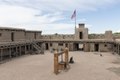 | 7.360 × 4.912 (206,9 MB) | Fæ | LOC 2015632789, Carol M. Highsmith collection. P940.14330 TIFF (206.9mb) |
Dateiverwendung
Die folgende Seite verwendet diese Datei:
Globale Dateiverwendung
Die nachfolgenden anderen Wikis verwenden diese Datei:
- Verwendung auf en.wikipedia.org
- Verwendung auf tr.wikipedia.org