Datei:Link light rail geographic map.svg
Zur Navigation springen
Zur Suche springen

Größe der PNG-Vorschau dieser SVG-Datei: 550 × 600 Pixel. Weitere aus SVG automatisch erzeugte PNG-Grafiken in verschiedenen Auflösungen: 220 × 240 Pixel | 440 × 480 Pixel | 705 × 768 Pixel | 939 × 1.024 Pixel | 1.879 × 2.048 Pixel | 1.600 × 1.744 Pixel
Originaldatei (SVG-Datei, Basisgröße: 1.600 × 1.744 Pixel, Dateigröße: 597 KB)
![]()
Diese Datei und die Informationen unter dem roten Trennstrich werden aus dem zentralen Medienarchiv Wikimedia Commons eingebunden.
![]()
Beschreibung

|
Es wird erwartet, dass dieses Bild stets auf dem neuesten Stand ist. Aktualisiere es ruhig, falls nötig.
|
| Beschreibung |
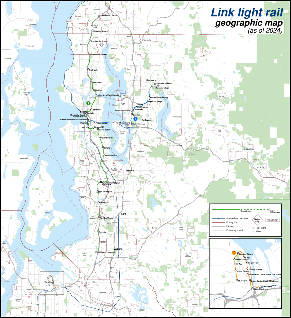
English: A geographically-accurate map of lines of the Link light rail, including parts under construction (dashed in map), overlayed on a basemap containing the Silver Line and commuter rail lines, municipalities, roads, water areas, area landmarks, and green spaces. Shapefiles from the United States Census Bureau, the U.S. Geological Survey (USGS) Gap Analysis Project (GAP), Sound Transit, and OpenStreetMap (© OpenStreetMap contributors), converted with Mapshaper and Inkscape (Mercator projection). |
| Datum | |
| Quelle | Eigenes Werk |
| Urheber | Twotwofourtysix |
Lizenz
Ich, der Urheber dieses Werkes, veröffentliche es unter der folgenden Lizenz:
Diese Datei ist lizenziert unter der Creative-Commons-Lizenz „Namensnennung – Weitergabe unter gleichen Bedingungen 4.0 international“.
- Dieses Werk darf von dir
- verbreitet werden – vervielfältigt, verbreitet und öffentlich zugänglich gemacht werden
- neu zusammengestellt werden – abgewandelt und bearbeitet werden
- Zu den folgenden Bedingungen:
- Namensnennung – Du musst angemessene Urheber- und Rechteangaben machen, einen Link zur Lizenz beifügen und angeben, ob Änderungen vorgenommen wurden. Diese Angaben dürfen in jeder angemessenen Art und Weise gemacht werden, allerdings nicht so, dass der Eindruck entsteht, der Lizenzgeber unterstütze gerade dich oder deine Nutzung besonders.
- Weitergabe unter gleichen Bedingungen – Wenn du das Material wiedermischst, transformierst oder darauf aufbaust, musst du deine Beiträge unter der gleichen oder einer kompatiblen Lizenz wie das Original verbreiten.
Dateiversionen
Klicke auf einen Zeitpunkt, um diese Version zu laden.
| Version vom | Vorschaubild | Maße | Benutzer | Kommentar | |
|---|---|---|---|---|---|
| aktuell | 04:49, 5. Mai 2024 | | 1.600 × 1.744 (597 KB) | Twotwofourtysix | Update with opening of line section |
| 09:58, 4. Mai 2024 |  | 1.600 × 1.744 (635 KB) | OrdinaryScarlett | Update date | |
| 09:01, 4. Mai 2024 |  | 1.600 × 1.744 (673 KB) | SounderBruce | Remove CDP "boundaries" that change with every census; cleanup label placement on 2 Line | |
| 04:41, 1. Mai 2024 |  | 1.600 × 1.744 (651 KB) | OrdinaryScarlett | Update 2 Line and Lynnwood and Federal Way Link Extension station names | |
| 22:05, 19. Jan. 2024 |  | 1.600 × 1.744 (690 KB) | SounderBruce | Removing most labels for CDPs, which are arbitrarily assigned by the Census Bureau and change frequently; boundaries should also be deleted at some point | |
| 16:18, 19. Jan. 2024 |  | 1.600 × 1.744 (650 KB) | Twotwofourtysix | Adds legend & title, adjusts colours | |
| 17:58, 18. Jan. 2024 |  | 1.600 × 1.744 (1,76 MB) | Twotwofourtysix | Uploaded own work with UploadWizard |
Dateiverwendung
Die folgende Seite verwendet diese Datei:
Globale Dateiverwendung
Die nachfolgenden anderen Wikis verwenden diese Datei:
- Verwendung auf ca.wikipedia.org
- Verwendung auf cs.wikipedia.org
- Verwendung auf de.wikivoyage.org
- Verwendung auf en.wikipedia.org
- Verwendung auf es.wikipedia.org
- Verwendung auf fa.wikipedia.org
- Verwendung auf fr.wikipedia.org
- Verwendung auf it.wikipedia.org
- Verwendung auf mr.wikipedia.org
- Verwendung auf uk.wikipedia.org
- Verwendung auf www.wikidata.org
- Verwendung auf zh.wikipedia.org