Datei:Morro Strand State Beach (1).jpg

Originaldatei (2.038 × 1.358 Pixel, Dateigröße: 1,86 MB, MIME-Typ: image/jpeg)
![]()
Diese Datei und die Informationen unter dem roten Trennstrich werden aus dem zentralen Medienarchiv Wikimedia Commons eingebunden.
![]()
.jpg?uselang=de)
Beschreibung
| Beschreibung |
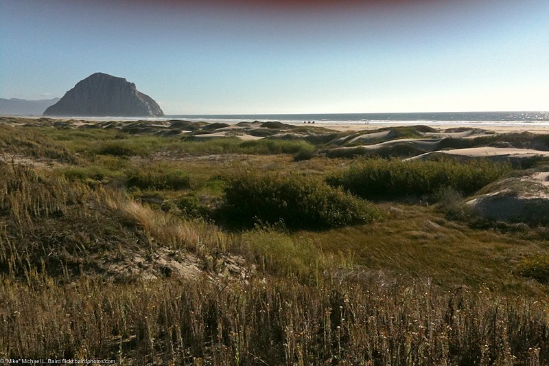
Morro Strand State Beach — viewed from the Back Dunes with Morro Rock, located on Estero Bay in San Luis Obispo County, California.
History
Terrestrial Plant Communities
While not vegetated by plants, the Strand is an important community that provides habitat and food for many species. The Strand is the area of the beach between the supralittoral zone and the foredunes. It is characterized by salt spray, fog water inundation, high winds, blowing sand, and accumulations of uprooted marine algae, driftwood and other debris. Common wrack-line seaweeds on the Strand include: Macrocystis spp. (giant kelps), Nerocystis spp. (bull kelps), Fucus spp. (rock kelps), Egregia spp. (feather boas), and Uva spp. (sea lettuce). The mounds of washed-up seaweed provide food and habitat for many invertebrate species and food for vertebrates such as birds. Above the high tide line the sand begins to accumulate at the foredunes.
According to Orme (1990), coastal dune creation and mobility are favored by abundant beach sand and onshore winds above the threshold velocity for sand entrainment and the primary stabilizing factor is the effectiveness of sand-binding vegetation. MSSB is part of the Morro Dune Complex which stretches from Montana de Oro State Park (MDO) to the south and north to Cayucos and Villa Creek. MSSB is, however, significantly less diverse than the dune communities found at MDO, presumably from direct human impacts and the spread of Ammophila arenaria. Native species not found at MSSB but present at MDO include: Leymus mollis (native dunegrass), Eriastrum densiflora (woolly gilia), Dithyrea maritima (beach spectacle pod), Malacothrix incana (dune-delion) and Dudleya caespitosa (dudleya). Many of these native species are being re-introduced as part of our restoration efforts.
The fore or pioneer dunes are those dunes located nearest to the shoreline. They are characterized by a high rate of sand movement which exceeds the rate of colonization by vegetation. This region of the sand dunes is subject to extremely harsh environmental factors which greatly reduces plant life and diversity as well as provides uniquely adapted assemblages of plants. Such conditions include: desiccation from wind and salt spray, salt and sand abrasion, high reflectivity and surface temperatures, constant fog, fluctuating tides, high salt content in the soils, low soil fertility and water holding capacity, and constant burial, excavation, and re-burial of root systems. The plants that grow on the foredunes are often called dune stabilizers and are very tolerant of the above mentioned environmental pressures. Foredune plant species are often prostrate or creeping along the soil surface, have small succulent leaves with pubescence, are light in color, and have a small surface to volume ratio. They also typically have a large tap root, a complex shallow or surface root system and generally root at the nodes.
Stabilized or back dunes occur inland of the pioneer dunes at MSSB where there is enough vegetation present to reduce or stop the rate of air movement along the sand surface. Stabilized dunes are considered to be older dune communities and are classified by their increase in plant species diversity and composition. These species are, however, less tolerant of the harsh environmental variables that affect species in the pioneer dunes and are therefore restricted to the more sheltered regions of the dune ecosystem. There are many different plant communities that occur on stabilized dunes. Those present at MSSB include: coastal dune scrub, coastal dune swale, Riparian, and Ammophila arenaria dominated dunes.
The primary native plant community on the stabilized dunes at MSSB is coastal dune scrub. Successionally older than the pioneer dunes, it is largely dominated by shrubby species although forbs are present. Coastal dune scrub has much more stable and fertile soils than the pioneer dunes, with greater organic matter content and water holding capacity and a much lower salt content. Species composition in coastal dune scrub communities differs from other coastal scrub communities; these differences are, in a large part, attributed to edaphic factors and proximity to the shoreline. There are a few plants that share co-dominance throughout the coastal dune scrub although dominance of these species shifts from north to south along the dune system.
Coastal dune wetlands comprise a large percentage of the stabilized dunes at MSSB. They occur in low-laying areas and depressions between the back dunes where the surface of the dunes are at or near the water table. Many of these depressions are created by wind erosion of the dunes and filling in of old stream channels that meandered through the dune system. While many of the species in these areas are phreatophytes, having high moisture requirements and roots that reach the water table, the coastal dune wetlands are at the dry end of wetland communities and are intermediate in moisture content.
are typically dominated by fresh water species such as Juncus acutus (spiny rush), Juncus phaeocephalus (brown-headed rush), Juncus patens (spreading rush), Scirpus americanus (bulrush), Scirpus pungens (common three-square), Carex obnupta (sedge), Carex praegracilis (sedge), Potentilla anserina (coastal silverleaf), Baccharis douglasii (marsh baccharis), and various other species of Scirpus, Carex and Juncus. While most of the wetlands are ephemeral, there are a few that seem to persist year-round.
There are large patches of seral dunes that run in discontinuous bands the length of Morro Strand State Beach. Many of these areas are a result of exotic plant removal projects. Where Carpobrotus spp. and Ammophila arenaria have been removed, successional natives such as Heterotheca grandiflora are coming in as volunteers as well as native dune stabilizers including Ambrosia chamissonis and Camissonia cheiranthifolia, and Lotus scoparius at the burn plot. Many of these areas are successional to foredune communities while the inland slopes are successional to coastal dune scrub. Another area of succession is located in and around the arson fire acreage and will result in various stages of dune community succession where many common native species are already recolonizing. Also, just north of the boardwalk, there is a large, open area with compacted alkaline soils. Dwarfed Salix lasioelepis occurs in patches and club mosses and ground lichens cover the soil while Heterothecea grandifolia is the dominant forb covering most of the area. There was clearly a disturbance here, presumable from a time when vehicles could access the dunes before the Cloisters development.
Large sections of dunes have been colonized by Ammophila arenaria (European beach grass), forming a monoculture where it occurs, displacing virtually all native plant species. An Ammophila removal/native restoration plan is in progress; see the section on exotic species for more information. Other ruderal species include Raphinus sativa, Erharta calcynia, Melilotus alba, Cortedaria jubata, and Lobularia maritima (See Exotic section below). A main source for these non-native species is the housing developments that border MSSB north and south parcels and the empty lots between them. |
| Datum | |
| Quelle |
Morro Strand State Beach scene taken from the Back Dunes 08Oct2011
|
| Urheber | Mike Baird from Morro Bay, USA |
| Kameraposition | | Dieses und weitere Bilder auf OpenStreetMap |
|---|
.jpg¶ms=035.391666_N_-120.864167_E_globe:Earth_type:camera_source:Flickr_&language=de)
Lizenz
- Dieses Werk darf von dir
- verbreitet werden – vervielfältigt, verbreitet und öffentlich zugänglich gemacht werden
- neu zusammengestellt werden – abgewandelt und bearbeitet werden
- Zu den folgenden Bedingungen:
- Namensnennung – Du musst angemessene Urheber- und Rechteangaben machen, einen Link zur Lizenz beifügen und angeben, ob Änderungen vorgenommen wurden. Diese Angaben dürfen in jeder angemessenen Art und Weise gemacht werden, allerdings nicht so, dass der Eindruck entsteht, der Lizenzgeber unterstütze gerade dich oder deine Nutzung besonders.
| Dieses Bild wurde ursprünglich auf Flickr veröffentlicht und am 16. Juni 2013 vom Administrator oder vertrauenswürdigen Benutzer File Upload Bot (Magnus Manske) überprüft. Die Überprüfung ergab, dass das Bild zum Zeitpunkt der Überprüfung auf Flickr mit der oben genannten Lizenz markiert war. |
Dateiversionen
Klicke auf einen Zeitpunkt, um diese Version zu laden.
| Version vom | Vorschaubild | Maße | Benutzer | Kommentar | |
|---|---|---|---|---|---|
| aktuell | 18:17, 16. Jun. 2013 | | 2.038 × 1.358 (1,86 MB) | File Upload Bot (Magnus Manske) | Transferred from Flickr by User:Fredlyfish4 using flickr2commons |
Dateiverwendung
Keine Seiten verwenden diese Datei.
Globale Dateiverwendung
Die nachfolgenden anderen Wikis verwenden diese Datei:
- Verwendung auf en.wikipedia.org
- Verwendung auf es.wikipedia.org
- Verwendung auf ru.wikipedia.org
- Verwendung auf uk.wikipedia.org
.jpg)