Datei:North america terrain 2003.jpg

Originaldatei (3.790 × 2.922 Pixel, Dateigröße: 1,9 MB, MIME-Typ: image/jpeg)
![]()
Diese Datei und die Informationen unter dem roten Trennstrich werden aus dem zentralen Medienarchiv Wikimedia Commons eingebunden.
![]()
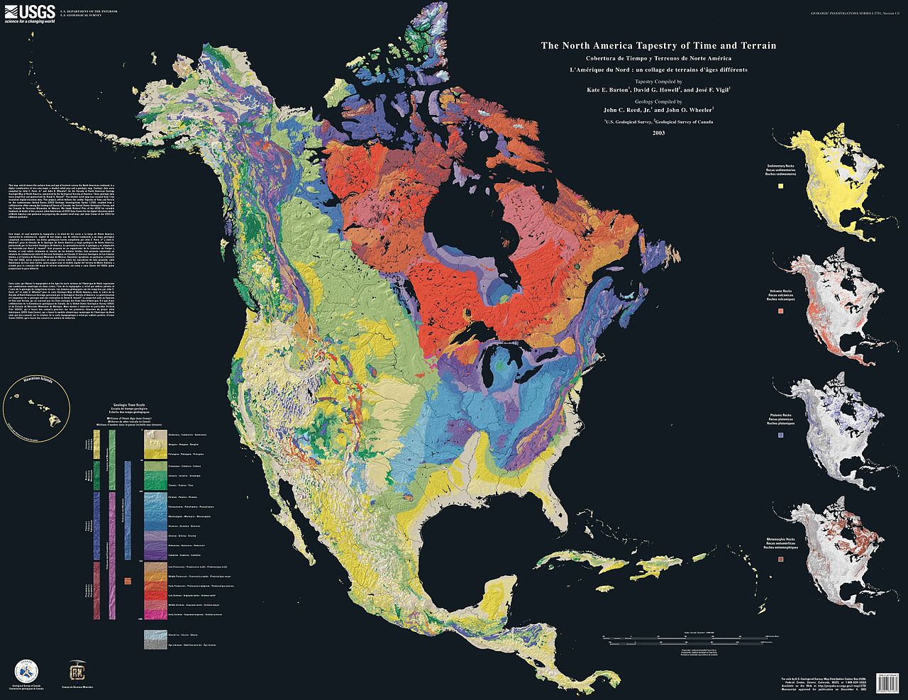
The North America Tapestry of Time and Terrain (1:8,000,000 scale) is a product of the United States Geological Survey in the I-map series (I-2781). This map was prepared in collaboration with the Geological Survey of Canada and the Mexican Consejo Recursos de Minerales.
This cartographic tapestry is woven from a geologic map and a shaded relief image. This digital combination reveals the geologic history of North America through the interrelation of rock type, topography and time. Regional surface processes as well as continent-scale tectonic events are exposed in the three dimensions of space and the fourth dimension, geologic time. The large map shows the varying age of bedrock underlying North America, while four smaller maps show the distribution of four principal types of rock: sedimentary, volcanic, plutonic and metamorphic.
Related images
Four maps show the North American distribution of four principal types of rock: sedimentary, volcanic, plutonic and metamorphic.


There are separate images of the main map, time scale, and rock type maps.
-
 North American terrain
 -
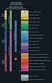 Time scale
 -
 North American rock types


Source
Dieses Bild ist gemeinfrei (public domain), weil es Materialien beeinhaltet, die ursprünglich vom United States Geological Survey, einer Behörde des Innenministeriums der Vereinigten Staaten, stammen. Weitere Informationen finden Sie in den Urheberrechtsbestimmungen des USGS
|
Home: http://pubs.usgs.gov/imap/i2781/
Image: http://pubs.usgs.gov/imap/i2781/i2781_c_low.pdf 144 dpi, encoded to 72 dpi JPEG, compressed slightly to fit within Wikipedia 2MB limit.
Source: English Wikipedia, original upload 15 April 2005 by SEWilco
Dateiversionen
Klicke auf einen Zeitpunkt, um diese Version zu laden.
| Version vom | Vorschaubild | Maße | Benutzer | Kommentar | |
|---|---|---|---|---|---|
| aktuell | 18:04, 16. Sep. 2005 | | 3.790 × 2.922 (1,9 MB) | Saperaud~commonswiki | The North America Tapestry of Time and Terrain (1:8,000,000 scale) is a product of the United States Geological Survey in the I-map series (I-2781). This map was prepared in collaboration with the Geological Survey of Canada and the [[Mexican |
Dateiverwendung
Die folgende Seite verwendet diese Datei:
Globale Dateiverwendung
Die nachfolgenden anderen Wikis verwenden diese Datei:
- Verwendung auf en.wikipedia.org
- Verwendung auf en.wikiversity.org
- Verwendung auf fa.wikipedia.org
- Verwendung auf ja.wikipedia.org
- Verwendung auf www.wikidata.org