Datei:Subtropical Storm Andrea (2007).JPG

Originaldatei (5.600 × 7.200 Pixel, Dateigröße: 6,76 MB, MIME-Typ: image/jpeg)
![]()
Diese Datei und die Informationen unter dem roten Trennstrich werden aus dem zentralen Medienarchiv Wikimedia Commons eingebunden.
![]()
Beschreibung
| Beschreibung |
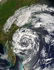
The circling clouds of an intense low-pressure system sat off the southeast coast of the United States on May 8, 2007, when the Moderate Resolution Imaging Spectroradiometer (MODIS) on NASA’s Terra satellite captured this image. By the following morning, the storm had developed enough to be classified as a subtropical storm, a storm that forms outside of the tropics, but has many of the characteristics—hurricane-force winds, driving rains, low pressure, and sometimes an eye—of a tropical storm. Although it arrived several weeks shy of the official start of the hurricane season (June 1), Subtropical Storm Andrea became the first named storm of the 2007 Atlantic hurricane season. The storm has the circular shape of a tropical cyclone in this image, but lacks the tight organization seen in more powerful storms. By May 9, the storm’s winds reached 75 kilometers per hour (45 miles per hour), and the storm was not predicted to get any stronger, said the National Hurricane Center. Though Subtropical Storm Andrea was expected to remain offshore, its strong winds and high waves pummeled coastal states, prompting a tropical storm watch. The winds fueled wild fires (marked with red boxes) in Georgia and Florida. The wind-driven flames generated thick plumes of smoke that concentrated in a gray-brown mass over Tampa Bay, Florida. Unfortunately for Georgia and Florida, which are experiencing moderate to severe drought, Subtropical Storm Andrea was not predicted to bring significant rain to the region right away, according to reports on the Washington Post Website. |
|||||
| Datum | ||||||
| Quelle | http://eob.gsfc.nasa.gov/NaturalHazards/natural_hazards_v2.php3?img_id=14254 | |||||
| Urheber | NASA/GSFC, MODIS Rapid Response | |||||
| Genehmigung (Weiternutzung dieser Datei) |
|

.JPG?uselang=de)
Dateiversionen
Klicke auf einen Zeitpunkt, um diese Version zu laden.
| Version vom | Vorschaubild | Maße | Benutzer | Kommentar | |
|---|---|---|---|---|---|
| aktuell | 18:26, 24. Mai 2019 | | 5.600 × 7.200 (6,76 MB) | Nino Marakot | Reverted to version as of 17:54, 24 May 2007 (UTC) - Gallery version |
| 20:48, 6. Dez. 2018 |  | 6.401 × 8.401 (10,1 MB) | FleurDeOdile | 250m | |
| 02:41, 26. Mär. 2018 |  | 1.700 × 2.100 (804 KB) | CooperScience | Centering, contrast and coloring fixes (From EOSDIS Worldview) | |
| 19:54, 24. Mai 2007 |  | 5.600 × 7.200 (6,76 MB) | Tom | higher res | |
| 03:09, 21. Mai 2007 |  | 538 × 558 (86 KB) | Hurricanehink | {{Information |Description=The circling clouds of an intense low-pressure system sat off the southeast coast of the United States on May 8, 2007, when the Moderate Resolution Imaging Spectroradiometer (MODIS) on NASA’s Terra satellite captured this imag |
Dateiverwendung
Die folgenden 2 Seiten verwenden diese Datei:
Globale Dateiverwendung
Die nachfolgenden anderen Wikis verwenden diese Datei:
- Verwendung auf en.wikipedia.org
- Verwendung auf eu.wikipedia.org
- Verwendung auf fr.wikipedia.org
- Verwendung auf he.wikipedia.org
- Verwendung auf pt.wikipedia.org
- Verwendung auf simple.wikipedia.org
- Verwendung auf sv.wikipedia.org
- Verwendung auf zh.wikipedia.org
.JPG)