Datei:Luitpold Coast.svg
Zur Navigation springen
Zur Suche springen

Größe der PNG-Vorschau dieser SVG-Datei: 800 × 590 Pixel. Weitere aus SVG automatisch erzeugte PNG-Grafiken in verschiedenen Auflösungen: 320 × 236 Pixel | 640 × 472 Pixel | 1.024 × 755 Pixel | 1.280 × 944 Pixel | 2.560 × 1.888 Pixel | 1.387 × 1.023 Pixel
Originaldatei (SVG-Datei, Basisgröße: 1.387 × 1.023 Pixel, Dateigröße: 4,52 MB)
Dateiversionen
Klicke auf einen Zeitpunkt, um diese Version zu laden.
| Version vom | Vorschaubild | Maße | Benutzer | Kommentar | |
|---|---|---|---|---|---|
| aktuell | 00:40, 26. Jul. 2020 |  | 1.387 × 1.023 (4,52 MB) | Hogweard | Wider context |
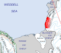
| 00:37, 26. Jul. 2020 |  | 885 × 765 (4,52 MB) | Hogweard | == {{int:filedesc}} == {{Information |description=Location of the Luitpold Coast of Coats Land, in the British Antarctic Territory |date=2020-07-26 |source={{f|Map of Queen Elizabeth Land, BAT.svg}} |author={{u|Hogweard}} |permission={{PD-self}} |other versions= }} Category:Maps of the British Antarctic Territory Category:Coats Land |
Dateiverwendung
Die folgenden 2 Seiten verwenden diese Datei: