| [2]
|
Name[3]
|
Bild
|
Eintragsdatum
|
Lage
|
Ort
|
Beschreibung
|
| 1
|
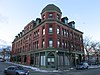
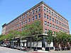
Acushnet Heights Historic District
|
 Acushnet Heights Historic District Acushnet Heights Historic District
|
1. Dez. 1989
ID-Nr. 89002035
|
41° 38′ 52″ N, 70° 55′ 53″ W41.647778-70.931389
| New Bedford |
|
| 2
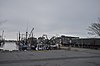
|
Butler Flats Light
|
 Butler Flats Light Butler Flats Light
|
15. Juni 1987
ID-Nr. 87001530
|
New Bedford Channel
41° 36′ 7″ N, 70° 53′ 54″ W41.601944-70.898333
| New Bedford |
|
| 3
|
Buttonwood Park Historic District
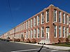
|
 Buttonwood Park Historic District Buttonwood Park Historic District
|
24. Aug. 2000
ID-Nr. 00000915
|
Kempton St., Rockdale Ave., Hawthorne St. und Brownell Ave.
41° 37′ 55″ N, 70° 57′ 7″ W41.631944-70.951944
| New Bedford |
|
| 4
|
Sgt. William H. Carney House
|
 Sgt. William H. Carney House Sgt. William H. Carney House
|
21. Apr. 1975
ID-Nr. 75000243
|
128 Mill St.
41° 38′ 15″ N, 70° 55′ 59″ W41.6375-70.933056
| New Bedford |
|
| 5
|
Central New Bedford Historic District
|
 Central New Bedford Historic District Central New Bedford Historic District
weitere Bilder
|
24. Apr. 1980
ID-Nr. 80000430
|
41° 38′ 6″ N, 70° 55′ 39″ W41.635-70.9275
| New Bedford |
|
| 6
|
County Street Historic District
|
 County Street Historic District County Street Historic District
|
11. Aug. 1976
ID-Nr. 76000229
|
41° 37′ 55″ N, 70° 55′ 55″ W41.631944-70.931944
| New Bedford |
|
| 7
|
Dawson Building
|
 Dawson Building Dawson Building
|
30. Sep. 1982
ID-Nr. 82001900
|
1851 Purchase St.
41° 39′ 0″ N, 70° 55′ 48″ W41.65-70.93
| New Bedford |
|
| 8
|
Thomas Donaghy School
|
 Thomas Donaghy School Thomas Donaghy School
|
2. März 1989
ID-Nr. 89000041
|
68 South St.
41° 37′ 33″ N, 70° 55′ 25″ W41.625833-70.923611
| New Bedford |
|
| 9
|
Ernestina (schooner)
|
 Ernestina (schooner) Ernestina (schooner)
weitere Bilder
|
3. Jan. 1985
ID-Nr. 85000022
|
Steamship Wharf
41° 38′ 1″ N, 70° 55′ 16″ W41.633611-70.921111
| New Bedford |
|
| 10
|
Fire Station No. 4
|
 Fire Station No. 4 Fire Station No. 4
|
24. Juli 1975
ID-Nr. 75000250
|
79 S. 6th St.
41° 37′ 41″ N, 70° 55′ 38″ W41.628056-70.927222
| New Bedford |
Heute Standort des New Bedford Fire Museum.
|
| 11
|
First Baptist Church
|
 First Baptist Church First Baptist Church
|
21. Apr. 1975
ID-Nr. 75000251
|
149 William St.
41° 38′ 6″ N, 70° 55′ 44″ W41.635-70.928889
| New Bedford |
|
| 12
|
Fort Taber District
|
 Fort Taber District Fort Taber District
|
8. Feb. 1973
ID-Nr. 73001954
|
41° 35′ 36″ N, 70° 54′ 14″ W41.593333-70.903889
| New Bedford |
|
| 13
|
Griffin Street Cemetery
|
 Griffin Street Cemetery Griffin Street Cemetery
|
19. März 2014
ID-Nr. 14000062
|
S. 2nd & Griffin Sts.
41° 37′ 42″ N, 70° 55′ 21,9″ W41.628323-70.922738
| New Bedford |
|
| 14
|
Hazelwood Park
|
 Hazelwood Park Hazelwood Park
|
24. Juni 2010
ID-Nr. 10000389
|
597-603 Brock Ave.
41° 36′ 24″ N, 70° 54′ 48″ W41.606667-70.913333
| New Bedford |
|
| 15
|
Head of the River Historic District
|
 Head of the River Historic District Head of the River Historic District
|
2. Dez. 2009
ID-Nr. 09000965
|
2-28 Mill Rd., 2-13 Tarkiln Hill Rd.
41° 40′ 54,2″ N, 70° 55′ 9,1″ W41.681736-70.919186
| New Bedford |
Erstreckt sich bis auf das Stadtgebiet von Acushnet.
|
| 16
|
Hotel Waverly
|
 Hotel Waverly Hotel Waverly
|
26. Jan. 1990
ID-Nr. 89002326
|
1162-1166 Acushnet Ave.
41° 39′ 26″ N, 70° 55′ 38″ W41.657222-70.927222
| New Bedford |
|
| 17
|
Howland Mill Village Historic District
|
 Howland Mill Village Historic District Howland Mill Village Historic District
|
30. Mai 1996
ID-Nr. 96000609
|
41° 36′ 58″ N, 70° 56′ 0″ W41.616111-70.933333
| New Bedford |
|
| 18
|
Robert C. Ingraham School
|
 Robert C. Ingraham School Robert C. Ingraham School
|
2. März 2010
ID-Nr. 10000056
|
80 Rivet St.
41° 37′ 14,2″ N, 70° 55′ 20,3″ W41.6206-70.9223
| New Bedford |
|
| 19
|
Jewish Cemetery
|
 Jewish Cemetery Jewish Cemetery
|
15. Apr. 2014
ID-Nr. 14000155
|
Old Plainville Road
41° 40′ 50,9″ N, 70° 58′ 1,2″ W41.6808-70.967
| New Bedford |
|
| 20
|
Nathan and Mary Johnson Properties
|
 Nathan and Mary Johnson Properties Nathan and Mary Johnson Properties
|
16. Feb. 2000
ID-Nr. 00000260
|
41° 37′ 59″ N, 70° 55′ 44″ W41.633056-70.928889
| New Bedford |
Standort der Underground Railroad
|
| 21
|
Lightship No. 114
|
|
30. Mai 1990
ID-Nr. 90000777
|
41° 38′ 8″ N, 70° 55′ 16″ W41.635556-70.921111
| New Bedford |
Im Mai 2007 verschrottet.
|
| 22
|
Manomet Mills
|
 Manomet Mills Manomet Mills
|
24. Mai 2012
ID-Nr. 12000304
|
194-194R, 200 Riverside Ave.
41° 40′ 3″ N, 70° 55′ 12,1″ W41.667494-70.920035
| New Bedford |
|
| 23
|
Merrill’s Wharf Historic District
|
 Merrill’s Wharf Historic District Merrill’s Wharf Historic District
|
11. Nov. 1977
ID-Nr. 77000167
|
MacArthur Dr.
41° 37′ 59″ N, 70° 55′ 15″ W41.633056-70.920833
| New Bedford |
|
| 24
|
Moreland Terrace Historic District
|
 Moreland Terrace Historic District Moreland Terrace Historic District
|
3. Juni 1996
ID-Nr. 96000610
|
41° 37′ 40″ N, 70° 56′ 11″ W41.627778-70.936389
| New Bedford |
|
| 25
|
New Bedford Gas and Edison Light Complex
|
 New Bedford Gas and Edison Light Complex New Bedford Gas and Edison Light Complex
|
3. Juni 2002
ID-Nr. 02000633
|
180 MacArthur Dr.
41° 37′ 49″ N, 70° 55′ 16″ W41.630278-70.921111
| New Bedford |
|
| 26
|
New Bedford Historic District
|
 New Bedford Historic District New Bedford Historic District
weitere Bilder
|
13. Nov. 1966
ID-Nr. 66000773
|
41° 38′ 7″ N, 70° 55′ 27″ W41.635278-70.924167
| New Bedford |
|
| 27
|
New Bedford Whaling National Historical Park
|
 New Bedford Whaling National Historical Park New Bedford Whaling National Historical Park
|
12. Nov. 1996
ID-Nr. 03000283
|
33 William St.
41° 38′ 8,5″ N, 70° 55′ 26,6″ W41.635692-70.924064
| New Bedford |
|
| 28
|
North Bedford Historic District
|
 North Bedford Historic District North Bedford Historic District
|
19. Sep. 1979
ID-Nr. 00000899
|
41° 38′ 25″ N, 70° 55′ 49″ W41.640278-70.930278
| New Bedford |
|
| 29
|
Oak Grove Cemetery
|
 Oak Grove Cemetery Oak Grove Cemetery
|
28. Apr. 2014
ID-Nr. 14000176
|
Parker St.
41° 38′ 37,3″ N, 70° 56′ 31,9″ W41.6437-70.9422
| New Bedford |
|
| 30
|
Old Third District Courthouse
|
 Old Third District Courthouse Old Third District Courthouse
|
28. Sep. 1971
ID-Nr. 71000083
|
2nd und William Sts.
41° 38′ 9″ N, 70° 55′ 29″ W41.635833-70.924722
| New Bedford |
|
| 31
|
Palmer Island Light Station
|
 Palmer Island Light Station Palmer Island Light Station
|
26. März 1980
ID-Nr. 80000433
|
New Bedford Harbor
41° 37′ 34″ N, 70° 54′ 35″ W41.626111-70.909722
| New Bedford |
|
| 32
|
William J. Rotch Gothic Cottage
|
 William J. Rotch Gothic Cottage William J. Rotch Gothic Cottage
weitere Bilder
|
17. Feb. 2006
ID-Nr. 06000236
|
19 Irving St.
41° 37′ 49,8″ N, 70° 55′ 54,5″ W41.630494-70.931811
| New Bedford |
|
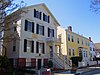
| 33
|
William Rotch, Jr. House
|
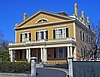 William Rotch, Jr. House William Rotch, Jr. House
weitere Bilder
|
5. Apr. 2005
ID-Nr. 05000456
|
396 County Street
41° 37′ 49,1″ N, 70° 55′ 43,3″ W41.630297-70.928686
| New Bedford |
|
| 34
|
Rural Cemetery and Friends Cemetery
|
 Rural Cemetery and Friends Cemetery Rural Cemetery and Friends Cemetery
|
28. Apr. 2014
ID-Nr. 14000177
|
149 Dartmouth St.
41° 37′ 22,4″ N, 70° 56′ 7,4″ W41.6229-70.9354
| New Bedford |
|
| 35
|
Shawmut Diner
|
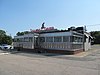 Shawmut Diner Shawmut Diner
|
28. Nov. 2003
ID-Nr. 03001208
|
943 Shawmut Ave.
41° 39′ 32″ N, 70° 56′ 51″ W41.658889-70.9475
| New Bedford |
|
| 36
|
Bradford Smith Building
|
|
17. Mai 1984
ID-Nr. 84002216
|
1927-1941 Purchase St.
41° 39′ 4″ N, 70° 55′ 49″ W41.651111-70.930278
| New Bedford |
Nicht mehr existent.
|
| 37
|
Thompson Street School
|
 Thompson Street School Thompson Street School
|
26. Jan. 1990
ID-Nr. 89002329
|
58 Crapo St.
41° 37′ 17″ N, 70° 55′ 37″ W41.621389-70.926944
| New Bedford |
|
| 38
|
Times and Olympia Buildings
|
 Times and Olympia Buildings Times and Olympia Buildings
|
7. Juli 1983
ID-Nr. 83000725
|
908-912 und 880-898 Purchase St.
41° 38′ 11″ N, 70° 55′ 36″ W41.636389-70.926667
| New Bedford |
|
| 39
|
U.S. Customhouse
|
 U.S. Customhouse U.S. Customhouse
weitere Bilder
|
30. Dez. 1970
ID-Nr. 70000735
|
41° 38′ 7″ N, 70° 55′ 29″ W41.635278-70.924722
| New Bedford |
|
| 40
|
Union Baptist Church
|
 Union Baptist Church Union Baptist Church
|
16. Juni 2008
ID-Nr. 08000532
|
109 Court St.
41° 38′ 3,1″ N, 70° 56′ 5,2″ W41.634181-70.934775
| New Bedford |
|
| 41
|
Union Street Railway Carbarn, Repair Shop
|
 Union Street Railway Carbarn, Repair Shop Union Street Railway Carbarn, Repair Shop
|
2. Okt. 1978
ID-Nr. 78000431
|
1959 Purchase St.
41° 39′ 7″ N, 70° 55′ 52″ W41.651944-70.931111
| New Bedford |
|
| 42
|
Wamsutta Mills
|
 Wamsutta Mills Wamsutta Mills
|
19. Aug. 2008
ID-Nr. 08000794
|
Acushnet Ave., Logan, Wamsutta und N. Front St.
41° 39′ 5,3″ N, 70° 55′ 39,5″ W41.651479-70.927627
| New Bedford |
|
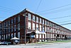
| 43
|
Whitman Mills
|
 Whitman Mills Whitman Mills
|
29. Aug. 2003
ID-Nr. 03000844
|
41° 39′ 45″ N, 70° 55′ 10″ W41.6625-70.919444
| New Bedford |
|


