Benutzer:Vorwald/The Black Tusk
| The Black Tusk | ||
|---|---|---|

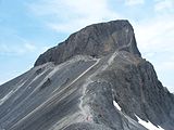
The Black Tusk von Südosten | ||
| Höhe | 2319 m ü. d. Meeresspiegel[1]Vorlage:Höhe/unbekannter Bezug | |
| Lage | New Westminster Land District | |
| Gebirge | Garibaldi Ranges, Pacific Ranges, Coast Mountains | |
| Schartenhöhe | 569 m | |
| Koordinaten | 49° 58′ 31″ N, 123° 2′ 34″ W | |
| Topo-Karte | Geospatial Data Extraction | |
| ||
| Typ | Stratovulkan | |
| Alter des Gesteins | Pleistozän | |
| Letzte Eruption | Pleistozän | |
| Erstbesteigung | 1912 durch William J. Gray und Seilschaft[2] | |
| Normalweg | Fels-Kraxeln | |

The Black Tusk, in der Sprache der St'at'imcets (Lillooet) Q̓elqámtensa ti Skenknápa und in der Sprache der Sḵwx̱wú7mesh (Squamish) T'ákt'akmúten tl'a Ín7inyáx̱a7en, ist ein 2319 m[2] hoher Stratovulkan und eine Nadel aus Vulkangestein mit einer Schartenhöhe von 569 m.[2] Er liegt im Garibaldi Provincial Park in der kanadischen Provinz British Columbia.
Lage
[Bearbeiten | Quelltext bearbeiten]Durch seine Höhe und Lage bedingt, ist die oberste Spitze des Black Tusk aus großer Entfernung aus allen Richtungen zu sehen. Besonders bemerkenswert ist er vom Sea-to-Sky Highway südlich von Whistler aus. Durch seine Einzigartigkeit gehört er er zu den bestbekannten Bergen der Garibaldi Ranges in den Coast Mountains. Der Vulkan ist Teil des Garibaldi Volcanic Belt, eines Abschnitts der kanadischen Kaskaden-Vulkane, liegt jedoch nicht innerhalb der geografischen Grenzen der Kaskadenkette.
Indigenous
[Bearbeiten | Quelltext bearbeiten]The mountain traditionally is part of the border line between the Squamish and Lil'wat nations. To the Squamish people, this mountain is known as T'ákt'akmúten tl'a Ín7inyáx̱a7en, which means "Landing Place of the Thunderbird", speaking of the supernatural Ín7inyáx̱a7en or Thunderbird. The jagged shape of the mountain and its black colouring are said to come from the Thunderbird's lightning.[3] The same is true for Mount Cayley, another stratovolcano farther north.
Geology
[Bearbeiten | Quelltext bearbeiten]The Black Tusk is considered to be the remnant of an extinct andesitic stratovolcano which formed between about 1.3 and 1.1 million years ago.[4] Following glacial dissection, renewed volcanism produced the lava dome and flow forming its summit about 170,000 years ago. According to Natural Resources Canada, The Black Tusk was "perhaps the conduit for lava within a cinder-rich volcano. The loose cinder has eroded, leaving only the hard lava core."[5] The exposed lava rock of the core is loose and friable. It is also black, giving the mountain its name and character. Cinder Cone, to the east of The Black Tusk, produced a Vorlage:Convert long lava flow during the late Pleistocene or early Holocene.
The mountain currently hosts two significant glaciers, in large cirques carved into the northeastern and northwestern flanks of the broad cone below the lava pinnacle. Both glaciers start from about Vorlage:Convert and flow northwards to below Vorlage:Convert. The glaciers are heavily covered in rocky debris due to the crumbling nature of the Tusk's rock.
The Black Tusk is a member of the chain of volcanic peaks that run from southwestern British Columbia to northern California. The peaks formed in the past 35 million years as the Juan de Fuca, Gorda and Explorer plates to its west have been subducting under the North American Plate at the Cascadia subduction zone.
Recreation
[Bearbeiten | Quelltext bearbeiten]The Black Tusk's lower flanks and south summit are a popular backcountry hiking and scrambling destination. Most hikers approach from the Taylor Meadows campground to the south near Garibaldi Lake, although there is a second route from the north that travels by way of Helm Lake.[6]
The upper summit area at the top of the lava column can only be reached by scrambling up a short but exposed rock chimney to reach the south summit.[1] The true summit, only about a metre higher, lies just to the north across a precipitous drop. It is rarely climbed, requiring a rappel of about Vorlage:Convert into a notch followed by a loose and dangerous reascent up the crumbling lava. On the northern side of the north summit stands an isolated and intimidating rock formation known as the "Bishop's Mitre", which is rumoured to be unclimbed.[3] [7]
-
 Part of the trail from Garibaldi Lake to The Black Tusk.
 -
 Close-up view of The Black Tusk.
 -
 The Black Tusk as seen from the top of the Peak Express at Whistler Blackcomb


See also
[Bearbeiten | Quelltext bearbeiten]- Cascade Volcanoes
- Garibaldi Volcanic Belt
- List of volcanoes in Canada
- Volcanism of Canada
- Liste der Berge in Kanada
External links
[Bearbeiten | Quelltext bearbeiten]- Vorlage:Cite bivouac
- Vorlage:Cite bcgnis
- Black Tusk. Catalogue of Canadian volcanoes, archiviert vom am 16. Juli 2011.
- Garibaldi Provincial Park (Black Tusk/Garibaldi Lake Area)
- Vorlage:Cite gvp
- Natural Resources Canada (Garibaldi: Where Fire Met Ice)
einzelnachweise
[Bearbeiten | Quelltext bearbeiten]- ↑ a b Gunn, Matt: Scrambles in Southwest British Columbia. Cairn Publishing, 2005, ISBN 0-9735489-0-8, S. 78 (englisch, cairnpublishing.com).
- ↑ a b c The Black Tusk. Abgerufen am 28. Juni 2024 (englisch, Login erforderlich).
- ↑ a b The Black Tusk. In: Canadian Mountain Encyclopedia. Abgerufen am 18. Februar 2007 (englisch).
- ↑ Catalogue of Canadian volcanoes - Black Tusk. National Resources Canada, archiviert vom am 16. Juli 2011 (englisch).
- ↑ Garibaldi: Where Fire Met Ice. In: Geological Survey of Canada. Archiviert vom am 22. Mai 2010; abgerufen am 18. Februar 2007 (englisch).
- ↑ Garibaldi Provincial Park - Black Tusk/Garibaldi Lake Area. In: BC Parks. Archiviert vom am 29. Juni 2007; abgerufen am 18. Februar 2007 (englisch).
- ↑ The Bishop's Mitre. In: Canadian Mountain Encyclopedia. Abgerufen am 18. Februar 2007 (englisch).
Vorlage:Clear
Vorlage:Pacific Ranges
Vorlage:Garibaldi Volcanic Belt
[[Category:Religious places of the Indigenous peoples of North America]] [[Category:Stratovolcanoes of Canada]] [[Category:Two-thousanders of British Columbia]] [[Category:Volcanoes of British Columbia]] [[Category:Subduction volcanoes]] [[Category:Squamish people]] [[Category:Sacred mountains of the Americas]] [[Category:Extinct volcanoes of North America]] [[Category:Pleistocene volcanoes]] [[Category:Sea-to-Sky Corridor]] [[Category:Polygenetic volcanoes]] [[Category:Garibaldi Ranges]] [[Category:Garibaldi Lake volcanic field]] [[Category:Pleistocene British Columbia]]