Datei:Estuaries, Northwest Coast of Madagascar.JPG
Zur Navigation springen
Zur Suche springen
Größe dieser Vorschau: 398 × 599 Pixel. Weitere Auflösungen: 159 × 240 Pixel | 319 × 480 Pixel | 510 × 768 Pixel | 680 × 1.024 Pixel | 1.360 × 2.048 Pixel | 2.848 × 4.288 Pixel
Originaldatei (2.848 × 4.288 Pixel, Dateigröße: 13,29 MB, MIME-Typ: image/jpeg)
![]()
Diese Datei und die Informationen unter dem roten Trennstrich werden aus dem zentralen Medienarchiv Wikimedia Commons eingebunden.
![]()
Beschreibung
| Beschreibung |
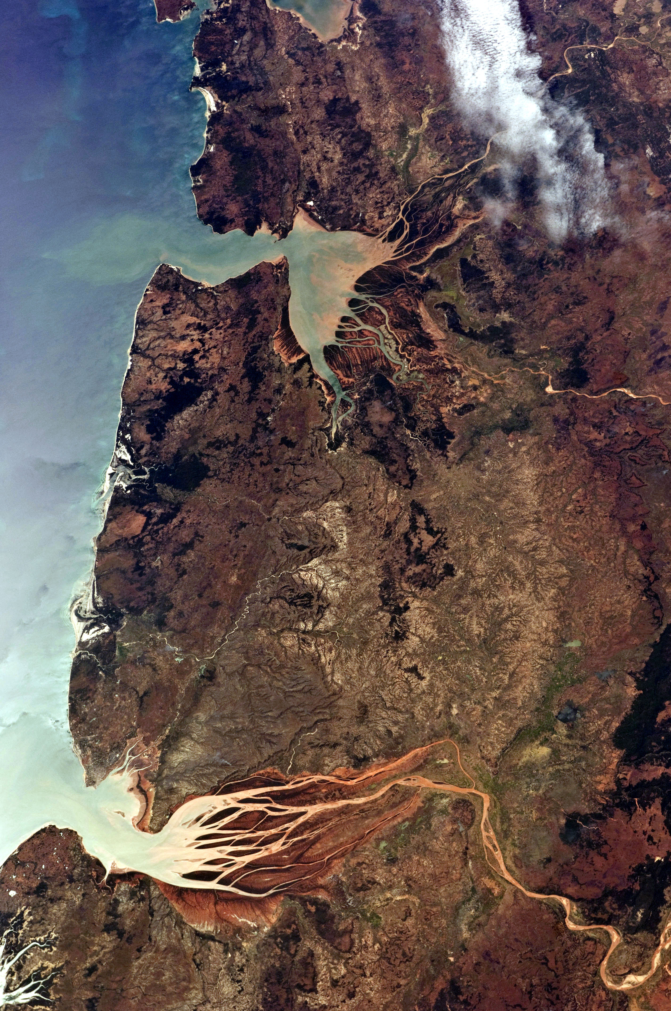
English: This astronaut photograph, taken from the International Space Station, highlights two estuaries along the north-western coastline of Madagascar. Bombetoka Bay (image upper left) is fed by the Betsiboka River, and is a frequent subject of astronaut photography due to its striking red floodplain sediments. Mahajamba Bay (image right) is fed by several rivers, including the Mahajamba and Sofia. |
| Datum | |
| Quelle | NASA Earth Observatory |
| Urheber | ISS Astronaut photograph |
| Kameraposition | | Dieses und weitere Bilder auf OpenStreetMap |
|---|
Diese Mediendatei wurde vom Johnson Space Center der US-amerikanischen National Aeronautics and Space Administration (NASA) unter der Datei-ID ISS028-E-6687 kategorisiert. Diese Markierung zeigt nicht den Urheberrechtsstatus des zugehörigen Werks an. Es ist in jedem Falle zusätzlich eine normale Lizenzvorlage erforderlich. Siehe Commons:Lizenzen für weitere Informationen. Sprachen:
|
Lizenz
| Diese Datei ist gemeinfrei (public domain), da sie von der NASA erstellt worden ist. Die NASA-Urheberrechtsrichtlinie besagt, dass „NASA-Material nicht durch Urheberrecht geschützt ist, wenn es nicht anders angegeben ist“. (NASA-Urheberrechtsrichtlinie-Seite oder JPL Image Use Policy). | ||
 |
Warnung:
|
| Bildnotizen | Diese Datei ist annotiert: Betrachte diese auf Commons. |
Dateiversionen
Klicke auf einen Zeitpunkt, um diese Version zu laden.
| Version vom | Vorschaubild | Maße | Benutzer | Kommentar | |
|---|---|---|---|---|---|
| aktuell | 10:00, 16. Mai 2021 | | 2.848 × 4.288 (13,29 MB) | SteinsplitterBot | Bot: Image rotated by 270° |
| 13:30, 13. Jun. 2011 |  | 4.288 × 2.848 (13,3 MB) | Originalwana | {{Information |Description ={{en|1=This astronaut photograph, taken from the International Space Station, highlights two estuaries along the north-western coastline of Madagascar. Bombetoka Bay (image upper left) is fed by the [[:Category:Betsiboka |
Dateiverwendung
Die folgende Seite verwendet diese Datei:
Globale Dateiverwendung
Die nachfolgenden anderen Wikis verwenden diese Datei:
- Verwendung auf en.wikipedia.org
- Verwendung auf et.wikipedia.org
- Verwendung auf fr.wikipedia.org
- Verwendung auf ha.wikipedia.org
- Verwendung auf mg.wikipedia.org
- Verwendung auf ml.wikipedia.org
- Verwendung auf nl.wikipedia.org
- Verwendung auf pl.wikipedia.org
- Verwendung auf pt.wikipedia.org
- Verwendung auf ro.wikipedia.org
- Verwendung auf ru.wikipedia.org
- Verwendung auf sh.wikipedia.org
- Verwendung auf sl.wikipedia.org
- Verwendung auf sr.wikipedia.org
- Verwendung auf zh.wikipedia.org