Datei:Landsat GlacierBay 01aug99.jpg
Zur Navigation springen
Zur Suche springen

Größe dieser Vorschau: 800 × 480 Pixel. Weitere Auflösungen: 320 × 192 Pixel | 1.024 × 614 Pixel | 1.280 × 768 Pixel | 2.560 × 1.536 Pixel | 7.500 × 4.500 Pixel
Originaldatei (7.500 × 4.500 Pixel, Dateigröße: 4,04 MB, MIME-Typ: image/jpeg)
![]()
Diese Datei und die Informationen unter dem roten Trennstrich werden aus dem zentralen Medienarchiv Wikimedia Commons eingebunden.
![]()
Beschreibung
| Beschreibung | 3D visualization of Landsat imagery of Glacier Bay National Park and Preserve |
| Datum | |
| Quelle | Visible Earth - http://visibleearth.nasa.gov/view_rec.php?id=16657 |
| Urheber | Landsat Project Science Office at NASA’s Goddard Space Flight Center |
| Genehmigung (Weiternutzung dieser Datei) |
PD |
From the source page:
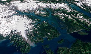
- The water in the foreground in the southwest (bottom left) corner of the image is the Gulf of Alaska, with Icy Strait running roughly west to east (horizontally) in from Cape Spencer where the strait meets the Pacific. The foreground glacier is the Brady Glacier. The light gray feature at the foot of the glacier is fine silt dropped by the glacier as it melts. The glacier’s meltwater washes the silt into the Strait, coloring the shallow waters light blue as the silt mixes. The long finger of water dominating the entire scene is Glacier Bay itself. The two points of land at the beginning of the Bay are roughly where the Grand Pacific Glacier ended when George Vancouver’s crew surveyed the area. The Grand Pacific Glacier now terminates well above Tar Inlet, the finger of water stretching furthermost north (up) at the top of Glacier Bay. The first major inlet on the east (right) coming up from the mouth of Glacier Bay is Muir Inlet. The glaciers feeding into the bay terminated here around 1860. The body of water paralleling the Bay on the eastern edge is Lynn Canal, a body of water also draining into Icy Strait beyond the eastern boundary of the park.
- The image above is a visualization created by merging imagery from the Landsat 7 satellite’s Enhanced Thematic Mapper Plus (ETM+) instrument with elevation data from the USGS National Elevation Dataset (NED). This true-color image was created by combining the red, green, and blue wavelengths (ETM+ bands 3, 2, and 1). The resulting image was then draped over a visualization of the NED data with no vertical exaggeration. The USGS NED is a merged data product created from from several sources, prodominately 30-meter resolution elevation data collected by NASA’s Shuttle Radar Topography Mission (SRTM).
Lizenz
| Diese Datei ist gemeinfrei (public domain), da sie von der NASA erstellt worden ist. Die NASA-Urheberrechtsrichtlinie besagt, dass „NASA-Material nicht durch Urheberrecht geschützt ist, wenn es nicht anders angegeben ist“. (NASA-Urheberrechtsrichtlinie-Seite oder JPL Image Use Policy). | ||
 |
Warnung:
|
Dateiversionen
Klicke auf einen Zeitpunkt, um diese Version zu laden.
| Version vom | Vorschaubild | Maße | Benutzer | Kommentar | |
|---|---|---|---|---|---|
| aktuell | 04:41, 11. Sep. 2006 | | 7.500 × 4.500 (4,04 MB) | Davepape | {{Information |Description=3D visualization of Landsat imagery of Glacier Bay National Park and Preserve |Source=Visible Earth - http://visibleearth.nasa.gov/view_rec.php?id=16657 |Date= 2003-12-07 |Author= Lan |
Dateiverwendung
Die folgende Seite verwendet diese Datei:
Globale Dateiverwendung
Die nachfolgenden anderen Wikis verwenden diese Datei:
- Verwendung auf ar.wikipedia.org
- Verwendung auf ceb.wikipedia.org
- Verwendung auf cs.wikipedia.org
- Verwendung auf en.wikipedia.org
- Verwendung auf eo.wikipedia.org
- Verwendung auf es.wikipedia.org
- Verwendung auf fr.wikipedia.org
- Verwendung auf he.wikipedia.org
- Verwendung auf hr.wikipedia.org
- Verwendung auf it.wikipedia.org
- Verwendung auf ja.wikipedia.org
- Verwendung auf pt.wikipedia.org
- Verwendung auf ru.wikipedia.org
- Verwendung auf sr.wikipedia.org
- Verwendung auf sv.wikipedia.org
- Verwendung auf tr.wikipedia.org
- Verwendung auf uk.wikipedia.org
- Verwendung auf uz.wikipedia.org
- Verwendung auf vec.wikipedia.org
- Verwendung auf www.wikidata.org