Datei:Philippines.A2002088.0220.1km.jpg

Originaldatei (1.150 × 1.500 Pixel, Dateigröße: 417 KB, MIME-Typ: image/jpeg)
![]()
Diese Datei und die Informationen unter dem roten Trennstrich werden aus dem zentralen Medienarchiv Wikimedia Commons eingebunden.
![]()
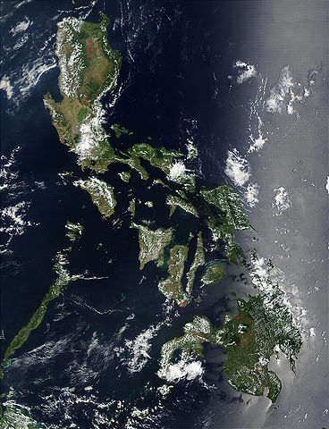
Credit: Jacques Descloitres, MODIS Land Rapid Response Team, NASA/GSFC
Red dots (or outlines in the high-resolution imagery) indicate MODIS9 detection of thermal anomalies throughout the Philippines on March 29, 2002. In most cases, the anomaly is a fire, for example, all the locations marked on the northernmost island, Luzon. However, south of center, on the southern tip of Negros, the thermal anomaly is likely volcanic activity, and the red dot left of center of the main part of Mindanao (lower right) marks the location of a volcano called Mount Ragang.
http://visibleearth.nasa.gov/view_rec.php?id=2656
| Diese Datei ist gemeinfrei (public domain), da sie von der NASA erstellt worden ist. Die NASA-Urheberrechtsrichtlinie besagt, dass „NASA-Material nicht durch Urheberrecht geschützt ist, wenn es nicht anders angegeben ist“. (NASA-Urheberrechtsrichtlinie-Seite oder JPL Image Use Policy). | ||
 |
Warnung:
|
Dateiversionen
Klicke auf einen Zeitpunkt, um diese Version zu laden.
| Version vom | Vorschaubild | Maße | Benutzer | Kommentar | |
|---|---|---|---|---|---|
| aktuell | 23:55, 25. Okt. 2005 | | 1.150 × 1.500 (417 KB) | Brian0918 | Credit: Jacques Descloitres, MODIS Land Rapid Response Team, NASA/GSFC Red dots (or outlines in the high-resolution imagery) indicate MODIS9 detection of thermal anomalies throughout the Philippines on March 29, 2002. In most cases, the anomaly is a fire |
Dateiverwendung
Die folgende Seite verwendet diese Datei:
Globale Dateiverwendung
Die nachfolgenden anderen Wikis verwenden diese Datei:
- Verwendung auf af.wikipedia.org
- Verwendung auf ar.wikipedia.org
- Verwendung auf ast.wikipedia.org
- Verwendung auf en.wikipedia.org
- Verwendung auf es.wikipedia.org
- Verwendung auf es.wiktionary.org
- Verwendung auf fr.wikipedia.org
- Verwendung auf hr.wikipedia.org
- Verwendung auf ilo.wikipedia.org
- Verwendung auf it.wikipedia.org
- Verwendung auf km.wikipedia.org
- Verwendung auf ko.wikipedia.org
- Verwendung auf nl.wikipedia.org
- Verwendung auf pl.wikipedia.org
- Verwendung auf pl.wikinews.org
- Verwendung auf pt.wikipedia.org
- Verwendung auf sh.wikipedia.org
- Verwendung auf sq.wikipedia.org
- Verwendung auf tl.wikipedia.org
- Verwendung auf uk.wikipedia.org