Datei:Antarctic Temperature Trend 1981-2007.jpg
Zur Navigation springen
Zur Suche springen
Es ist keine höhere Auflösung vorhanden.
Antarctic_Temperature_Trend_1981-2007.jpg (540 × 508 Pixel, Dateigröße: 93 KB, MIME-Typ: image/jpeg)
![]()
Diese Datei und die Informationen unter dem roten Trennstrich werden aus dem zentralen Medienarchiv Wikimedia Commons eingebunden.
![]()
Beschreibung
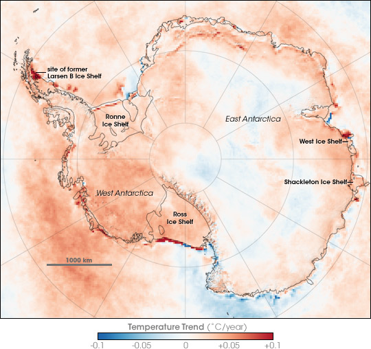
| Beschreibung | Map showing Antarctic Skin Temperature Trends between 1981 and 2007. Skin temperature is roughly the top one millimeter of land, sea, snow, or ice. Across most of the Antarctic the temperature increased, in some areas warming approaching 2 degrees Celsius during the period. The map is based on thermal infrared (heat) observations made by a series of NOAA satellite sensors. None of the sensors were in orbit at the same time, so scientists could not compare simultaneous observations from different sensors to make sure each was recording temperatures exactly the same. Instead, the team checked the satellite records against ground-based weather station data to inter-calibrate them and make the 26-year satellite record. The level of uncertainty is between 2 and 3 degrees Celsius. The most dramatic changes are the red areas associated with iceberg calving and the collapse of the Larsen B ice shelf. In these cases, the satellites saw a change from cold ice to relatively warm open water. |
| Datum | |
| Quelle | en:Internet Archive - https://web.archive.org/web/20070823123915/http://earthobservatory.nasa.gov/Newsroom/NewImages/images.php3?img_id=17838 (originally http://earthobservatory.nasa.gov/Newsroom/NewImages/images.php3?img_id=17838 NASA Earth Observatory) |
| Urheber | Robert Simmon |
| Andere Versionen | العربيَّة |
Lizenz
| Diese Datei ist gemeinfrei (public domain), da sie von der NASA erstellt worden ist. Die NASA-Urheberrechtsrichtlinie besagt, dass „NASA-Material nicht durch Urheberrecht geschützt ist, wenn es nicht anders angegeben ist“. (NASA-Urheberrechtsrichtlinie-Seite oder JPL Image Use Policy). | ||
 |
Warnung:
|
Dateiversionen
Klicke auf einen Zeitpunkt, um diese Version zu laden.
| Version vom | Vorschaubild | Maße | Benutzer | Kommentar | |
|---|---|---|---|---|---|
| aktuell | 00:13, 22. Nov. 2007 | | 540 × 508 (93 KB) | Sagredo | {{Information |Description=Map showing Antarctic Skin Surface Temperature Trends 1981-2007. Skin temperature is roughly the top one millimeter of land, sea, snow, or ice. Across most of the Antarctic the temperature increased, in some areas approachi |
Dateiverwendung
Keine Seiten verwenden diese Datei.
Globale Dateiverwendung
Die nachfolgenden anderen Wikis verwenden diese Datei:
- Verwendung auf ar.wikipedia.org
- Verwendung auf ast.wikipedia.org
- Verwendung auf ca.wikipedia.org
- Verwendung auf el.wikipedia.org
- Verwendung auf en.wikipedia.org
- Verwendung auf eo.wikipedia.org
- Verwendung auf es.wikipedia.org
- Verwendung auf gl.wikipedia.org
- Verwendung auf ja.wikipedia.org
- Verwendung auf mk.wikipedia.org
- Verwendung auf nl.wikipedia.org
- Verwendung auf nn.wikipedia.org
- Verwendung auf pa.wikipedia.org
- Verwendung auf pl.wikipedia.org
- Verwendung auf ur.wikipedia.org
- Verwendung auf vi.wikipedia.org
- Verwendung auf zh.wikipedia.org