Diskussion:Transhimalaya
Letzter Kommentar: vor 12 Jahren von Rupert Pupkin in Abschnitt Höchster Gipfel Transhimalaya - Ningchin Kangsha?
Höchster Gipfel Transhimalaya - Ningchin Kangsha?[Quelltext bearbeiten]
- Höchster Gipfel Transhimalaya - Ningchin Kangsha? Ningchin Kangsha (Norin Kang) is to suden from Brahmaputra. Its Himalayan peak. Sergoman 11:55, 1. Sep. 2011 (CEST)
- Anybody`s hier? Sergoman 17:25, 2. Sep. 2011 (CEST)
- Hello Sergoman, I think you're right. Additionally under »Gliederung« it seems to be contradictory, that the lower part Gangdisê has the higher peak (7223 m) in comparison to the higher chain Nyainqêntanglha (7162 m). But what is the highest summit of Transhimalaya? Greetings
Watzmann Disk. 15:14, 5. Sep. 2011 (CEST)- Guten Abend. Good question. Im no answer to it. I write articles about seventhousenth, and absorbed many information for Himalaya-Karakorum-China moun-s. And about this places I reed from childhood (~ 1986). In ruwiki highest point in article Гандисышань is semi-miphological Aling-Gangri (7315 m) taken from Great Soviet Encyclopedy. I simply walked along interwiks and saw explicit wrong in deutsch article. If I found any information during days, I`ll write here. Sergoman 18:59, 5. Sep. 2011 (CEST)
- Google doesn't help. The Website of Dr. Hartmut Bielefeldt also lists Ningchin Kangsha as highest peak of TH (#767), citing Jill Neate: "High Asia, an illustrated history of the 7,000 metre peaks", The Mountaineers, Seattle, 1989 as source. But this is probably false and a private website is no reference for us. 7162 m high Nyenchen Tangla is listed by Bielefeldt as second highest peak. Should we take this one for highest peak of TH? I don't know. Are there any other suggestions?
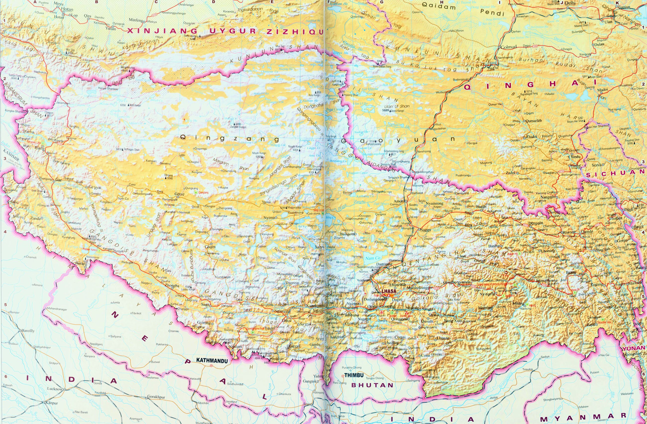
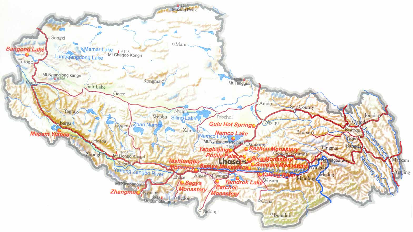
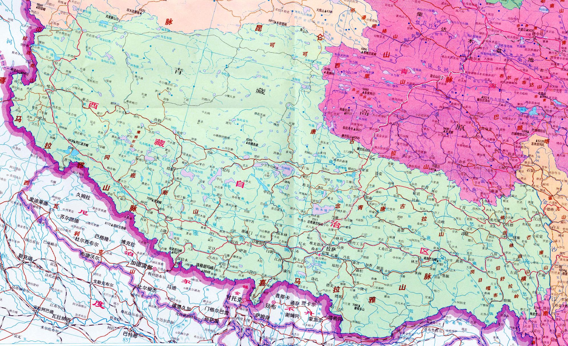
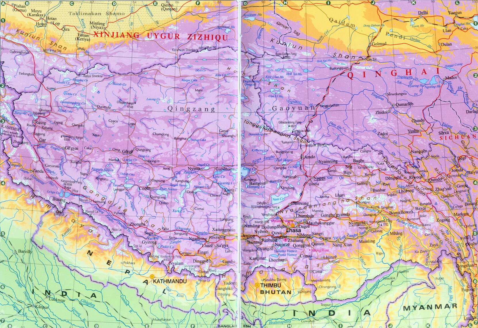
Watzmann Disk. 20:00, 5. Sep. 2011 (CEST)- In five little-unlittle refference maps 1, 2, 3, 4, 5 Gangdise Shan dispose to east only to Xigaze (Shigadse), Namling towns and Nyanchen Tangla not include in TransHimalaya. In those maps appoints Kailash (6656 m) and Loinbo Kangri (7095 m). And this mount is most probable pretender to highest peak (of coarse if not include Nyenchen Tangla). Sergoman 12:24, 6. Sep. 2011 (CEST)
- And paper refference to Lunpo Kangri. Sergoman 12:54, 6. Sep. 2011 (CEST)
- In five little-unlittle refference maps 1, 2, 3, 4, 5 Gangdise Shan dispose to east only to Xigaze (Shigadse), Namling towns and Nyanchen Tangla not include in TransHimalaya. In those maps appoints Kailash (6656 m) and Loinbo Kangri (7095 m). And this mount is most probable pretender to highest peak (of coarse if not include Nyenchen Tangla). Sergoman 12:24, 6. Sep. 2011 (CEST)
- Google doesn't help. The Website of Dr. Hartmut Bielefeldt also lists Ningchin Kangsha as highest peak of TH (#767), citing Jill Neate: "High Asia, an illustrated history of the 7,000 metre peaks", The Mountaineers, Seattle, 1989 as source. But this is probably false and a private website is no reference for us. 7162 m high Nyenchen Tangla is listed by Bielefeldt as second highest peak. Should we take this one for highest peak of TH? I don't know. Are there any other suggestions?
- Guten Abend. Good question. Im no answer to it. I write articles about seventhousenth, and absorbed many information for Himalaya-Karakorum-China moun-s. And about this places I reed from childhood (~ 1986). In ruwiki highest point in article Гандисышань is semi-miphological Aling-Gangri (7315 m) taken from Great Soviet Encyclopedy. I simply walked along interwiks and saw explicit wrong in deutsch article. If I found any information during days, I`ll write here. Sergoman 18:59, 5. Sep. 2011 (CEST)
- Hello Sergoman, I think you're right. Additionally under »Gliederung« it seems to be contradictory, that the lower part Gangdisê has the higher peak (7223 m) in comparison to the higher chain Nyainqêntanglha (7162 m). But what is the highest summit of Transhimalaya? Greetings

What about Aling Gangri, 7315 m, see here, the russian page Гандисышань and the following map, used in this article?
Watzmann Disk. 19:41, 6. Sep. 2011 (CEST)
- Sergoman is right, Noijinkangsang lies south of Brahmaputra/Tsangpo, you can clearly see it on the POSKARTE in the Infobox in the article.
- This map here on the right is not very accurate. It has this nameless 7723 m peak in the eastern KunLun. This is another "myth", there is no such mountain. Aling Kangri might be here: 32°48'25.03"N, 81° 0'3.50"E. I found it with google Earth, it's called Nganglong Kangri and seems to be higher than 6600 m, but far from 7000 m.
- My guess for the highest peak of the Transhimalayas is Gyalha Peri, west of Namcha Barwa. But I'm not too familiar with the whole area. best regards--Rupert Pupkin 22:49, 6. Sep. 2011 (CEST)
- You`re right. Aling Kangri = Nganglong Kangri (6720 m). What about Gyalha Peri, it with Namcha Barwa is East End of Himalaya. One of decision may be - do (by Law) Nyenchen Tangla as analogic East End of Transhimalayas. Sergoman 05:01, 7. Sep. 2011 (CEST)
- But Tsangpo/Brahmaputra seperates Gyahla Peri from Namcha Barwa. So geographically they may belong to different mountain ranges. English wikipedia says G.P. is part of Namcha Barwa range. I don't know. I thought the river was an important border.
- Same applies to Karakorams/Himalaya. Mount Haramosh lies north of Indus river and belongs to the Rakaposhi-Haramosh mountains in the Karakorams. Nanga Parbat rises from the southern shores of the Indus and is part of the Himalaya. Geologically however Haramosh and Nanga Parbat have much more in common than haramosh and his Karakoram neighbors... (but concerning namcha Barwa and Gyalha Peri I have to little information/knowledge whatever...). --Rupert Pupkin 00:36, 9. Sep. 2011 (CEST)
I have created the page for Nyainqêntanglha (Berg) and called it highest peak of the Transhimalayas. Its parent mountain concerning prominence is Gurla Mandhata in the Himalayas (just north east of Nepal). So there doesn't seem to be any higher peak in the Transhimalayas. But I'm still not sure about Gyalha Peri. And what is the highest peak of the Gangdisê? Noijinkangsang is obvioulsy wrong, see above. --Rupert Pupkin 13:28, 12. Sep. 2011 (CEST)
- Thank you, Rupert. One question: What about the double questionmark in Nyainqêntanglha (Berg)? Because you think it must be a goddess?
Watzmann Disk. 21:58, 12. Sep. 2011 (CEST)- In Гандисышань I writed: highest point of eastern Transhimalayas - Nyainqêntanglha (Berg) (7162), central - Loinbo Kangri (Lunpo Kangri) (7095), western - Aling Kangri (Nganglong Kangri) (6720). What about Gyalha Peri, if north line of Himalaya is Brahmaputra then its not himalayan peak. As Haramosh above analogicaly. And if Transhimalaya`s long is as Himalaya`s, Gyalha Peri may be pretender of highest point Transhimalaya (it marginal of coarse). Sergoman 06:22, 13. Sep. 2011 (CEST)
- Do you keep up the distinction between Gangditse and Nyainqêntanglha, or do you do the tripple subdivision according to those three mountains you've mentioned?
- There seems to be a deep valley somewhere between Gyalha Peri and Nyainqêntanglha Peak, so Gyalha Peri might not belong to Transhimalaya as such.
- I had asked to import the articel Nyainqêntanglha (Berg) from en, so I could translate it. The question marks have already been in the original version. I haven't been able to do any deeper research yet. But Godess might be a good guess....
- --Rupert Pupkin 22:49, 13. Sep. 2011 (CEST)
- In Гандисышань I writed: highest point of eastern Transhimalayas - Nyainqêntanglha (Berg) (7162), central - Loinbo Kangri (Lunpo Kangri) (7095), western - Aling Kangri (Nganglong Kangri) (6720). What about Gyalha Peri, if north line of Himalaya is Brahmaputra then its not himalayan peak. As Haramosh above analogicaly. And if Transhimalaya`s long is as Himalaya`s, Gyalha Peri may be pretender of highest point Transhimalaya (it marginal of coarse). Sergoman 06:22, 13. Sep. 2011 (CEST)