Datei:EU OCT and OMR map en.png
Zur Navigation springen
Zur Suche springen
Größe dieser Vorschau: 800 × 492 Pixel. Weitere Auflösungen: 320 × 197 Pixel | 640 × 394 Pixel | 1.024 × 630 Pixel | 1.280 × 788 Pixel | 2.206 × 1.358 Pixel
Originaldatei (2.206 × 1.358 Pixel, Dateigröße: 1.003 KB, MIME-Typ: image/png)
![]()
Diese Datei und die Informationen unter dem roten Trennstrich werden aus dem zentralen Medienarchiv Wikimedia Commons eingebunden.
![]()

|
File:Special member state territories and the European Union.svg ist eine vektorisierte Version dieses Bildes. Diese sollte an Stelle des Rasterbildes verwendet werden, sofern sie nicht schlechter ist.
File:EU OCT and OMR map en.png → File:Special member state territories and the European Union.svg
Für weitere Informationen siehe Help:SVG. |
 |
Beschreibung
| Beschreibung |
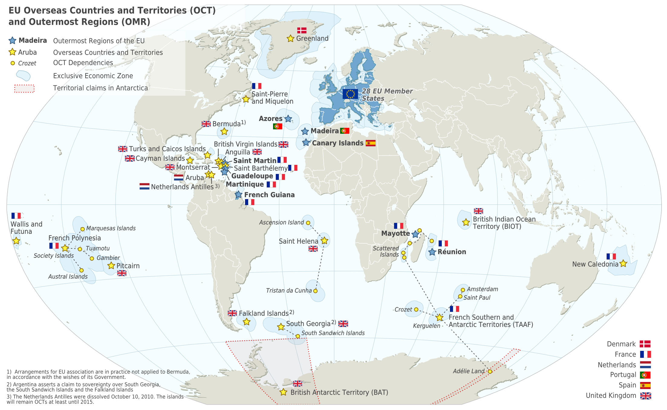
Deutsch: Karte der EU – Überseeische Länder und Hoheitsgebiete (OCT) und die Gebiete in äußerster Randlage (OMR). Diese Karte zeigt den räumlichen Geltungsbereich der Verträge der EU gemäß Artikel 52 des Vertrags über die Europäische Union und Artikel 355 des Vertrags über die Arbeitsweise der Europäischen Union.
Français : Carte de l’Union Européenne, en particulier les Pays et territoires d’outre-mer et les Régions ultrapériphériques. Cette carte montre la portée d’action territoriale des Traités de l’UE comme spécifié par l’Article 52 du Traité sur l’Union Européenne et l’Article 355 du Traité sur le Fonctionnement de l’Union Européenne.
English: Map of the EU – Overseas Countries and Territories (OCT) and Outermost Regions (OMR). This map shows the territorial scope of the Treaties of the EU as specified by Article 52 of the Treaty on European Union and Article 355 of the Treaty on the Functioning of the European Union. |
| Datum | |
| Quelle | Natural Earth 1:50m (http://www.naturalearthdata.com) |
| Urheber | Alexrk2 |
| Andere Versionen |
|
![[ar] Arabic version \ النسخة العربية](http://commons.wikimedia.org/wiki/File:Map-Europe-Outermost-regions-ar.PNG)
![[de] German version / deutsche Version](http://commons.wikimedia.org/wiki/File:Map-Europe-Outermost-regions-de.png)
![[fr] French version / version français](http://commons.wikimedia.org/wiki/File:Map-Europe-Outermost-regions-fr.png)


|
Diese Karte wurde in der Kartenwerkstatt erstellt oder verbessert. Auch du kannst dort Karten vorschlagen, die zu erstellen, verändern oder übersetzen sind.
|
Diese PNG-Rastergrafik wurde mit Inkscape erstellt .
Lizenz
Ich, der Urheber dieses Werkes, veröffentliche es unter der folgenden Lizenz:
Diese Datei ist unter der Creative-Commons-Lizenz „Namensnennung – Weitergabe unter gleichen Bedingungen 3.0 nicht portiert“ lizenziert.
- Dieses Werk darf von dir
- verbreitet werden – vervielfältigt, verbreitet und öffentlich zugänglich gemacht werden
- neu zusammengestellt werden – abgewandelt und bearbeitet werden
- Zu den folgenden Bedingungen:
- Namensnennung – Du musst angemessene Urheber- und Rechteangaben machen, einen Link zur Lizenz beifügen und angeben, ob Änderungen vorgenommen wurden. Diese Angaben dürfen in jeder angemessenen Art und Weise gemacht werden, allerdings nicht so, dass der Eindruck entsteht, der Lizenzgeber unterstütze gerade dich oder deine Nutzung besonders.
- Weitergabe unter gleichen Bedingungen – Wenn du das Material wiedermischst, transformierst oder darauf aufbaust, musst du deine Beiträge unter der gleichen oder einer kompatiblen Lizenz wie das Original verbreiten.
Dateiversionen
Klicke auf einen Zeitpunkt, um diese Version zu laden.
| Version vom | Vorschaubild | Maße | Benutzer | Kommentar | |
|---|---|---|---|---|---|
| aktuell | 08:14, 18. Feb. 2024 | | 2.206 × 1.358 (1.003 KB) | Sqrt of 2 | Reverted to version as of 18:05, 12 June 2023 (UTC) |
| 18:08, 15. Jan. 2024 |  | 2.206 × 1.358 (954 KB) | Multituberculata | Reverted to version as of 08:53, 31 May 2023 (UTC) | |
| 20:05, 12. Jun. 2023 |  | 2.206 × 1.358 (1.003 KB) | DecafPotato | Reverted to version as of 14:48, 27 February 2019 (UTC) – The image includes UK territories, and was made prior to Brexit; please keep the UK in the map as part of the European Union for this reason | |
| 10:53, 31. Mai 2023 |  | 2.206 × 1.358 (954 KB) | Iktsokh | Note | |
| 22:01, 21. Mai 2023 |  | 2.206 × 1.358 (951 KB) | Iktsokh | Correction | |
| 11:56, 18. Mai 2023 |  | 2.206 × 1.358 (950 KB) | Iktsokh | Updated | |
| 16:48, 27. Feb. 2019 |  | 2.206 × 1.358 (1.003 KB) | Radom1967 | Reverted to version as of 17:02, 22 March 2018 (UTC). No need | |
| 14:13, 25. Feb. 2019 |  | 2.206 × 1.358 (999 KB) | Odemirense | Countries with overseas regions in dark blue | |
| 19:02, 22. Mär. 2018 |  | 2.206 × 1.358 (1.003 KB) | Maphobbyist | South Sudan border | |
| 20:24, 1. Jan. 2014 |  | 2.206 × 1.358 (1 MB) | Alexrk2 | From 1 January 2014, the status of Mayotte will be that of an outermost region (COUNCIL DIRECTIVE 2013/61/EU of 17 December 2013) |
Dateiverwendung
Keine Seiten verwenden diese Datei.
Globale Dateiverwendung
Die nachfolgenden anderen Wikis verwenden diese Datei:
- Verwendung auf an.wikipedia.org
- Verwendung auf ar.wikipedia.org
- Verwendung auf ast.wikipedia.org
- Verwendung auf azb.wikipedia.org
- Verwendung auf bn.wikipedia.org
- Verwendung auf ca.wikipedia.org
- Verwendung auf cs.wikipedia.org
- Verwendung auf en.wikipedia.org
- Aruba
- Canary Islands
- Greenland
- Guadeloupe
- Martinique
- Mayotte
- Madeira
- Netherlands Antilles
- Réunion
- Overseas departments and regions of France
- Decolonisation of Africa
- History of colonialism
- Sint Maarten
- French Guiana
- User:Kazkaskazkasako/Books/All
- Caribbean Netherlands
- User:Tom29739/The EU
- User:Abyssal/bla
- User:Falcaorib
- List of colonies
- Verwendung auf en.wikiquote.org
- Verwendung auf en.wikivoyage.org
- Verwendung auf es.wikipedia.org
- Verwendung auf fa.wikipedia.org
- Verwendung auf fi.wikipedia.org
- Verwendung auf gl.wikipedia.org
- Verwendung auf id.wikipedia.org
- Verwendung auf ilo.wikipedia.org
- Verwendung auf it.wikipedia.org
- Verwendung auf ka.wikipedia.org
- Verwendung auf mk.wikipedia.org
- Verwendung auf nds-nl.wikipedia.org
Weitere globale Verwendungen dieser Datei anschauen.