Benutzer Diskussion:Chumwa/Archiv/2017/2. Quartal
.png)
_6a.jpg|Image_license/heading}})
OePNVSystemeDeutschland.png
Guten Abend Maximilian!
An der o. g. Karte fällt mir auf, dass die Waben, mit denen du die S-Bahn-Systeme andeutest oft viel zu klein sind. Die Wabe um Hannover entspricht fast eher der Straßenbahn/U-Bahn, die im Süden bis nach Sarstedt fährt, als dem S-Bahn-Netz: Dis S-Bahn fährt im Westen bis nach Minden, im Nordwesten bis nach Nienburg, im Nordosten bis nach Celle, im Südosten bis nach Goslar und im Südwesten gar bis nach Paderborn.
http://www.s-bahn-hannover.de/s_hannover/view/fahrplan/liniennetz.shtml
Wenn du statt der Waben mikronisierte Darstellungen der Original Netze verwenden würdest, gäbe es nicht dieses Problem der angemessenen Signaturgröße. Und wo sich zwei odr drei Netze berühren oder überschneiden, könntest du mit verschiedenen Farben arbeiten.
Du hast doch für etliche S-Bahn-Systeme schon selber Karten gezeichnet, kannst aber auch anderswo zu findende Darstellungen ohne URV verwenden, wenn du sie auf ein Zehntel ihres Originalmaßstabs oder kleiner eindampfst.
Beste Grüße von --Ulamm (Diskussion) 21:15, 2. Apr. 2017 (CEST)
- Hallo Ulamm. Die von dir genannte Karte ist bewusst abstrahiert angelegt, bei der die Symbolgrößen nichts mit der Größe der Netze zu tun haben. Es soll lediglich die Zahl und Verteilung der ÖPNV-Systeme in Deutschland dargestellt werden. Falls Du aber eine Karte suchst, mit der du Größenvergleiche anstellen willst, kann ich dir alternativ diese oder diese Karte (nur S-Bahnen) anbieten. --Chumwa (Diskussion) 06:51, 3. Apr. 2017 (CEST)
Minor correction on İstanbul transit map
Eminönü-Alibeyköy Cep Otogarı railway is now planned as a heavy RT instead of tram. Erkinalp9035 (Diskussion) 16:28, 8. Apr. 2017 (CEST)
- Thanks for the hint! --Chumwa (Diskussion) 16:45, 14. Apr. 2017 (CEST)
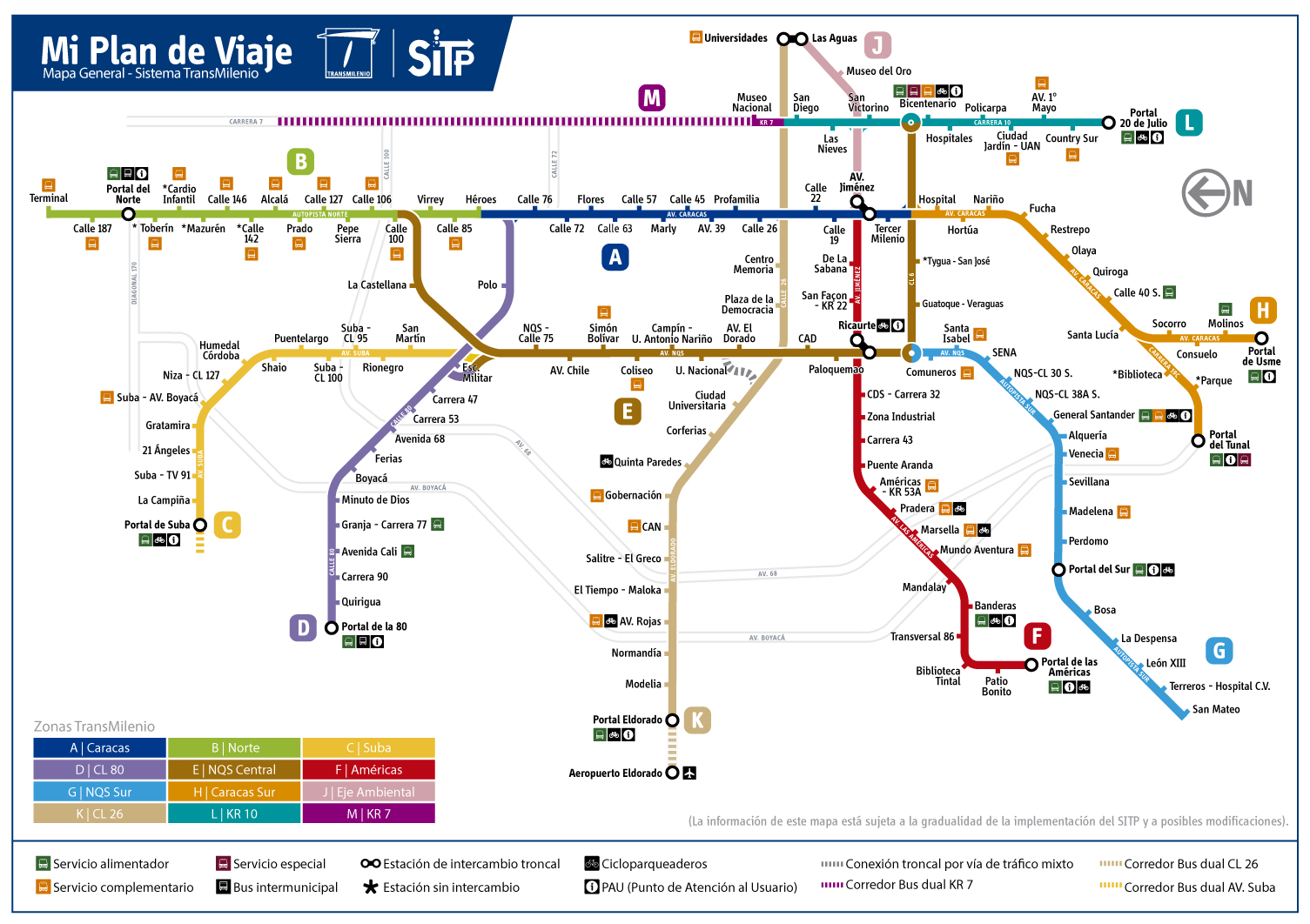
Trasmilenio Bogotá
Hello Chumwa, I was reading the Article of Bogotá and I saw the map you made of the Transmilenio system. I think it's fantastic work, but I also noticed that's from 2013. The system hasn't changed much, but I do think that the map could have a couple of minor changes. I would try to add some stuff but I don't know how you made the map, so I'll tell you what I would change, based on the official map of the system (http://www.sitp.gov.co/info/sitp/media/img75080.jpg):
- There are 5 new stations, 4 in the G line, to the west of Portal del Sur (Bosa, La Despensa, León XIII, Terreros - Hospital C.V., and San Mateo). There's one in the B line, all the way up, north of C.C. Santafé (which changed its name to Calle 187), it's called Terminal.
- Some stations are interconnected, as you can see in the official map: E-Ricaurte is connected to F-Ricaurte, J-Las Aguas is connected to K-Universidades, and F-Av. Jiménez is connected to A-Av. Jiménez.
I made a little sketch of the new stations: http://imgur.com/a/OIs9U
Thank you for your work! (nicht signierter Beitrag von 18:57, 14 April 2017 (Diskussion | Beiträge) Puertagustavo99)
- Thanks for all the information and the sketches! I've updated the map now, but I have some problems with the Transmilenio website: most of the pages don't load. So I wasn't able to check if all the data about the rutas alimentadores and the rutas corrientes on the map is up-to-date now too. If you can re-check this, this would be great!
- And just for interest: The tow stations of Ricaurte on E and F have a certain distance from each other. How the transfers are made there? Is there a closed corridoer between the two stops? --Chumwa (Diskussion) 07:09, 15 April 2017 (UTC)
Istanbul Metro.
Hi Chumwa. M9 Ataköy - İkitelli line is under construction.
http://www.metro.istanbul/media/84508/insaat_b-v3r4.jpg
--Lpxl (Diskussion) 17:23, 22 April 2017 (UTC)
Indonesia License Plates Maps
Hi Mr. Chumwa / Mr. Maximilian Dörrbecker, I'm username Alzena2nd from Indonesia. I want to tell you, because there has been a change in Indonesia License Plates Maps. I hope you can add a license plate number "KU" for North Kalimantan Province. Because, previously of North Kalimantan Province using the license plate "KT", the same as East Kalimantan Province. And then, license plate number "DS" changed become "PA" in Papua Province.
At below as a reference for you so you can easily change the Indonesia License Plates Maps:
Adding license plates number "KU"
- http://kaltara.prokal.co/read/news/10882-hari-ini-pelat-ku-diberlakukan.html
- http://kaltara.prokal.co/read/news/10885-banjir-selfie-ini-penampakan-mobil-pertama-di-kaltara-yang-pakai-pelat-ku.html
- http://www.tribunnews.com/regional/2017/02/07/kode-huruf-plat-kendaraan-kaltara-nantinya-bukan-kt-tapi-ku
License plates number changed from "DS" become "PA"
- http://www.wartaplus.com/perubahan-ds-menjadi-pa-harus-memberikan-dampak-positif-bagi-papua/
- http://kabarpapua.co/perubahan-plat-kode-kendaraan-di-papua-dari-ds-ke-pa-bernuansa-otonomi-khusus/
At last, I said thank you because you have been given the opportunity to report this changes to your profile even with a less fluent English. I apologize if I use English in your German discussion page. Alzena2nd (Diskussion) 11:02, 24. Apr. 2017 (CEST)
- I would be very proud if my English was only as good as yours. Thank you ver much for the information. The map is updated now. --Chumwa (Diskussion) 22:45, 28. Apr. 2017 (CEST)
New funicular line
Hi Chumwa,
A new funicular line between "Boğaziçi Üniversitesi" metro station and the coast of the bosphorus has been tendered. This new line will have 2 stations, the station on the bosphorus will be called "Aşiyan".
Unfortunately, I was only able to find a source written in Turkish.
- The maps are updated now. Thx! --Chumwa (Diskussion) 22:57, 28. Apr. 2017 (CEST)
.png)
The English version has two minor mistakes, when you translated from German to English, you forgot to change two countries. Mauritania and Iran have "NV", should be "NF" I was confused Gejyspa (Diskussion) 16:20, 25. Apr. 2017 (CEST)
- Please excuse my carelessness. This is corrected now. --Chumwa (Diskussion) 00:08, 29. Apr. 2017 (CEST)
Karte Offshore-Windkraftanlagen in der Deutschen_Bucht
Hi, hier mal wieder ein Update zu der Karte: Sandbank ist mittlerweile in Betrieb; Merkur (ehemals MEG Offshore) ist nun in Bau; Veja Mate ist in Teilbetrieb.
Belege siehe hier: https://de.wikipedia.org/wiki/Liste_der_Offshore-Windparks
Es gäbe auch zwei sinnvolle weitere Farben/Kategorien: Windparks für die die Bauentscheidung (endgültige Investitionsentscheidung) bereits getroffen wurde. Diese Parks werden sicher gebaut und sind derzeit in Bauvorbereitung. In der verlinkten Liste sind solche Parks lila hinterlegt. Das betrifft zur Zeit in der Nordsee die deutschen Parks Borkum Riffgrund 2, Hohe See und Trianel Borkum 2. Weiterhin gibt es noch die Parks, die bereits Netzkapazität zugewiesen bekommen haben, aber noch nicht in Bauvorbereitung sind. Diese Parks werden ziemlich sicher gebaut werden, aber ihre Finanzierung steht noch nicht endgültig. In diese Kategorie fallen zur Zeit die Parks Deutsche Bucht, Albatros (bzw. mit neuem Namen: Hohe See Extension), He Dreiht, Gode Wind 3, OWP West sowie Borkum Riffgrund 2.
Was die Positionen der verschiedenen Umspannstationen anbelangt, so ist hier ein relativ aktueller, offizieller (wenn auch eher schematischer) Stand zu finden: https://www.netzausbau.de/SharedDocs/Downloads/DE/2025/NEP/O-NEP-Karten.pdf?__blob=publicationFile
Gruss, Schluppo (Diskussion) 21:32, 20. Apr. 2017 (CEST)
- PS: Nun wurde auch Nordsee One in Teilbetrieb genommen. Gruss, Schluppo (Diskussion) 18:59, 27. Apr. 2017 (CEST)
- PPS: Nun wurden auch die Gemini-Parks in Betrieb genommen. Gruss, Schluppo (Diskussion) 17:07, 28. Apr. 2017 (CEST)
- Vielen Dank für die Infos und die Anregungen. Diese sind jetzt in die Karte aufgenommen (hoffentlich richtig...). --Chumwa (Diskussion) 00:03, 29. Apr. 2017 (CEST)
- Hi, sieht sehr gut aus. Einen Fehler habe ich jedoch gemacht: Bei der Kategorie "Netzkapazität zugewiesen" habe ich fälschlicherweise "Borkum Riffgrund 2" geschrieben. Das sollte "Borkum Riffgrund West II" heissen. Gruss, Schluppo (Diskussion) 23:07, 29. Apr. 2017 (CEST)
- PS: Die Umspannstationen BorWin epsilon und DolWin epsilon gibt es allerdings nun jeweils doppelt auf der Karte. Korrekt sind die Positionen, die grau ausgefüllt sind. Gruss, Schluppo (Diskussion) 23:14, 29. Apr. 2017 (CEST)
- Der erste Punkt geht klar. Zum PS: Wenn DolWin epsilon jetzt nach Westen rutscht, stellt sich die Frage an welche Transformerstation dann Nordsee 3 angebunden wird. Und: welche Farmen sollen dann an BorWin epsilon angeschlossen werden? --Chumwa (Diskussion) 08:29, 1. Mai 2017 (CEST)
- Nordsee 2 und 3 haben bisher noch keine Netzkapazität zugewiesen bekommen, sodass die Antwort hier noch offen ist; wenn der Betreiber der Parks (innogy) bei der nächsten Versteigerung im April 2018 für diese Parks Netzkapazität zugewiesen bekommt, dann wird das über DolWin 6 / DolWin zeta der Fall sein. Andernfalls gäbe es auch noch DolWin4 / DolWin delta, diese Plattform ist die letzte und dritte Plattform für Cluster 3, wird aber wohl erst nach 2025 fertiggestellt werden und die Kapazität erst in einigen Jahren versteigert werden. An BorWin epsilon wird nur der Park He Dreiht mit 900MW angeschlossen werden (hierzu werden He Dreiht und He Dreiht 2 zu einem einzigen Park mit 900MW zusammengelegt). Die aktuelle bereits feststehende Zuordnung der Parks zu Plattformen ist auch hier zu finden: https://de.wikipedia.org/wiki/Offshore-HGÜ-Systeme. Zu beachten ist bei dieser Liste, dass Global Tech 1 bei Fertigstellung von BorWin gamma dann über BorWin gamma und nicht mehr über BorWin beta angeschlossen werden wird und dann Deutsche Bucht und Albatros/Hohe See Extension die frei werdende Kapazität von BorWin beta erhalten (so, wie Du es schon in der Karte dargestellt hast). Zugegebenermassen ist das alle ein wenig verwirrend, aber so sind halt die Planungen der BNetzA :) Gruss, Schluppo (Diskussion) 01:54, 3. Mai 2017 (CEST)
- Habe jetzt versucht, diese Infos halbwegs nachvollziehbar einzubauen. Danke hierfür! --Chumwa (Diskussion) 09:11, 7. Mai 2017 (CEST)
- Nordsee 2 und 3 haben bisher noch keine Netzkapazität zugewiesen bekommen, sodass die Antwort hier noch offen ist; wenn der Betreiber der Parks (innogy) bei der nächsten Versteigerung im April 2018 für diese Parks Netzkapazität zugewiesen bekommt, dann wird das über DolWin 6 / DolWin zeta der Fall sein. Andernfalls gäbe es auch noch DolWin4 / DolWin delta, diese Plattform ist die letzte und dritte Plattform für Cluster 3, wird aber wohl erst nach 2025 fertiggestellt werden und die Kapazität erst in einigen Jahren versteigert werden. An BorWin epsilon wird nur der Park He Dreiht mit 900MW angeschlossen werden (hierzu werden He Dreiht und He Dreiht 2 zu einem einzigen Park mit 900MW zusammengelegt). Die aktuelle bereits feststehende Zuordnung der Parks zu Plattformen ist auch hier zu finden: https://de.wikipedia.org/wiki/Offshore-HGÜ-Systeme. Zu beachten ist bei dieser Liste, dass Global Tech 1 bei Fertigstellung von BorWin gamma dann über BorWin gamma und nicht mehr über BorWin beta angeschlossen werden wird und dann Deutsche Bucht und Albatros/Hohe See Extension die frei werdende Kapazität von BorWin beta erhalten (so, wie Du es schon in der Karte dargestellt hast). Zugegebenermassen ist das alle ein wenig verwirrend, aber so sind halt die Planungen der BNetzA :) Gruss, Schluppo (Diskussion) 01:54, 3. Mai 2017 (CEST)
- Der erste Punkt geht klar. Zum PS: Wenn DolWin epsilon jetzt nach Westen rutscht, stellt sich die Frage an welche Transformerstation dann Nordsee 3 angebunden wird. Und: welche Farmen sollen dann an BorWin epsilon angeschlossen werden? --Chumwa (Diskussion) 08:29, 1. Mai 2017 (CEST)
- PS: Die Umspannstationen BorWin epsilon und DolWin epsilon gibt es allerdings nun jeweils doppelt auf der Karte. Korrekt sind die Positionen, die grau ausgefüllt sind. Gruss, Schluppo (Diskussion) 23:14, 29. Apr. 2017 (CEST)
- Hi, sieht sehr gut aus. Einen Fehler habe ich jedoch gemacht: Bei der Kategorie "Netzkapazität zugewiesen" habe ich fälschlicherweise "Borkum Riffgrund 2" geschrieben. Das sollte "Borkum Riffgrund West II" heissen. Gruss, Schluppo (Diskussion) 23:07, 29. Apr. 2017 (CEST)
- Vielen Dank für die Infos und die Anregungen. Diese sind jetzt in die Karte aufgenommen (hoffentlich richtig...). --Chumwa (Diskussion) 00:03, 29. Apr. 2017 (CEST)
- PPS: Nun wurden auch die Gemini-Parks in Betrieb genommen. Gruss, Schluppo (Diskussion) 17:07, 28. Apr. 2017 (CEST)
Transmilenio
Hi, Chumwa! I'm the user that made the sketches about the new stations of the Transmilenio system in Bogotá. You said that you couldn't check the info about the rutas corrientes and the rutas alimentadoras so I searched a little bit.
Rutas Corrientes: -B1-F1: It's the same but it doesn't end in C.C. Santafé (which also in now named Calle 187), it now ends in Terminal -B5-G5: It's the same -C4-H4: It's the same -L7: No longer exists. I ran into some confusion regarding how to name this one. I suppose there used to be a route that went strictly from Portal 20 de julio to Museo Nacional. We don't have that anymore. Now, there is a route called L80 which goes from Portal 20 de julio to Fundación Santa Fe. The thing is, that's not a Transmilenio station, it's just a regular bus station. It goes beyond Museo Nacional (the only Carrera 7 station as of right now). I would suggest changing the name of the ruta corriente that goes from Portal 20 de julio to L80, and its route would extend to the very end of the M line, but with the striped lines, to signify it's not going through the exclusive lane, but through the mixed traffic lane. -K6-J6: The same
Rutas Alimentadoras: -Portal Norte: 2-6, 2-9, are gone. -Portal 20 de julio: 13-6 Juan Rey, 13-8 is gone, 13-9 Tihuaque, 13-10 Villa del Cerro, 13-12 Los Libertadores, 13-13 Resurreción -In Calle 187 (B), 2-12 is gone -In Bicentenario (L) -In Av. Cali (D), route 5-2 Avenida Carrera 91 -In Portal Eldorado (it's actually called Eldorado and not El Dorado, strange, I know) 16-1 is Tierra Grata
One little extra thing. I noticed another two stations that are missing. This is the official map http://www.sitp.gov.co/info/sitp/media/img75080.jpg , go to the L line, then to Bicentenario, and below it you'll find Tygua-San José, and Guatoque-Veraguas. They aren't present in your map, and you have that small corridor as a mixed traffic lane, which it's not, it's somehow part of the E line. Here's a sketch http://i.imgur.com/rP22IZN.png
And to answer your question about the connection between Ricaurte E and F, it's a long-ass undergroud tunnel, hahaha
I think that's it, after those changes the Transmilenio map is up-to-date. Thank you so much for your work, I think your map is even easier to understand than the official one.
- Thanks for all the information which now is included in the map. One point: you mentioned "Bicentenario (L)" above but there isn't any information about a change with it. Is ther missing something? --Chumwa (Diskussion) 09:30, 29. Apr. 2017 (CEST)
No, it's all right. The map looks awesome. I thank you for your work as a Bogotan - Puertagustavo99
Hello again, Chumwa. I found a couple of extra things to correct in the map. Today I got off the bus in a station (Niza - Calle 127) and I tried to look it up and it wasn't on the map! You had another name on it (Humedal Córdoba), that station is a couple hundred meters to the south.
I looked up every single station on the map so I knew no station was missing, and I found another small thing. In the D line, Granja and Carrera 77 are now one station: Granja - Carrera 77.
And the last thing, which I do believe is the last thing that's missing to make this map perfect, it's more striped lines, like the one in the M line. I made some sketches about where the official routes go on those striped lines. The C line and the K line have striped lines, too
- This info is included in the map too now. Thanks again! --Chumwa (Diskussion) 09:45, 7. Mai 2017 (CEST)
Wrong names of companies
Chumwa, could you be kind to correct the following names on this maps (commons:File:Railway map of Croatia and Bosnia and Herzegovina.png and commons:File:Railway map of South East Europe.png), according to original names in original languages:
- Hrvatske Željeznice -> Hrvatske željeznice (see w:hr:Hrvatske željeznice)
- Slovenske Železnice -> Slovenske železnice (see w:sl:Slovenske železnice)
- Makedonski Železnici -> Makedonski železnici (see w:mk:Македонски железници).
If it's problem, I can do it. Thanks.
By the way, great job with these (and the others, too) maps.--MaGa (Diskussion) 09:34, 14. Mai 2017 (CEST)
- I've changed this in the main map now (also for Български държавни железници, Железная дорога Молдовы, Приднестровская железная дорога and Українська залізниця), so that with the next update of the maps it will be included. --Chumwa (Diskussion) 09:33, 17. Mai 2017 (CEST)
- OK, thanks again. Keep up your good work.--MaGa (Diskussion) 17:30, 17. Mai 2017 (CEST)
Eisenbahnkarten
Hallo,
ich bin beeindruckt von deiner Eisenbahnkarte von Südost-Europe. Ich versuche schon seit langem aus OpenStreetMap gute Streckendaten zu gewinnen, aber es gibt leider mehrere Probleme. Einerseits bestehen die Strecken dort aus vielen Einzelstücken, während man für die Verarbeitung besser eine durchgängige Linie pro Strecke hat. Ich habe bisher keine zufriedenstellende Software gefunden, um GeoJSON-Linien automatisch zu verbinden (nicht zu FeatureCollections, sondern zu durchgängigen Linien).
Außerhalb von Westeuropa fehlen die meisten Bahnstreckenrelationen, sodass man von Hand Strecken zuordnen muss – von den Kursbuchnummer ganz zu schweigen. In den USA oder Russland z.B. hat man außerdem noch große Probleme mit "Müll", also Anschlussgleisen und anderen Stummeln, die man sich beim Export mit herausholt. Also erstelle und verbessere ich seit 2 Jahren bei OSM Eisenbahn-Relationen, aber die Welt ist so groß, dass man nie auch nur annähernd fertig wird.
Deine Karte ist also das absolute Non-Plus-Ultra für mich. Da schon ich einige Zeit auf der Suche nach solchen Daten bin – wärst du so nett, mir die reinen Vektoren der Bahnstrecken (ohne Hintergrund) an daqin AT outlook.de zu schicken?
Viele Grüße, --Railway Maps (Diskussion) 19:07, 18. Mai 2017 (CEST)
Railway map of Romania

Thank you for the effort of mapping the railways of Europe. However, pushing your maps in Wikipedia in languages you don't seem to speak without regards to the specific context of how a map is used looks a lot like self promotion. I'm talking about the map at ro:CFR, which was illustrating the different lines of the network and not the main vs. secondary lines like your map. I would like to suggest that in the future you propose such changes in the talk pages, just to avoid being reverted. Thank you.
You might also want to try and move to svg maps, they look much nicer when compressed or extended for different screens.--Strainu (Diskussion) 08:13, 17. Mai 2017 (CEST)
- Thank you for your words. In fact, when inserting a map, I normally check if it fits with the context. In this case I haven't recognized this special context. But you are generally right, that when I insert one of my maps, hubris also has a certain share. The second, but at least equally important reason is to create visibility. I want to keep the maps as correct as possible and up-to-date. Since I have only limited information sources, it is therefore extremely important that as many people as possible can see the map to recognize and report any errors - and the Romanian Wikipedia is an important place for this for a railway map of Romania. --Chumwa (Diskussion) 09:01, 17. Mai 2017 (CEST)
- Here are a few observations coming from a specialized forum:
- the line to Giurgiu is a branch line, not in operation and not electrified
- south of Sibiu, the branch to Cisnadie is closed
- line 201 Podu Old-Râmnicu Vâlcea should be thin (branch line)
- Valea Vișeului-Sighet has traffic
- Siret, Putna, Leorda -Dorohoi do not have traffic
- Rodna Veche is not only for freight
- Bixad is no longer in service
- Pietroșița is not only for freight
- To Argeșel we only have freight trains.
- Hope you can fix these in the near future. If something else comes up, I'll let you know.--Strainu (Diskussion) 20:05, 22. Mai 2017 (CEST)
- Here are a few observations coming from a specialized forum:
This remark isn't related to Serbian, but to Romanian railways. You should correct data for some lines in Romania which had been operated by private operator Regiotrans, which withdrawn service on some of them in March 2015. This article lists such lines: [[1]] Alexzr88 (Diskussion) 14:14, 22. Mai 2017 (CEST)
I've integrated the remarks of both of you in the map and the new version is uploaded now. Thanks a lot for these! The RegioTrans routes with withdrawn services are marked now as freight only routes - but they surely also can be closed completely. Do you have any more information about this? --Chumwa (Diskussion) 20:50, 22. Mai 2017 (CEST)
- Alexandria-Zimnicea is now operated by CFR Călători. I haven't checked the other routes, but in order to find those still operated, you can google search "Departure-Arrival tren" (without quotes), for example Alexandria Zimnicea tren. Results from mersultrenurilorcfr.ro indicate also the operator.--Strainu (Diskussion) 08:57, 23. Mai 2017 (CEST)
Karte der Verkehrsverbünde und Tarifverbünde in Deutschland, Österreich und der Schweiz, Tippfehler
Hallo Chumwa!
Du hast im Abschnitt Bayern, den Wort Salzburger VV falsch geschrieben, da steht Salzburegr VV.
LG Mö1997 (Noch Fragen?!?!) 06:25, 25. Mai 2017 (CEST)
Danke für den Hinweis! Ist korrigiert. --Chumwa (Diskussion) 20:44, 27. Mai 2017 (CEST)
Strasbourg tram map
Hello, an info for you : Yesterday the stations Port du Rhin and Kehl Bahnhof of the D line opened. These two are new terminus (yes, not all trams go to Germany), Aristide Briand is now a normal station. --Lyon-St-Clair (Diskussion) 20:58, 29 April 2017 (UTC)
- Merci pour l'avis! Les plans sont actualisés maintenant. --Chumwa (Diskussion) 07:30, 1 May 2017 (UTC)
- Thanks! Can you just write the name of the stations Starcoop and Citadelle in grey ? These stations are build, except the shelters, but their opening are planned for an other year, when the new Citadelle neighbourhood will be built and inhabited. --Lyon-St-Clair (Diskussion) 08:41, 1 May 2017 (UTC)
- C'est fait maintenant. --Chumwa (Diskussion) 07:48, 27 May 2017 (UTC)
- Thanks! Can you just write the name of the stations Starcoop and Citadelle in grey ? These stations are build, except the shelters, but their opening are planned for an other year, when the new Citadelle neighbourhood will be built and inhabited. --Lyon-St-Clair (Diskussion) 08:41, 1 May 2017 (UTC)
Railway map of Serbia
Hello! As a rail fan I like your railway map of Serbia. But, it is not completely accurate. I would like to suggest you some edits:
- Rail Belgrade-Pančevo is electrified
- Following rails are freight only (without passenger traffic): Zrenjanin-Sečanj-Jaša Tomić, Vršac-Bela Crkva, Novi Sad-Bečej, Novi Sad-Orlovat, Kikinda-Mokrin, Čoka-Novi Kneževac, Subotica-Horgoš-Szeged, Kikinda-Timisoara, Horgoš-Kanjiža, Karavukovo-Bač, Gajdobra-Bačka Palanka, Lapovo-Svilajnac-Despotovac
- Following rails were removed few decades ago, so they should be erased from the map since they don't exist: Vršac-Gataia, Žednik-Čantavir, Odžaci-Sombor
Best regards, Alexzr Alexzr88 (Diskussion) 20:56, 28. Apr. 2017 (CEST)
- Many thanks for all the hints! The map is corrected now. --Chumwa (Diskussion) 22:28, 28. Apr. 2017 (CEST)
I have noticed one more correction: Niš-Dimitrovgrad rail is not electrified. From Dimitrovgrad to Sofia it is. Also, according to categorization of Serbian railways, rail Subotica-Bogojevo is declared as main rail, so Subotica-Sombor section should be marked like that, while Sombor-Vrbas is defined as local rail, so it should be marked as branch line. Alexzr88 (Diskussion) 12:19, 3. Mai 2017 (CEST)
- Thanks again! --Chumwa (Diskussion) 22:50, 3. Mai 2017 (CEST) Chumwa (Diskussion) 20:43, 22. Mai 2017 (CEST)
Looks like railway numbers you used in a map of Serbia are outdated. Here is a document from 2016, where you can find list of railways by their current number, as well as a map of rail network with numbers at page 65: http://www.srbrail.rs/tarifejavne/SPT%2006a%20PT%20DEO%20VII%20-%20Daljinar%20od%2001-01-2016_5.pdf Alexzr88 (Diskussion) 20:33, 5. Jun. 2017 (CEST)
Hallo Chumwa!
Die von dir angelegte Seite Münchner Straßenschilder wurde zum Löschen vorgeschlagen. Gemäß den Löschregeln wird über die Löschung nun bis zu sieben Tage diskutiert und danach entschieden.
Du bist herzlich eingeladen, dich an der Löschdiskussion zu beteiligen. Wenn du möchtest, dass der Artikel behalten wird, kannst du dort die Argumente, die für eine Löschung sprechen, entkräften, indem du dich beispielsweise zur enzyklopädischen Relevanz des Artikels äußerst. Du kannst auch während der Löschdiskussion Artikelverbesserungen vornehmen, die die Relevanz besser erkennen lassen und die Mindestqualität sichern.
Da bei Wikipedia jeder Löschanträge stellen darf, sind manche Löschanträge auch offensichtlich unbegründet; solche Anträge kannst du ignorieren.
Vielleicht fühlst du dich durch den Löschantrag vor den Kopf gestoßen, weil der Antragsteller die Arbeit, die du in den Artikel gesteckt hast, nicht würdigt. Sei tapfer und bleibe dennoch freundlich. Der andere meint es vermutlich auch gut.
Grüße, Xqbot (Diskussion) 05:51, 9. Jun. 2017 (CEST) (Diese Nachricht wurde automatisch durch einen Bot erstellt. Wenn du zukünftig von diesem Bot nicht mehr über Löschanträge informiert werden möchtest, trag dich hier ein.)
Der Abschnitt von Riad zum bereits genutzten Teil der North-South-Railway in Saudi-Arabien wurde eröffnet: [2].--Intl Railways (Diskussion) 19:12, 8. Jun. 2017 (CEST)
- Ist aktualisiert. Danke für den Hinweis! --Chumwa (Diskussion) 20:54, 8. Jun. 2017 (CEST)
- Vielen Dank. Bist du dir sicher, dass die Strecke tatsächlich bis Al Haditha eröffnet wurde? Dazu habe ich nichts gefunden, es hätte aber bestimmt eine Meldung gegeben, wenn die Grenze zu Jordanien erreicht worden wäre.--Intl Railways (Diskussion) 21:12, 13. Jun. 2017 (CEST)
- Dass die Strecke bereits in Betrieb ist, glaube ich nicht, Testbetrieb besteht darauf aber wohl bereits. Die Gleise liegen auf alle Fälle bereits bis ganz kurz vor die jordanische Grenze, was auf der Googleerde leicht nachzuvollziehen ist. Das Projektstadium hat der Abschnitt bis Al Qurayyat aber auf alle Fälle bereits hinter sich. --Chumwa (Diskussion) 22:13, 13. Jun. 2017 (CEST)
- Vielen Dank. Bist du dir sicher, dass die Strecke tatsächlich bis Al Haditha eröffnet wurde? Dazu habe ich nichts gefunden, es hätte aber bestimmt eine Meldung gegeben, wenn die Grenze zu Jordanien erreicht worden wäre.--Intl Railways (Diskussion) 21:12, 13. Jun. 2017 (CEST)
Hier hat sich (schon wieder) einiges geändert:
- DolWin beta ist nun in Betrieb: http://www.offshorewind.biz/2017/06/15/abb-hands-over-dolwin2-offshore-wind-transmission-link-to-tennet/
- Die Parks Gode Wind 1 und 2 sind nun vollständig in Betrieb.
- Veja Mate ist nun (vorzeitig) vollständig in Betrieb: http://www.offshorewind.biz/2017/05/31/veja-mate-all-done-four-months-early/
- Hohe See extension (ehemals Albatros) wird sicher gebaut werden und ist nun also in Bauvorbereitung: http://www.offshorewind.biz/2017/05/09/enbw-greenlights-albatros-offshore-wind-farm-project/
- Noch eine kleine Korrektur zu den Änderungen von vor etwa einem Monat: Borkum Riffgrund II hat den Status "in Bauvorbereitung"; Borkum Riffgrund West II hat den Status "Netzkapazität zugewiesen".
Danke für die übersichtliche Karte und die schnellen Updates. Gruss, Schluppo (Diskussion) 19:16, 15. Jun. 2017 (CEST)
- Danke für die Hinweise! Die Aktualisierungen sind jetzt eingearbeitet. --Chumwa (Diskussion) 22:13, 21. Jun. 2017 (CEST)
Hello about Jiujiang metro
https://commons.wikimedia.org/wiki/File:%C3%96PNV-Systeme_in_China.png?uselang=zh Jiujiang Metro no building~--Qa003qa003 (Diskussion) 08:49, 21. Jun. 2017 (CEST)
- It's deleted now. --Chumwa (Diskussion) 22:50, 21. Jun. 2017 (CEST)
{{autotranslate|File:U-Bahn Bau an der Wandsbeker Marktstrasse (1961) 6a.jpg|Image license/heading}}
{{autotranslate|File:U-Bahn Bau an der Wandsbeker Marktstrasse (1961) 6a.jpg|Image license}}
Yours sincerely, Magog the Ogre (talk) (contribs) 04:11, 21 June 2017 (UTC)
Hamburger U-Bahn Karten
Moin, nochmals großes Lob an deine super tollen Karten! Mir ist bei den Hamburger U-Bahn Karten eine Kleinigkeit aufgefallen, die ich dir gerne nennen möchte (und du kannst entscheiden ob du es für nötig hältst sie zu korrigieren ;) ).
File:Hamburger Hochbahn - Plan der Linie U1.png, File:Hamburger Hochbahn - Plan der Linie U2.png, File:Hamburger Hochbahn - Plan der Linie U3.png zeigen im Hintergrund die U4 noch "in Bau" an. Sie ist aber (bis auf das letzte Stück) fertig gebaut und in Betrieb (vgl. File:Hamburger Hochbahn - Plan der Linie U4.png) Aus Einfachkeitsgründen würde ich sie auf den 3 genannten Karten bereits bis zu den Elbbrücken als "fertig"/duchgezogen einzeichnen (dann musst du in einem Jahr nicht wieder ran) außerdem liegen da eh schon Gleise. Sie ist also nur noch nicht eröffnet (Herbst 2018 ist momentan geplant). Grüße --ℱℒ𝒪ℛℐ𝒜𝒩 (Diskussion) 17:59, 12. Jun. 2017 (CEST)
- Danke für den Hinweis! Ich habe die Verlängerung bis zu den Elbbrücken jetzt dennoch erstmal gestrichelt eingezeichnet. Will ja schließlich nicht, dass mir die Arbeit ausgeht... ;-) --Chumwa (Diskussion) 22:36, 21. Jun. 2017 (CEST)
- haha sehr schön :D. Besten Dank für die Anstrengung. Ich sag dir spätestens bescheid wenn die Strecke eröffnet wurde ;) --ℱℒ𝒪ℛℐ𝒜𝒩 (Diskussion) 00:00, 22. Jun. 2017 (CEST)
- Archivierung dieses Abschnittes wurde gewünscht von: --ℱℒ𝒪ℛℐ𝒜𝒩 (Diskussion) 00:00, 22. Jun. 2017 (CEST)
About the Railway map of Moldova.png
Gute Abend Chumwa. Please see your Railway map of Moldova [3]: I collaborate with you, drawing the differences between the operators (some sections have two operators) and the electrified section at east of Tiraspol. Legend: I wrote "operation", not "opeartion". Danke sehr, --Julieta39 (Diskussion) 20:56, 19. Jun. 2017 (CEST)
![[3]](https://commons.wikimedia.org/wiki/File:Railway_map_of_Moldova.png)
- Thanks for the help. But I think the map was overcomplicated with all the colours and double lines just to show that the two operators operate in their proper part of the country. So I have simplified it now again a little bit. --Chumwa (Diskussion) 22:39, 22. Jun. 2017 (CEST)
Chaco-Krieg.png
Hallo Chumwa, hasst Du noch die Datei Chaco-Krieg.png im Entwicklungszustand? Natürlich ließe sich auch in der (veröffentlichten) PNG dies korrigieren. Ich würde das "Statsgebiet Paraguays nach dem Krieg" gerne mit zwei "a" lesen. Danke -- WikiMax - 08:35, 13. Jun. 2017 (CEST)
- Ja, ist noch da - und ist auch mittlerweile korrigiert. Danke für den Hinweis! --Chumwa (Diskussion) 22:44, 21. Jun. 2017 (CEST)
- Ich danke für deine Arbeit. -- WikiMax - 17:20, 29. Jun. 2017 (CEST)
Electrically-operated public transport in Zhejiang, China
On your map File:ÖPNV-Systeme in China.png:
- The name of the city "Zhejiang" is actually the name of the province, hence it might be better to remove that point. What's more, the city of Hangzhou is constructing its suburbs railway system, while the city of Ningbo just opened a suburbs railway service to Yuyao, but they are not marked on your map. —Siyuwj (Diskussion) 18:37, 29. Jun. 2017 (CEST)
- What's more, the city of Baotou has an operational suburbs railway service, while the city of Ordos is constructing a suburbs railway line, not a metro system. The city of Taiyuan is also constructing its suburbs railway lines to Jinzhong. —Siyuwj (Diskussion) 18:40, 29. Jun. 2017 (CEST)
- Even more, Shijiazhuang Metro just begins operation in June 26, 2017. Haikou is not constructing a subway system. The system in Macao is a light rail system, while the system constructing in Nantong is a metro system, not light rail. I don't know how to classify the system in Wuhu, as it is a monorail system with small rolling stocks. Also, to be more native, the Chinese for "in operation" should be replaced with "營運中" (traditional Chinese) or "运营中" (simplified Chinese). —Siyuwj (Diskussion) 18:56, 29. Jun. 2017 (CEST)
Thanks for all the hints! I will work them into the map in about two weeks, as soon as I'm back in Munich. --Chumwa (Diskussion) 18:50, 29. Jun. 2017 (CEST)
- The corrected version is uploaded now. --Chumwa (Diskussion) 23:19, 9. Jul. 2017 (CEST)