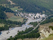
Ristolas
| Ristolas | ||
|---|---|---|

|
||
| Staat | Frankreich | |
| Region | Provence-Alpes-Côte d’Azur | |
| Département | Hautes-Alpes | |
| Arrondissement | Briançon | |
| Gemeinde | Abriès-Ristolas | |
| Koordinaten | 44° 46′ N, 6° 57′ O | |
| Postleitzahl | 05460 | |
| Ehemaliger INSEE-Code | 05120 | |
| Eingemeindung | 1. Januar 2019 | |
| Status | Commune déléguée | |
 Turm der Kirche Saint-Marcellin | ||
Ristolas ist eine Ortschaft und eine ehemalige französische Gemeinde mit 97 Einwohnern (Stand 1. Januar 2021) im Département Hautes-Alpes in der Region Provence-Alpes-Côte d’Azur. Sie gehörte zum Arrondissement Briançon und zum Kanton Guillestre.
Mit Wirkung vom 1. Januar 2019 wurden die ehemaligen Gemeinden Abriès und Ristolas zur Commune nouvelle Abriès-Ristolas zusammengeschlossen und haben in der neuen Gemeinde den Status einer Commune déléguée. Der Verwaltungssitz befindet sich im Ort Abriès.[1]
Geografie
[Bearbeiten | Quelltext bearbeiten]
Ristolas ist die östlichste Ortschaft des Départements Hautes-Alpes. Sie liegt im Tal des Guil, etwa 30 Kilometer südöstlich von Briançon. Die östliche Grenze liegt auf dem Alpenhauptkamm, der hier die Staatsgrenze zu Italien bildet. Das ehemalige Gemeindegebiet gehört zum Regionalen Naturpark Queyras.
Bevölkerungsentwicklung
[Bearbeiten | Quelltext bearbeiten]| Jahr | 1962 | 1968 | 1975 | 1982 | 1990 | 1999 | 2007 | 2016 |
| Einwohner | 49 | 350 | 68 | 52 | 72 | 70 | 93 | 80 |
| Quellen: Cassini und INSEE | ||||||||
