| [2]
|
Name[3]
|
Bild
|
Eintragsdatum
|
Lage
|
Ort
|
Beschreibung
|
| 1
|
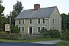
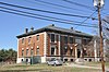
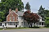
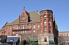
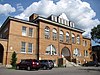
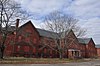
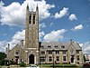
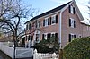
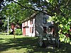
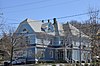
John Adams School
|
 John Adams School John Adams School
|
5. Dez. 1985
ID-Nr. 85003068
|
16 Church St.
42° 13′ 46,9″ N, 70° 56′ 46″ W42.2297-70.9461
| Weymouth |
|
| 2
|
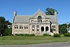
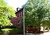
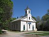
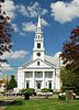
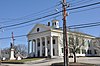
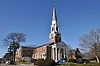
All Souls Church
|
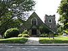 All Souls Church All Souls Church
|
7. Juli 2015
ID-Nr. 15000389
|
196 Elm St.
42° 13′ 23,2″ N, 71° 0′ 2,2″ W42.2231-71.0006
| Braintree |
|
| 3
|
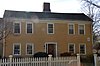
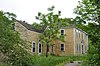
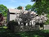
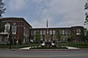
Ames Schoolhouse
|
 Ames Schoolhouse Ames Schoolhouse
|
31. März 1983
ID-Nr. 83004284
|
450 Washington St.
42° 14′ 43,1″ N, 71° 10′ 28,9″ W42.2453-71.1747
| Dedham |
|
| 4
|
Angle Tree Stone
|
 Angle Tree Stone Angle Tree Stone
|
1. Jan. 1976
ID-Nr. 76000228
|
41° 59′ 6″ N, 71° 21′ 54″ W41.985-71.365
| Plainville |
|
| 5
|
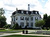
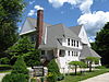
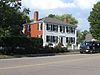
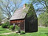
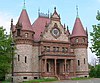
Jonathan Belcher House
|
 Jonathan Belcher House Jonathan Belcher House
|
30. Apr. 1976
ID-Nr. 76000291
|
360 N. Main St.
42° 10′ 9,1″ N, 71° 2′ 46″ W42.1692-71.0461
| Randolph |
|
| 6
|
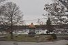
Blue Hills Reservation Parkways
|
 Blue Hills Reservation Parkways Blue Hills Reservation Parkways
|
11. Aug. 2003
ID-Nr. 03000746
|
42° 13′ 34″ N, 71° 4′ 19,9″ W42.2261-71.0722
| Braintree und Canton |
|
| 7
|
Borderland Historic District
|
 Borderland Historic District Borderland Historic District
|
16. Juni 1997
ID-Nr. 97000497
|
Massapoag Street
42° 4′ 1,6″ N, 71° 9′ 24,1″ W42.0671-71.1567
| Sharon |
Flächengleich mit dem Borderland State Park, erstreckt sich bis nach Easton im Bristol County.
|
| 8
|
Seth Boyden House
|
 Seth Boyden House Seth Boyden House
|
10. Nov. 1983
ID-Nr. 83004092
|
135 Oak St.
42° 4′ 22,1″ N, 71° 13′ 5,2″ W42.0728-71.2181
| Foxborough |
|
| 9
|
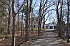
Brookwood Farm
|
 Brookwood Farm Brookwood Farm
|
25. Sep. 1980
ID-Nr. 80000655
|
Blue Hill River Rd.
42° 12′ 33,8″ N, 71° 6′ 41″ W42.2094-71.1114
| Canton |
Erstreckt sich bis nach Milton
|
| 10
|
Canton Corner Historic District
|
 Canton Corner Historic District Canton Corner Historic District
|
9. Sep. 2009
ID-Nr. 09000697
|
42° 10′ 25,7″ N, 71° 8′ 10″ W42.1738-71.1361
| Canton |
|
| 11
|
Canton Viaduct
|
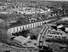 Canton Viaduct Canton Viaduct
|
20. Sep. 1984
ID-Nr. 84002870
|
Kreuzung von Neponset St. und Walpole St.
42° 9′ 32″ N, 71° 9′ 14″ W42.1589-71.1539
| Canton |
|
| 12
|
Ezra Carpenter House
|
 Ezra Carpenter House Ezra Carpenter House
|
3. Jan. 1985
ID-Nr. 85000029
|
168 South St.
42° 3′ 6,8″ N, 71° 15′ 16,9″ W42.0519-71.2547
| Foxborough |
|
| 13
|
Otis Cary House
|
 Otis Cary House Otis Cary House
|
13. März 1986
ID-Nr. 86000379
|
242 South St.
42° 2′ 42″ N, 71° 15′ 36″ W42.045-71.26
| Foxborough |
|
| 14
|
Benjamin Caryl House
|
 Benjamin Caryl House Benjamin Caryl House
|
2. Juni 2000
ID-Nr. 00000569
|
107 Dedham St.
42° 14′ 53,2″ N, 71° 16′ 17″ W42.2481-71.2714
| Dover |
|
| 15
|
Central Square Historic District
|
 Central Square Historic District Central Square Historic District
|
13. Feb. 1992
ID-Nr. 92000040
|
42° 13′ 0,1″ N, 70° 56′ 12,1″ W42.2167-70.9367
| Weymouth |
|
| 16
|
Lucius Clapp Memorial
|
 Lucius Clapp Memorial Lucius Clapp Memorial
|
18. Aug. 1992
ID-Nr. 92000998
|
6 Park St.
42° 7′ 27,1″ N, 71° 6′ 5″ W42.1242-71.1014
| Stoughton |
|
| 17
|
Cobb’s Tavern
|
 Cobb’s Tavern Cobb’s Tavern
|
7. Aug. 1974
ID-Nr. 74000383
|
41 Bay Rd.
42° 8′ 13,9″ N, 71° 8′ 57,8″ W42.1372-71.1494
| Sharon |
|
| 18
|
Cohasset Central Cemetery
|
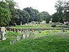 Cohasset Central Cemetery Cohasset Central Cemetery
|
27. Dez. 2002
ID-Nr. 02001612
|
N. Main St. und Joy Place
42° 14′ 44,9″ N, 70° 48′ 25,9″ W42.2458-70.8072
| Cohasset |
|
| 19
|
Cohasset Common Historic District
|
 Cohasset Common Historic District Cohasset Common Historic District
|
28. Feb. 1996
ID-Nr. 96000058
|
42° 14′ 31,9″ N, 70° 48′ 10,1″ W42.2422-70.8028
| Cohasset |
|
| 20
|
Colburn School-High Street Historic District
|
 Colburn School-High Street Historic District Colburn School-High Street Historic District
|
9. Juni 2000
ID-Nr. 00000641
|
369-649, 390-680 High St.
42° 13′ 48″ N, 71° 13′ 17″ W42.23-71.2214
| Westwood |
|
| 21
|
Fred Holland Day House
|
 Fred Holland Day House Fred Holland Day House
|
18. Apr. 1977
ID-Nr. 77000191
|
93 Day St.
42° 11′ 35,2″ N, 71° 12′ 13″ W42.1931-71.2036
| Norwood |
|
| 22
|
Dean Junior College Historic District
|
 Dean Junior College Historic District Dean Junior College Historic District
|
23. Apr. 1975
ID-Nr. 75000285
|
Campus des Dean College
42° 5′ 7,1″ N, 71° 23′ 56″ W42.0853-71.3989
| Franklin |
|
| 23
|
Dedham Village Historic District
|
 Dedham Village Historic District Dedham Village Historic District
|
6. Sep. 2006
ID-Nr. 06000785
|
42° 14′ 53,9″ N, 71° 10′ 49,1″ W42.2483-71.1803
| Dedham |
|
| 24
|
Dwight-Derby House
|
 Dwight-Derby House Dwight-Derby House
|
17. Jan. 2002
ID-Nr. 01001465
|
7 Frairy St.
42° 11′ 16,1″ N, 71° 18′ 29,9″ W42.1878-71.3083
| Medfield |
|
| 25
|
Eaton-Moulton Mill
|
 Eaton-Moulton Mill Eaton-Moulton Mill
|
16. Mai 1976
ID-Nr. 76000294
|
35 Walnut St.
42° 19′ 32,2″ N, 71° 15′ 16,9″ W42.3256-71.2547
| Wellesley |
|
| 26
|
Echo Bridge
|
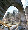 Echo Bridge Echo Bridge
|
9. Apr. 1980
ID-Nr. 80000638
|
Überspannt den Charles River
42° 18′ 52,9″ N, 71° 13′ 39″ W42.3147-71.2275
| Needham |
|
| 27
|
Ellice School
|
 Ellice School Ellice School
|
24. Sep. 2010
ID-Nr. 10000785
|
185 Pleasant St.
42° 8′ 44,2″ N, 71° 21′ 29,2″ W42.1456-71.3581
| Millis |
|
| 28
|
Elm Bank
|
 Elm Bank Elm Bank
|
10. Juli 1987
ID-Nr. 86003565
|
42° 16′ 34″ N, 71° 18′ 9″ W42.2761-71.3025
| Dover und Wellesley |
|
| 29
|
Elm Park and Isaac Sprague Memorial Tower
|
 Elm Park and Isaac Sprague Memorial Tower Elm Park and Isaac Sprague Memorial Tower
|
5. Juni 2007
ID-Nr. 07000511
|
305 Washington St.
42° 18′ 41,8″ N, 71° 16′ 30,7″ W42.3116-71.2752
| Wellesley |
|
| 30
|
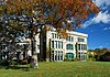
Endicott Estate
|
 Endicott Estate Endicott Estate
|
6. März 2002
ID-Nr. 02000128
|
656 East St.
42° 14′ 29″ N, 71° 9′ 47,9″ W42.2414-71.1633
| Dedham |
|
| 31
|
Evergreen Cemetery
|
|
4. Aug. 2021
ID-Nr. 02000128
|
8 Evergreen St.
42° 8′ 51″ N, 71° 25′ 25″ W42.1475-71.423611
| Medway |
|
| 32
|
Fairbanks House
|
 Fairbanks House Fairbanks House
weitere Bilder
|
15. Okt. 1966
ID-Nr. 66000367
|
Eastern Ave. und East St.
42° 14′ 35,2″ N, 71° 10′ 5,2″ W42.2431-71.1681
| Dedham |
|
| 33
|
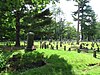
Fairview Cemetery
|
 Fairview Cemetery Fairview Cemetery
|
16. Sep. 2009
ID-Nr. 09000717
|
45 Fairview Ave., Boston
42° 14′ 45,2″ N, 71° 8′ 18,5″ W42.245897-71.138464
| Dedham |
Liegt zum größten Teil auf dem Stadtgebiet von Boston.
|
| 34
|
D.W. Field Park
|
 D.W. Field Park D.W. Field Park
|
24. Nov. 2000
ID-Nr. 00001341
|
42° 6′ 17″ N, 71° 2′ 47″ W42.104722-71.046389
| Avon |
Erstreckt sich bis nach Brockton.
|
| 35
|
First Baptist Church of Medfield
|
 First Baptist Church of Medfield First Baptist Church of Medfield
|
11. Sep. 2003
ID-Nr. 03000921
|
438 Main St.
42° 11′ 12,8″ N, 71° 18′ 15,1″ W42.1869-71.3042
| Medfield |
|
| 36
|
First Parish Unitarian Church
|
 First Parish Unitarian Church First Parish Unitarian Church
|
18. Apr. 1974
ID-Nr. 74000376
|
North St.
42° 11′ 13,9″ N, 71° 18′ 24,8″ W42.1872-71.3069
| Medfield |
|
| 37
|
Fisher School-High Street Historic District
|
 Fisher School-High Street Historic District Fisher School-High Street Historic District
|
30. Juni 2000
ID-Nr. 00000687
|
748-850 und 751-823 High St.
42° 13′ 23,9″ N, 71° 13′ 25″ W42.2233-71.2236
| Westwood |
|
| 38
|
Fogg Building
|
 Fogg Building Fogg Building
|
10. März 1983
ID-Nr. 83000594
|
100-110 Pleasant St. und 6-10 Columbian St.
42° 10′ 27,8″ N, 70° 57′ 6,8″ W42.1744-70.9519
| Weymouth |
|
| 39
|
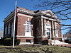
Fogg Library
|
 Fogg Library Fogg Library
|
11. Juni 1981
ID-Nr. 81000113
|
1 Columbian St.
42° 10′ 27,8″ N, 70° 57′ 4″ W42.1744-70.9511
| Weymouth |
|
| 40
|
Foxboro Grange Hall
|
 Foxboro Grange Hall Foxboro Grange Hall
|
21. Apr. 1983
ID-Nr. 83000595
|
11-15 Bird St.
42° 3′ 56,2″ N, 71° 15′ 2,2″ W42.0656-71.2506
| Foxborough |
|
| 41
|
Foxborough Pumping Station
|
 Foxborough Pumping Station Foxborough Pumping Station
|
6. Dez. 2005
ID-Nr. 05001362
|
25 Pumping Station Rd.
42° 4′ 40,1″ N, 71° 14′ 17,9″ W42.0778-71.2383
| Foxborough |
|
| 42
|
Foxborough State Hospital
|
 Foxborough State Hospital Foxborough State Hospital
|
19. Juli 1994
ID-Nr. 94000695
|
42° 4′ 41,2″ N, 71° 15′ 29,9″ W42.0781-71.2583
| Foxborough |
|
| 43
|
Franklin Common Historic District
|
 Franklin Common Historic District Franklin Common Historic District
|
31. März 2005
ID-Nr. 05000218
|
42° 5′ 19″ N, 71° 24′ 5″ W42.0886-71.4014
| Franklin |
|
| 44
|
Front Street Historic District
|
 Front Street Historic District Front Street Historic District
|
10. Jan. 2011
ID-Nr. 10001121
|
42° 12′ 38,9″ N, 70° 57′ 42,8″ W42.2108-70.9619
| Weymouth |
|
| 45
|
Fuller Brook Park
|
 Fuller Brook Park Fuller Brook Park
|
29. Mai 2013
ID-Nr. 11000307
|
Dover Rd.
42° 18′ 38,8″ N, 71° 16′ 26,4″ W42.310791-71.273988
| Wellesley |
|
| 46
|
Amos Fuller House
|
 Amos Fuller House Amos Fuller House
|
31. März 1983
ID-Nr. 83000596
|
220 Nehoiden St.
42° 17′ 7,1″ N, 71° 14′ 30,8″ W42.2853-71.2419
| Needham |
|
| 47
|
Robert Fuller House
|
 Robert Fuller House Robert Fuller House
|
8. Sep. 1987
ID-Nr. 87001476
|
3 Burrill Ln.
42° 17′ 37″ N, 71° 15′ 27″ W42.2936-71.2575
| Needham |
|
| 48
|
Gills Farm Archeological District
|
|
24. Okt. 1983
ID-Nr. 83004093
|
Adresse wird nicht veröffentlicht
| Randolph |
Ausgrabung aus der mittleren Archaischen Periode.
|
| 49
|
Government Island Historic District
|
 Government Island Historic District Government Island Historic District
|
12. Mai 1994
ID-Nr. 94000424
|
Border St.
42° 14′ 17,2″ N, 70° 47′ 21,1″ W42.2381-70.7892
| Cohasset |
|
| 50
|
Green Hill Site
|
 Green Hill Site Green Hill Site
|
25. Sep. 1980
ID-Nr. 80000651
|
Am Neponset River
| Canton |
Ausgrabung aus der mittleren und späten Archaischen Periode.
|
| 51
|
Emery Grover Building
|
 Emery Grover Building Emery Grover Building
|
20. Aug. 1987
ID-Nr. 87001393
|
1330 Highland Ave.
42° 16′ 59,2″ N, 71° 14′ 10″ W42.2831-71.2361
| Needham |
|
| 52
|
Josephine M. Hagerty House
|
 Josephine M. Hagerty House Josephine M. Hagerty House
|
4. Juni 1997
ID-Nr. 97000529
|
357 Atlantic Ave.
42° 15′ 31″ N, 70° 48′ 8,6″ W42.2586-70.8024
| Cohasset |
|
| 53
|
Holbrook Square Historic District
|
 Holbrook Square Historic District Holbrook Square Historic District
|
10. Mai 2006
ID-Nr. 06000359
|
42° 9′ 20,2″ N, 71° 0′ 34,9″ W42.1556-71.0097
| Holbrook |
|
| 54
|
Hunnewell Estates Historic District
|
 Hunnewell Estates Historic District Hunnewell Estates Historic District
|
14. Apr. 1988
ID-Nr. 88000438
|
Washington St. und Pond Rd.
42° 16′ 59,2″ N, 71° 18′ 40″ W42.2831-71.3111
| Wellesley |
|
| 55
|
Inness-Fitts House and Studio/Barn
|
 Inness-Fitts House and Studio/Barn Inness-Fitts House and Studio/Barn
|
15. März 2002
ID-Nr. 02000153
|
406 Main St.
42° 11′ 16,1″ N, 71° 18′ 6,8″ W42.1878-71.3019
| Medfield |
|
| 56
|
Intermediate Building
|
 Intermediate Building Intermediate Building
|
27. Aug. 1981
ID-Nr. 81000112
|
324 Washington St.
42° 18′ 38,2″ N, 71° 16′ 30″ W42.3106-71.275
| Wellesley |
|
| 57
|
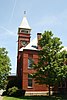
Jefferson School
|
 Jefferson School Jefferson School
|
12. Mai 1981
ID-Nr. 81000114
|
200 Middle St.
42° 13′ 0,1″ N, 70° 56′ 15″ W42.2167-70.9375
| Weymouth |
|
| 58
|
Kingsbury-Whitaker House
|
 Kingsbury-Whitaker House Kingsbury-Whitaker House
|
12. Juli 1990
ID-Nr. 90001080
|
53 Glendoon St.
42° 16′ 54,1″ N, 71° 14′ 25,1″ W42.2817-71.2403
| Needham |
|
| 59
|
Deacon Willard Lewis House
|
 Deacon Willard Lewis House Deacon Willard Lewis House
|
29. Okt. 1975
ID-Nr. 75000297
|
33 West St.
42° 8′ 42″ N, 71° 15′ 19,1″ W42.145-71.2553
| Walpole |
|
| 60
|
Joshua Lewis House
|
 Joshua Lewis House Joshua Lewis House
|
1. Apr. 1982
ID-Nr. 82002749
|
178 South St.
42° 15′ 51,1″ N, 71° 12′ 34,9″ W42.2642-71.2097
| Needham |
|
| 61
|
Caleb Lothrop House
|
 Caleb Lothrop House Caleb Lothrop House
|
3. Mai 1976
ID-Nr. 76000269
|
14 Summer St.
42° 14′ 11,8″ N, 70° 47′ 48,8″ W42.2366-70.7969
| Cohasset |
|
| 62
|
McIntosh Corner Historic District
|
 McIntosh Corner Historic District McIntosh Corner Historic District
|
5. Jan. 1989
ID-Nr. 88003127
|
42° 16′ 52″ N, 71° 15′ 16,9″ W42.2811-71.2547
| Needham |
|
| 63
|
Medfield State Hospital
|
 Medfield State Hospital Medfield State Hospital
|
21. Jan. 1994
ID-Nr. 93001481
|
45 Hospital Rd.
42° 12′ 47,9″ N, 71° 20′ 10″ W42.2133-71.3361
| Medfield |
|
| 64
|
Medway Village Historic District
|
 Medway Village Historic District Medway Village Historic District
|
17. Dez. 2008
ID-Nr. 08001191
|
42° 8′ 30,5″ N, 71° 23′ 48,1″ W42.1418-71.3967
| Medway |
|
| 65
|
Memorial Hall
|
 Memorial Hall Memorial Hall
|
21. Apr. 1983
ID-Nr. 83000597
|
22 South St.
42° 3′ 50″ N, 71° 15′ 2,2″ W42.0639-71.2506
| Foxborough |
|
| 66
|
Millis Center Historic District
|
 Millis Center Historic District Millis Center Historic District
weitere Bilder
|
14. Sep. 2007
ID-Nr. 07000944
|
42° 10′ 3″ N, 71° 21′ 36″ W42.1675-71.36
| Millis |
|
| 67
|
Davis Mills House
|
 Davis Mills House Davis Mills House
|
1. Apr. 1982
ID-Nr. 82004418
|
945 Central Ave.
42° 17′ 17,2″ N, 71° 15′ 6,8″ W42.2881-71.2519
| Needham |
|
| 68
|
Amos Morse House
|
 Amos Morse House Amos Morse House
|
9. Jan. 1986
ID-Nr. 86000027
|
77 North St.
42° 5′ 3,8″ N, 71° 15′ 29,2″ W42.0844-71.2581
| Foxborough |
|
| 69
|
Needham Street Bridge
|
 Needham Street Bridge Needham Street Bridge
|
4. Sep. 1986
ID-Nr. 86001852
|
Überspannt den Charles River
42° 18′ 23″ N, 71° 13′ 3″ W42.3064-71.2175
| Needham |
|
| 70
|
Needham Town Hall Historic District
|
 Needham Town Hall Historic District Needham Town Hall Historic District
|
15. Nov. 1990
ID-Nr. 90001756
|
Great Plain Ave.
42° 17′ 20″ N, 71° 14′ 26,2″ W42.2889-71.2406
| Needham |
|
| 71
|
Norfolk County Courthouse
|
 Norfolk County Courthouse Norfolk County Courthouse
|
28. Nov. 1972
ID-Nr. 72001312
|
650 High St.
42° 14′ 55″ N, 71° 10′ 36,1″ W42.2486-71.1767
| Dedham |
|
| 72
|
Norfolk Grange Hall
|
 Norfolk Grange Hall Norfolk Grange Hall
|
25. Mai 1989
ID-Nr. 89000438
|
28 Rockwood Rd.
42° 7′ 19,9″ N, 71° 19′ 58,1″ W42.1222-71.3328
| Norfolk |
|
| 73
|
North Bellingham Cemetery and Oak Hill Cemetery
|
 North Bellingham Cemetery and Oak Hill Cemetery North Bellingham Cemetery and Oak Hill Cemetery
|
25. Sep. 2012
ID-Nr. 12000819
|
Hartford Ave.
42° 7′ 1″ N, 71° 27′ 34,2″ W42.116943-71.459511
| Bellingham |
|
| 74
|
Norwood Memorial Municipal Building
|
 Norwood Memorial Municipal Building Norwood Memorial Municipal Building
|
10. Okt. 1996
ID-Nr. 96001086
|
566 Washington St.
42° 11′ 40,9″ N, 71° 12′ 2,2″ W42.1947-71.2006
| Norwood |
|
| 75
|
Oak Grove Farm
|
 Oak Grove Farm Oak Grove Farm
|
4. Mai 2011
ID-Nr. 11000247
|
410 Exchange St.
42° 10′ 52″ N, 71° 21′ 46,1″ W42.1811-71.3628
| Millis |
|
| 76
|
Old Barn
|
 Old Barn Old Barn
|
25. Sep. 1980
ID-Nr. 80000660
|
Blue Hill River Road
42° 12′ 24,8″ N, 71° 6′ 40″ W42.2069-71.1111
| Canton |
|
| 77
|
Old South Union Church
|
 Old South Union Church Old South Union Church
|
1. Apr. 1982
ID-Nr. 82004422
|
25 Columbian St.
42° 10′ 30″ N, 70° 57′ 6,1″ W42.175-70.9517
| Weymouth |
|
| 78
|
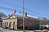
Original Congregational Church of Wrentham
|
 Original Congregational Church of Wrentham Original Congregational Church of Wrentham
|
22. Sep. 2014
ID-Nr. 14000694
|
1 East & 22 Dedham Sts.
42° 4′ 0,8″ N, 71° 19′ 38,6″ W42.0669-71.3274
| Wrentham |
|
| 79
|
John Partridge House
|
 John Partridge House John Partridge House
|
15. Okt. 1974
ID-Nr. 74000377
|
315 Exchange St.
42° 10′ 34″ N, 71° 21′ 38,2″ W42.1761-71.3606
| Millis |
|
| 80
|
Peak House
|
 Peak House Peak House
|
5. Sep. 1975
ID-Nr. 75000288
|
347 Main St.
42° 11′ 22,9″ N, 71° 17′ 49,9″ W42.1897-71.2972
| Medfield |
|
| 81
|
Plimpton-Winter House
|
 Plimpton-Winter House Plimpton-Winter House
|
5. Dez. 1985
ID-Nr. 85003071
|
127 South St.
42° 3′ 52,9″ N, 71° 19′ 50,2″ W42.0647-71.3306
| Wrentham |
|
| 82
|
Pond Street School
|
 Pond Street School Pond Street School
|
12. Feb. 2010
ID-Nr. 10000004
|
235 Pond St.
42° 9′ 45,4″ N, 70° 57′ 36″ W42.1626-70.96
| Weymouth |
|
| 83
|
Pondville Cemetery
|
 Pondville Cemetery Pondville Cemetery
|
15. Apr. 2014
ID-Nr. 14000158
|
Everett Street
42° 5′ 6,4″ N, 71° 17′ 42″ W42.0851-71.295
| Norfolk |
|
| 84
|
Ponkapoag Camp of Appalachian Mountain Club
|
 Ponkapoag Camp of Appalachian Mountain Club Ponkapoag Camp of Appalachian Mountain Club
|
25. Sep. 1980
ID-Nr. 80000657
|
42° 11′ 35,2″ N, 71° 5′ 13,9″ W42.1931-71.0872
| Randolph |
|
| 85
|
Pratt Historic Building
|
 Pratt Historic Building Pratt Historic Building
|
7. Sep. 2006
ID-Nr. 06000816
|
106 S. Main St.
42° 14′ 19,3″ N, 70° 47′ 58,9″ W42.2387-70.7997
| Cohasset |
|
| 86
|
Capt. Josiah Pratt House
|
 Capt. Josiah Pratt House Capt. Josiah Pratt House
|
21. Apr. 1983
ID-Nr. 83000598
|
141 East St.
42° 3′ 47,9″ N, 71° 12′ 2,9″ W42.0633-71.2008
| Foxborough |
|
| 87
|
Prospect Hill Cemetery
|
 Prospect Hill Cemetery Prospect Hill Cemetery
|
15. März 2006
ID-Nr. 06000129
|
Auburn Rd.
42° 9′ 59″ N, 71° 22′ 4,1″ W42.1664-71.3678
| Millis |
|
| 88
|
Rabbit Hill Historic District
|
 Rabbit Hill Historic District Rabbit Hill Historic District
|
1. Apr. 1988
ID-Nr. 88000224
|
42° 8′ 39,1″ N, 71° 26′ 2″ W42.1442-71.4339
| Medway |
|
| 89
|
Red Brick School
|
 Red Brick School Red Brick School
|
1. Jan. 1976
ID-Nr. 76000276
|
2 Lincoln St.
42° 5′ 34,1″ N, 71° 24′ 0″ W42.0928-71.4
| Franklin |
|
| 90
|
Redman Farm House
|
 Redman Farm House Redman Farm House
|
25. Sep. 1980
ID-Nr. 80000664
|
2173 Washington St.
42° 11′ 30,1″ N, 71° 7′ 2,6″ W42.1917-71.1174
| Canton |
Im Register unter falscher Adresse eingetragen.
|
| 91
|
Roberts School
|
 Roberts School Roberts School
|
30. Aug. 2007
ID-Nr. 07000860
|
320 Union St.
42° 9′ 18″ N, 71° 1′ 25″ W42.155-71.0236
| Holbrook |
|
| 92
|
Rockwood Road Historic District
|
|
10. Apr. 2017
ID-Nr. 100000850
|
42° 7′ 16,2″ N, 71° 19′ 49″ W42.121171-71.3302746
| Norfolk |
|
| 93
|
Roebuck Tavern
|
 Roebuck Tavern Roebuck Tavern
|
17. Mai 1984
ID-Nr. 84002878
|
21 Dedham St.
42° 4′ 3″ N, 71° 19′ 41,2″ W42.0675-71.3281
| Wrentham |
|
| 94
|
Sea Street Historic District
|
 Sea Street Historic District Sea Street Historic District
|
19. Aug. 2009
ID-Nr. 09000646
|
42° 14′ 35,2″ N, 70° 56′ 53,9″ W42.2431-70.9483
| Weymouth |
|
| 95
|
Sharon Historic District
|
 Sharon Historic District Sharon Historic District
|
22. Aug. 1975
ID-Nr. 75000296
|
42° 7′ 27,8″ N, 71° 10′ 45,1″ W42.1244-71.1792
| Sharon |
|
| 96
|
James Smith House
|
 James Smith House James Smith House
|
21. Aug. 1986
ID-Nr. 86001845
|
706 Great Plain Ave.
42° 16′ 49,1″ N, 71° 13′ 36,1″ W42.2803-71.2267
| Needham |
|
| 97
|
Stetson Hall
|
 Stetson Hall Stetson Hall
|
7. Dez. 2011
ID-Nr. 11000883
|
6 S. Main St.
42° 9′ 44,6″ N, 71° 2′ 29″ W42.1624-71.0414
| Randolph |
|
| 98
|
Stoneholm
|
 Stoneholm Stoneholm
|
2. Apr. 1980
ID-Nr. 80000648
|
188 Ames St.
42° 6′ 55,1″ N, 71° 9′ 56,9″ W42.1153-71.1658
| Sharon |
|
| 99
|
Stony Brook Reservation Parkways
|
 Stony Brook Reservation Parkways Stony Brook Reservation Parkways
|
3. Jan. 2006
ID-Nr. 05001509
|
42° 15′ 28,1″ N, 71° 8′ 31,9″ W42.2578-71.1422
| Dedham |
Erstreckt sich bis nach Boston.
|
| 100
|
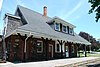
Stoughton Railroad Station
|
 Stoughton Railroad Station Stoughton Railroad Station
weitere Bilder
|
21. Jan. 1974
ID-Nr. 74000384
|
53 Wyman St.
42° 7′ 27,1″ N, 71° 5′ 57,8″ W42.1242-71.0994
| Stoughton |
|
| 101
|
Stoughtonham Furnace Site
|
 Stoughtonham Furnace Site Stoughtonham Furnace Site
|
16. Aug. 1984
ID-Nr. 84002881
|
42° 4′ 56,3″ N, 71° 12′ 43,9″ W42.0823-71.2122
| Sharon und Foxborough |
|
| 102
|
Sudbury Aqueduct Linear District
|
 Sudbury Aqueduct Linear District Sudbury Aqueduct Linear District
weitere Bilder
|
18. Jan. 1990
ID-Nr. 89002293
|
42° 17′ 33″ N, 71° 18′ 43,9″ W42.2925-71.3122
| Wellesley, Needham |
|
| 103
|
Sullivan’s Corner Historic District
|
 Sullivan’s Corner Historic District Sullivan’s Corner Historic District
|
15. Juni 2012
ID-Nr. 12000340
|
42° 7′ 13,6″ N, 71° 18′ 38,8″ W42.120437-71.310766
| Norfolk |
|
| 104
|
Thayer Public Library
|
 Thayer Public Library Thayer Public Library
|
21. Juli 1978
ID-Nr. 78000446
|
2 John F. Kennedy Memorial Dr.
42° 12′ 24,1″ N, 71° 0′ 17,6″ W42.2067-71.0049
| Braintree |
Das aktuelle Gebäude wurde 1999 neu errichtet.
|
| 105
|
Gen. Sylvanus Thayer House
|
 Gen. Sylvanus Thayer House Gen. Sylvanus Thayer House
|
3. Dez. 1974
ID-Nr. 74000372
|
786 Washington St.
42° 12′ 22″ N, 71° 0′ 16,9″ W42.2061-71.0047
| Braintree |
|
| 106
|
Tolman-Gay House
|
 Tolman-Gay House Tolman-Gay House
|
1. Juni 1982
ID-Nr. 82004419
|
1196 Central Ave.
42° 16′ 48″ N, 71° 15′ 2,9″ W42.28-71.2508
| Needham |
|
| 107
|
Townsend House
|
 Townsend House Townsend House
|
1. Apr. 1982
ID-Nr. 82004420
|
980 Central Ave.
42° 17′ 28″ N, 71° 14′ 57,8″ W42.2911-71.2494
| Needham |
|
| 108
|
Stephen Turner House
|
 Stephen Turner House Stephen Turner House
|
10. Mai 1979
ID-Nr. 79002682
|
42° 8′ 44,9″ N, 71° 18′ 32″ W42.1458-71.3089
| Norfolk |
|
| 109
|
Union Station
|
 Union Station Union Station
|
5. Apr. 2016
ID-Nr. 16000139
|
West St.
42° 8′ 43,1″ N, 71° 15′ 29,2″ W42.1453-71.2581
| Walpole |
|
| 110
|
United States Post Office-Weymouth Landing
|
 United States Post Office-Weymouth Landing United States Post Office-Weymouth Landing
|
27. Mai 1986
ID-Nr. 86001186
|
103 Washington St.
42° 13′ 5,2″ N, 70° 58′ 1,9″ W42.2181-70.9672
| Weymouth |
|
| 111
|
Vine Lake Cemetery
|
 Vine Lake Cemetery Vine Lake Cemetery
|
14. Apr. 2005
ID-Nr. 05000277
|
Main St.
42° 11′ 10″ N, 71° 18′ 56,2″ W42.1861-71.3156
| Medfield |
|
| 112
|
Walpole Town Hall
|
 Walpole Town Hall Walpole Town Hall
|
8. Okt. 1981
ID-Nr. 81000619
|
Main St.
42° 8′ 44,9″ N, 71° 15′ 11,9″ W42.1458-71.2533
| Walpole |
|
| 113
|
Warelands
|
 Warelands Warelands
|
10. Nov. 1977
ID-Nr. 77000190
|
103 Boardman St.
42° 7′ 50,9″ N, 71° 19′ 1,9″ W42.1308-71.3172
| Norfolk |
|
| 114
|
Washington School
|
 Washington School Washington School
|
5. Juni 1986
ID-Nr. 86001218
|
8 School St.
42° 12′ 52,9″ N, 70° 55′ 18,8″ W42.2147-70.9219
| Weymouth |
|
| 115
|
Wellesley Congregational Church and Cemetery
|
 Wellesley Congregational Church and Cemetery Wellesley Congregational Church and Cemetery
weitere Bilder
|
22. Sep. 2014
ID-Nr. 14000696
|
2 Central St.
42° 17′ 46″ N, 71° 17′ 36,6″ W42.2961-71.2935
| Wellesley |
|
| 116
|
Wellesley Farms Railroad Station
|
 Wellesley Farms Railroad Station Wellesley Farms Railroad Station
|
14. Feb. 1986
ID-Nr. 86000259
|
Croton St. extension
42° 19′ 23,2″ N, 71° 16′ 21″ W42.3231-71.2725
| Wellesley |
|
| 117
|
Wellesley Hills Branch Library
|
 Wellesley Hills Branch Library Wellesley Hills Branch Library
|
12. Juni 2007
ID-Nr. 07000546
|
210 Washington St.
42° 18′ 52,9″ N, 71° 16′ 17″ W42.3147-71.2714
| Wellesley |
|
| 118
|
Wellesley Town Hall
|
 Wellesley Town Hall Wellesley Town Hall
|
30. Apr. 1976
ID-Nr. 76000295
|
525 Washington St.
42° 17′ 52,1″ N, 71° 17′ 31,9″ W42.2978-71.2922
| Wellesley |
|
| 119
|
Weymouth Civic District
|
 Weymouth Civic District Weymouth Civic District
|
27. März 1992
ID-Nr. 92000146
|
75 Middle St.
42° 13′ 14,9″ N, 70° 56′ 22,9″ W42.2208-70.9397
| Weymouth |
|
| 120
|
Weymouth Meeting House Historic District
|
 Weymouth Meeting House Historic District Weymouth Meeting House Historic District
|
13. Dez. 2010
ID-Nr. 10001007
|
42° 13′ 48″ N, 70° 56′ 38″ W42.23-70.9439
| Weymouth |
|
| 121
|
Israel Whitney House
|
 Israel Whitney House Israel Whitney House
|
25. Feb. 1988
ID-Nr. 88000160
|
963 Central Ave.
42° 17′ 16,1″ N, 71° 15′ 7,9″ W42.2878-71.2522
| Needham |
|
| 122
|
Charles R. Wilber School
|
 Charles R. Wilber School Charles R. Wilber School
|
10. Mai 2010
ID-Nr. 10000244
|
75-85 S Main St.
42° 7′ 17,4″ N, 71° 10′ 50,5″ W42.1215-71.1807
| Sharon |
|
| 123
|
Capt. John Wilson House and Bates Ship Chandlery
|
 Capt. John Wilson House and Bates Ship Chandlery Capt. John Wilson House and Bates Ship Chandlery
|
27. Dez. 2002
ID-Nr. 02001614
|
4 Elm St.
42° 14′ 26,9″ N, 70° 48′ 6,1″ W42.2408-70.8017
| Cohasset |
|
| 124
|
Wrentham State School
|
 Wrentham State School Wrentham State School
|
21. Jan. 1994
ID-Nr. 93001490
|
42° 4′ 58,1″ N, 71° 19′ 8″ W42.0828-71.3189
| Wrentham |
|


