Midlothian
| Midlothian Meadhan Lodainn | |
|---|---|
 | |
| Verwaltungssitz | Dalkeith |
| Fläche | 354 km² (21.) |
| Einwohner (2012) | 84.240[1] (27.) |
| ISO 3166-2 | GB-MLN |
| ONS-Code | 00QW |
| Website | www.midlothian.gov.uk |
| Midlothian (traditionell) | |

| |
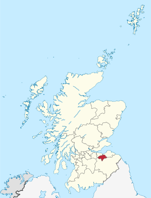
Midlothian (gälisch Meadhan Lodainn, seltener auch Edinburghshire) ist eine von 32 Council Areas in Schottland. Sie liegt südlich des Firth of Forth und grenzt an Edinburgh, East Lothian und Scottish Borders. Midlothian ist Partnerbezirk des ungarischen Komitats Komárom-Esztergom sowie des deutschen Kreises Heinsberg und außerdem eine der Lieutenancy Areas von Schottland.
Midlothian ist auch eine traditionelle Grafschaft. Als solche umfasst Midlothian auch Edinburgh und grenzt an West Lothian, East Lothian, Berwickshire, Selkirkshire sowie Peeblesshire.
Städte und Dörfer
- Bonnyrigg
- Crichton
- Dalkeith
- Danderhall
- Gorebridge
- Lasswade
- Loanhead
- Mayfield
- Newtongrange
- Penicuik
- Roslin
Sehenswürdigkeiten
- Rosslyn Chapel
- Scottish Mining Museum, ein Ankerpunkt der Europäischen Route der Industriekultur (ERIH)
- Butterfly and Insect World
- Vogrie Country Park
- Edinburgh Crystal
- Crichton Souterrain
- Crichton Castle
- Castlelaw Hillfort mit Souterrain
- Dalkeith Palace
- Pentland Hills
- Roslin Castle
- Water of Leith
- siehe auch Liste der Kategorie-A-Bauwerke in Midlothian
Politik
Der Council von Midlothian umfasst 18 Sitze, die sich wie folgt auf die Parteien verteilen:[2]
| Partei | Sitze |
|---|---|
| Scottish Labour | 9 |
| Scottish National Party | 6 |
| Liberal Democrats | 3 |
Einzelnachweise
- ↑ Mid-2012 Population (PDF; 1,2 MB)
- ↑ Midlothian Council: http://www.midlothian.gov.uk//topic.aspx?TopicID=14 Midlothian Councillors (Abgerufen am 13. April 2008)
Weblinks
Aberdeen | Aberdeenshire | Angus | Argyll and Bute | Clackmannanshire | Dumfries and Galloway | Dundee | East Ayrshire | East Dunbartonshire | East Lothian | East Renfrewshire | Edinburgh | Falkirk | Fife | Glasgow | Highland | Inverclyde | Midlothian | Moray | Äußere Hebriden | North Ayrshire | North Lanarkshire | Orkney | Perth and Kinross | Renfrewshire | Scottish Borders | Shetland | South Ayrshire | South Lanarkshire | Stirling | West Dunbartonshire | West Lothian
Aberdeenshire | Angus | Argyll | Ayrshire | Banffshire | Berwickshire | Bute | Caithness | Clackmannanshire | Cromartyshire | Dumfriesshire | Dunbartonshire | East Lothian | Fife | Inverness-shire | Lanarkshire | Kincardineshire | Kinross-shire | Kirkcudbrightshire | Midlothian | Morayshire | Nairnshire | Orkney | Peeblesshire | Perthshire | Renfrewshire | Ross-shire | Roxburghshire | Selkirkshire | Shetland | Stirlingshire | Sutherland | West Lothian | Wigtownshire