Northamptonshire
| Northamptonshire | |
|---|---|
 | |
| Geografie | |
| Status | Zeremonielle und Verwaltungsgrafschaft |
| Region | East Midlands |
| Fläche | 2.364 km² |
| Verwaltungssitz | Northampton |
| ISO 3166-2 | GB-NTH |
| Demografie | |
| Bevölkerung Dichte |
700.576 (2012)[1] 296 / km² |
| Distrikte | |
 | |
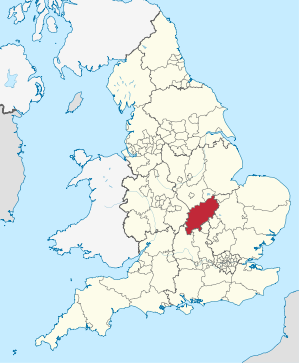
Northamptonshire [] (abgekürzt Northants) ist eine Grafschaft (County) in Zentralengland. Northamptonshire grenzt an Warwickshire, Leicestershire, Rutland, Cambridgeshire (mit Peterborough), Bedfordshire, Buckinghamshire (mit Milton Keynes), Oxfordshire und mit einer sehr kurzen Grenze (19 Meter) an Lincolnshire. Der Verwaltungssitz befindet sich in Northampton.
Der Soke of Peterborough gehörte früher zu Northamptonshire.
Städte und Ortschaften
- Brackley, Braunston, Burton Latimer
- Corby
- Daventry, Desborough
- Earls Barton
- Fotheringhay
- Kettering
- Lowick
- Marston St. Lawrence, Middleton, Moulton
- Naseby, Northampton
- Oundle
- Rothwell, Rushden
- Silverstone
- Thrapston, Towcester
- Wellingborough
Sehenswürdigkeiten
- Althorp House, Sitz des Earl Spencer
- Boughton House, Sitz der Herzöge von Buccleuch
- Canons Ashby House
- Schloss Ashby, Sitz des Marquess of Northampton
- Cottesbrooke Hall
- Deene Park
- Delapré Abbey
- Elton Hall
- Kirby Hall, Teil des English Heritage
- Schloss Rockingham
- Rockingham Motor Speedway
- Rushton Triangular Lodge, Teil des English Heritage
- Silverstone Circuit
- Stanford Hall
Weblinks
Einzelnachweise
Bedfordshire | Berkshire | Buckinghamshire | Cambridgeshire | Cheshire | Cornwall | Cumberland | Derbyshire | Devon | Dorset | Durham | Essex | Gloucestershire | Hampshire | Herefordshire | Hertfordshire | Huntingdonshire | Kent | Lancashire | Leicestershire | Lincolnshire | Middlesex | Norfolk | Northamptonshire | Northumberland | Nottinghamshire | Oxfordshire | Rutland | Shropshire | Somerset | Staffordshire | Suffolk | Surrey | Sussex | Warwickshire | Westmorland | Wiltshire | Worcestershire | Yorkshire
Grafschaften Englands mit zweistufiger Verwaltung (Non-Metropolitan Counties)
Cambridgeshire |
Derbyshire |
Devon |
East Sussex |
Essex |
Gloucestershire |
Hampshire |
Hertfordshire |
Kent |
Lancashire |
Leicestershire |
Lincolnshire |
Norfolk |
Nottinghamshire |
Oxfordshire |
Staffordshire |
Suffolk |
Surrey |
Warwickshire |
West Sussex |
Worcestershire
Unitary Authorities
mit County Status
Bath and North East Somerset |
Bedford |
Blackburn with Darwen |
Blackpool |
Bournemouth, Christchurch and Poole |
Brighton and Hove |
Bristol |
Buckinghamshire |
Central Bedfordshire |
Cheshire East |
Cheshire West and Chester |
Cornwall |
Cumberland |
County Durham |
Darlington |
Derby |
Dorset |
East Riding of Yorkshire |
Halton |
Hartlepool |
Herefordshire |
Isle of Wight |
Kingston upon Hull |
Leicester |
Luton |
Medway |
Middlesbrough |
Milton Keynes |
North East Lincolnshire |
North Lincolnshire |
North Northamptonshire |
North Somerset |
North Yorkshire |
Northumberland |
Nottingham |
Peterborough |
Plymouth |
Portsmouth |
Redcar and Cleveland |
Rutland |
Shropshire |
Somerset |
Southampton |
Southend-on-Sea |
South Gloucestershire |
Stockton-on-Tees |
Stoke-on-Trent |
Swindon |
Telford and Wrekin |
Thurrock |
Torbay |
Warrington |
West Northamptonshire |
Westmorland and Furness |
Wiltshire |
York
ohne County Status
Bracknell Forest |
Reading |
Slough |
West Berkshire |
Windsor and Maidenhead |
Wokingham
sui generis, ohne County Status
Isles of Scilly
Bedfordshire | Berkshire | Bristol | Buckinghamshire | Cambridgeshire | Cheshire | City of London | Cornwall | Cumbria | Derbyshire | Devon | Dorset | Durham | East Riding of Yorkshire | East Sussex | Essex | Gloucestershire | Greater London | Greater Manchester | Hampshire | Herefordshire | Hertfordshire | Isle of Wight | Kent | Lancashire | Leicestershire | Lincolnshire | Merseyside | Norfolk | North Yorkshire | Northamptonshire | Northumberland | Nottinghamshire | Oxfordshire | Rutland | Shropshire | Somerset | South Yorkshire | Staffordshire | Suffolk | Surrey | Tyne and Wear | Warwickshire | West Midlands | West Sussex | West Yorkshire | Wiltshire | Worcestershire
Koordinaten: 52° 18′ N, 0° 51′ W