Fontenay-sous-Fouronnes
| Fontenay-sous-Fouronnes | ||
|---|---|---|
| Staat | Frankreich | |
| Region | Bourgogne-Franche-Comté | |
| Département (Nr.) | Yonne (89) | |
| Arrondissement | Auxerre | |
| Kanton | Joux-la-Ville | |
| Gemeindeverband | Puisaye-Forterre | |
| Koordinaten | 47° 37′ N, 3° 36′ O | |
| Höhe | 149–273 m | |
| Fläche | 12,34 km² | |
| Einwohner | 73 (1. Januar 2021) | |
| Bevölkerungsdichte | 6 Einw./km² | |
| Postleitzahl | 89660 | |
| INSEE-Code | 89177 | |
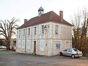
 Mairie in Fontenay-sous-Fouronnes | ||
Fontenay-sous-Fouronnes ist eine französische Gemeinde mit 73 Einwohnern (Stand: 1. Januar 2021) im Département Yonne in der Region Bourgogne-Franche-Comté (vor 2016 Bourgogne). Sie gehört zum Kanton Joux-la-Ville (bis 2015 Coulanges-sur-Yonne) im Arrondissement Auxerre.
Geographie
Fontenay-sous-Fouronnes liegt etwa 25 Kilometer südlich von Auxerre. Umgeben wird Fontenay-sous-Fouronnes von den Nachbargemeinden Val-de-Mercy im Norden, Bazarnes im Nordosten, Trucy-sur-Yonne im Osten, Mailly-le-Château im Süden und Südosten, Fouronnes im Westen sowie Charentenay im Nordwesten.
Bevölkerungsentwicklung
| Jahr | 1962 | 1968 | 1975 | 1982 | 1990 | 1999 | 2006 | 2013 |
| Einwohner | 105 | 101 | 85 | 76 | 74 | 73 | 75 | 73 |
| Quelle: Cassini und INSEE | ||||||||
Sehenswürdigkeiten
- Kirche Saint-Christophe

Weblinks
Commons: Fontenay-sous-Fouronnes – Sammlung von Bildern, Videos und Audiodateien
